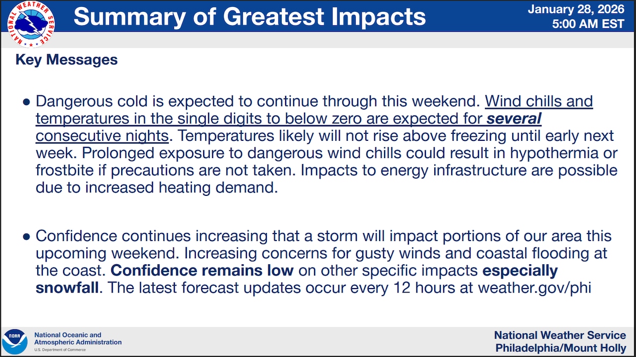
Dangerously cold temperatures with wind chills dropping below zero will persist through Thursday morning across the Lehigh Valley, Poconos and northwestern New Jersey, with the National Weather Service extending a Cold Weather Advisory through 10 a.m. Thursday.
A rapidly intensifying coastal storm developing this weekend could bring moderate to significant impacts from snow, strong winds and coastal flooding, though the exact track remains uncertain.
The Cold Weather Advisory remains in effect for an area including Bucks, Carbon, Lehigh, Monroe, Northampton, Warren and Hunterdon counties.
Wind chills will reach minus 15 to minus 18 degrees across the Pocono Plateau and minus 10 to minus 15 degrees in the Lehigh Valley. Daytime highs will remain well below freezing through the week, with overnight lows in the single digits to negative single digits.
 The National Weather Service warns of dangerously cold conditions with wind chills reaching minus 15 degrees and a major coastal storm possible this weekend.National Weather Service
Winds will be light Wednesday around 5 mph, but additional shots of arctic air will reinforce the cold through Friday night — potentially making each morning slightly colder than the previous one. Gusts up to 20 mph are forecast Thursday and Friday in the Lehigh Valley.
The National Weather Service notes this combination of prolonged arctic cold is “exceedingly rare” for the region and should be taken seriously for anyone venturing outside for extended periods.
Record-breaking low temperatures and record low high temperatures are possible Thursday through Saturday across multiple climate sites in the region.
At Lehigh Valley International Airport, the record low and record low maximum temperatures are as follows:
Jan. 29: minus 9 (1963) and 12 (1977)Jan. 30: minus 5 (1928) and 14 (1934)Jan. 31: minus 9 (1948) and 14 (2019)
A major coastal storm is expected to rapidly develop off the Southeast coast beginning Saturday and move northward Saturday night into Sunday.
While model guidance shows uncertainty regarding the exact track, the storm could bring the area significant impacts. If the storm tracks farther north along the coast before turning east, impacts would be greater; if it turns east more quickly, impacts would be more limited.
Potential impacts include heavy snow, strong winds and coastal flooding. Given the extremely cold air mass in place, all precipitation is expected to fall as snow.
The National Weather Service estimates a 40 percent probability of at least 2 inches of snow near the I-95 corridor. Probabilities are lower northwest toward the Lehigh Valley region.
Winds are forecast to increase Saturday night into Sunday morning, with northeast winds 15 to 25 mph gusting 25 to 35 mph and stronger toward the coast. These winds could cause damage, power outages and coastal water pileup.
The storm should pull away rapidly to the northeast by Sunday evening.
Generally tranquil but cold weather is expected for early next week as the system departs, with temperatures remaining well below average. Additional forecast details should become clearer as guidance is updated through the week.
Current weather radar