
TRACKING A WEEKEND NOR’EASTER | Latest models, tracks and timing
TOMORROW. THAT’S ALL THANKS TO HIGH PRESSURE THAT’S BUILDING IN AND IT WILL CONTINUE TO BUILD. NOW LET’S CHAT ABOUT THIS WEEKEND. I’M GOING TO SHOW YOU A COUPLE OF MODEL RUNS. SO THIS IS WHAT WE’RE THIS IS WHAT WE’RE LOOKING AT. THIS IS THE EUROPEAN MODEL. SO IT KEEPS THE SYSTEM DOWN TOWARDS THE COAST. BUT LOOK WHERE IT’S HEADED. OUT TO SEA. LOOK AT THIS. THE SNOW BANDS DON’T EVEN MAKE IT TOWARDS PENNSYLVANIA OR TOWARDS THE SUSQUEHANNA VALLEY CONTINUES TO GO OUT TO SEA. HERE’S THE AMERICAN MODEL THAT’S GOING TO CONTINUE TO GO OUT TO SEA. YOU CAN SEE SOME BANDS MAKE IT INTO NEW JERSEY. BUT LOOK AT THIS. THE CENTER OF THAT LOW PRESSURE IS GOING OUT TO SEA. THIS IS WHAT WE’RE WATCHING AS WE GO THROUGH THE NEXT SEVERAL DAYS, AND WE’RE GOING TO CONTINUE TO, TO TO PINPOINT THE EXACT TRACK AND THE TOTALS. IF IT EVEN GETS CLOSE ENOUGH FOR IMPACTS RIGHT NOW, IT IS A LOW CHANCE OF PRECIPITATION ONCE WE GET INTO THE WEEKEND. SO IMPACT PERIOD FROM WEDNESDAY THROUGH SATURDAY. THAT’S FOR THE BRISK AND FRIGID CHILLS, BY THE WAY, UP UNTIL SATURDAY. STILL GOING TO BE WATCHING THE COAST THOUGH. LOOKING AHEAD INTO NEXT WEEK.
TRACKING A WEEKEND NOR’EASTER | Latest models, tracks and timing

Updated: 1:30 PM EST Jan 28, 2026
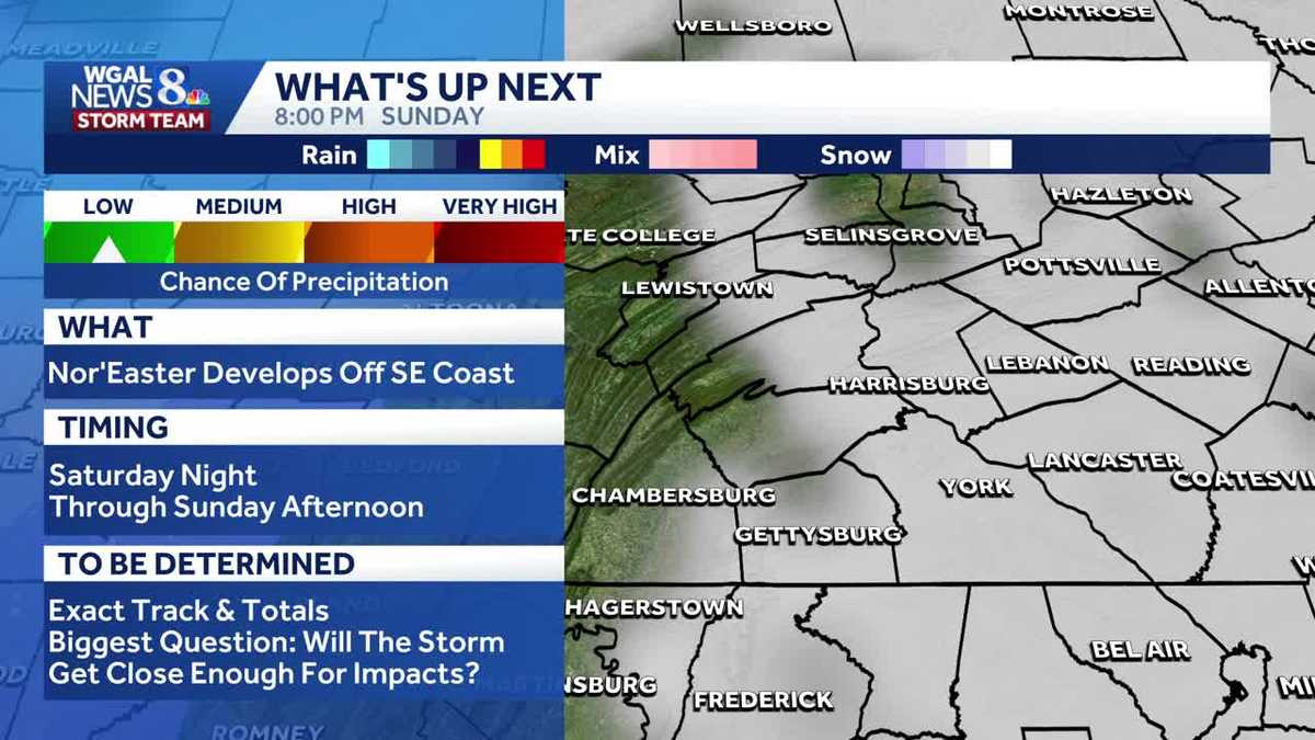
A nor’easter is expected to bring snow this weekend to parts of the U.S., but it’s still too early to tell whether it will impact Pennsylvania. What does the American model show?The latest on the American model keeps the snow and the track away from South-Central Pennsylvania.This track (from Wednesday morning) is closer to what the European and the Canadian models had been showing. The big question and yet to be determined – the exact track and how close the storm gets to Pennsylvania.Canadian, European modelThe Canadian and the European keep the nor’easter well off the coast, but there are still some questions there to be answered. The models have been shifting back and forth a bit.The next model runs could shift west, but we’ll keep you posted.Storm timing and track overallSaturday night through Sunday afternoon.Key uncertainty: how far west the storm tracks — a westward shift would increase impacts and totals.Expected impactsChance of precipitation: low.Snow totals: still TBD — watch model trends for adjustments.What to watch nextMonitor model updates Saturday evening for the storm’s west/east shift.Check local forecasts before Sunday morning commute.SOUTH-CENTRAL PA WEATHER RESOURCES: INTERACTIVE RADAR | ACTIVE WEATHER ALERTS | CURRENT CONDITIONS | HOURLY FORECAST | 10-DAY FORECAST | WEEKEND FORECAST | MAP ROOM | DOWNLOAD THE APP | WEATHER EMAILS
A nor’easter is expected to bring snow this weekend to parts of the U.S., but it’s still too early to tell whether it will impact Pennsylvania.
What does the American model show?


The latest on the American model keeps the snow and the track away from South-Central Pennsylvania.This track (from Wednesday morning) is closer to what the European and the Canadian models had been showing. The big question and yet to be determined – the exact track and how close the storm gets to Pennsylvania.Canadian, European model


The Canadian and the European keep the nor’easter well off the coast, but there are still some questions there to be answered. The models have been shifting back and forth a bit.The next model runs could shift west, but we’ll keep you posted.Storm timing and track overall

Saturday night through Sunday afternoon.Key uncertainty: how far west the storm tracks — a westward shift would increase impacts and totals.Expected impactsChance of precipitation: low.Snow totals: still TBD — watch model trends for adjustments.What to watch next

Monitor model updates Saturday evening for the storm’s west/east shift.Check local forecasts before Sunday morning commute.

SOUTH-CENTRAL PA WEATHER RESOURCES: INTERACTIVE RADAR | ACTIVE WEATHER ALERTS | CURRENT CONDITIONS | HOURLY FORECAST | 10-DAY FORECAST | WEEKEND FORECAST | MAP ROOM | DOWNLOAD THE APP | WEATHER EMAILS