
Western PA: Record cold this weekend, then moderating temperatures
Record low temperatures are possible for Pittsburgh on Friday and Saturday.
OF OUR RIVERS, IT IS SO ICY OUT THERE. YEAH. AND OUR ICE WILL KEEP THICKENING UP AS WE CONTINUE THROUGH THE REST OF THE WEEK AS OUR TEMPERATURES STAY ON THE COLD SIDE. THERE’S NO BIG WARMING TREND ANYTIME SOON. WE WILL TRY TO GET CLOSER TO NORMAL AS WE START FEBRUARY. TOMORROW WE’LL GO BACK ON IMPACT DAY AS WELL AS WE’LL BE WATCHING FOR SINGLE DIGIT WIND CHILLS ON BOTH SIDES OF ZERO, STARTING IN THE MORNING AND CONTINUING INTO THE DAY. THEN SEVERE WEATHER ALERT DAY FOR FRIDAY AND SATURDAY. WE COULD SET RECORD LOWS BOTH MORNINGS. SATURDAY MORNING COULD BE THE COLDEST WE’VE BEEN IN JUST OVER A YEAR, AND THE COLDEST OF THIS STRETCH. BEFORE WE START HEADING IN THE RIGHT DIRECTION AGAIN TONIGHT, A COLD WEATHER ADVISORY IS IN EFFECT FOR ALL OF WESTERN PENNSYLVANIA. THIS WILL LAST UNTIL 10:00 TOMORROW MORNING. AGAIN, IF YOU DON’T HAVE TO GO OUTSIDE EARLY, WIND CHILLS WILL BE SITTING GENERALLY BETWEEN ABOUT TEN AND 15 DEGREES BELOW ZERO. STARTING THE DAY, AIR TEMPERATURES HAVE REALLY STRUGGLED TO WARM TODAY, EVEN THOUGH WE’VE GOTTEN SOME SUNSHINE WITH THE COLD AIR IN PLACE AND FRESH SNOWPACK STILL, THAT REALLY MAKES IT STRUGGLE FOR TEMPERATURES TO TRY AND WARM. WE’RE SITTING IN THE TEENS PRETTY MUCH ACROSS THE BOARD. FRANKLIN’S AT NINE, DUBOIS IS AT EIGHT, SOMERSET ALSO AT NINE. WE FACTOR THE WIND AND IT FEELS LIKE IT’S ZERO AT THE AIRPORT. THREE BELOW IN GREENSBURG, FIVE BELOW IN FRANKLIN, ONE BELOW IN KITTANNING. FEELS LIKE IT’S ALSO ONE BELOW IN WASHINGTON. AND AGAIN, THESE WIND CHILLS AGAIN WILL GET WORSE AS WE HEAD THROUGH THE NIGHT TONIGHT. BY THE TIME WE GET TO TOMORROW MORNING, EXPECT WIND CHILLS GENERALLY BETWEEN ABOUT EIGHT AND 15 DEGREES BELOW ZERO. SO ANOTHER COLD START TO THE DAY. IF KIDS ARE HEADING BACK TOMORROW, MAKE SURE THEY ARE BUNDLED UP AND WIND CHILLS SLOWLY IMPROVE. JUST LIKE TODAY. BACK TOWARDS ZERO. BY THIS TIME TOMORROW. AND THEN WE GET EVEN COLDER AS WE HEAD INTO FRIDAY. WILL GO ON SEVERE WEATHER ALERT DAY AS WIND CHILLS WILL AGAIN SIT BETWEEN ABOUT TEN AND 20 DEGREES BELOW ZERO. AIR TEMPERATURES WILL ALSO BE VERY COLD ON FRIDAY MORNING, SO WE’LL START AT TWO TOMORROW. WE’LL FINISH AT 15, THEN FRIDAY AND SATURDAY MORNINGS AGAIN. RECORD LOWS AT SEVEN BELOW AND EIGHT BELOW. THE RECORDS. BOTH MORNINGS ARE FIVE BELOW. WE SHOULD BREAK THOSE. WE’LL STRUGGLE BACK TO 12. WIND CHILLS SATURDAY MORNING COULD GET TO 20 TO 25 BELOW ZERO WITH HOW COLD IT’S GOING TO BE. WE’LL START AT ZERO ON SUNDAY. WE’LL GO AN IMPACT DAY ONE MORE TIME BACK TO 17, AND THEN FINALLY A MORE SEASONABLY COLD STRETCH. STILL COLD, BUT CLOSER TO WHERE WE SHOULD BE. 24 MONDAY 28 TUESDAY. TEMPERATURES NEAR 30 WEDNESDAY AND THURSDAY. RIGHT NOW IT DOES NOT LOOK LIKE WE BREAK FREEZING, BUT 29 IS GOING TO FEEL LIKE A HEAT WAVE COMPARED TO WHERE WE HAVE BEEN. SO IT IS STILL COLD AND IT IS ICY OUT THERE ON ACTION. CAM 12 IS THE CURRENT TEMPERATURE. WINDS ARE SOUTHWEST AT NINE. IF YOU ARE HEADING OUT AGAIN, WIND CHILLS WILL DROP THROUGH THE NIGHT. MAKE SURE YOU’RE BUNDLED UP.
Western PA: Record cold this weekend, then moderating temperatures
Record low temperatures are possible for Pittsburgh on Friday and Saturday.

Updated: 4:35 PM EST Jan 28, 2026
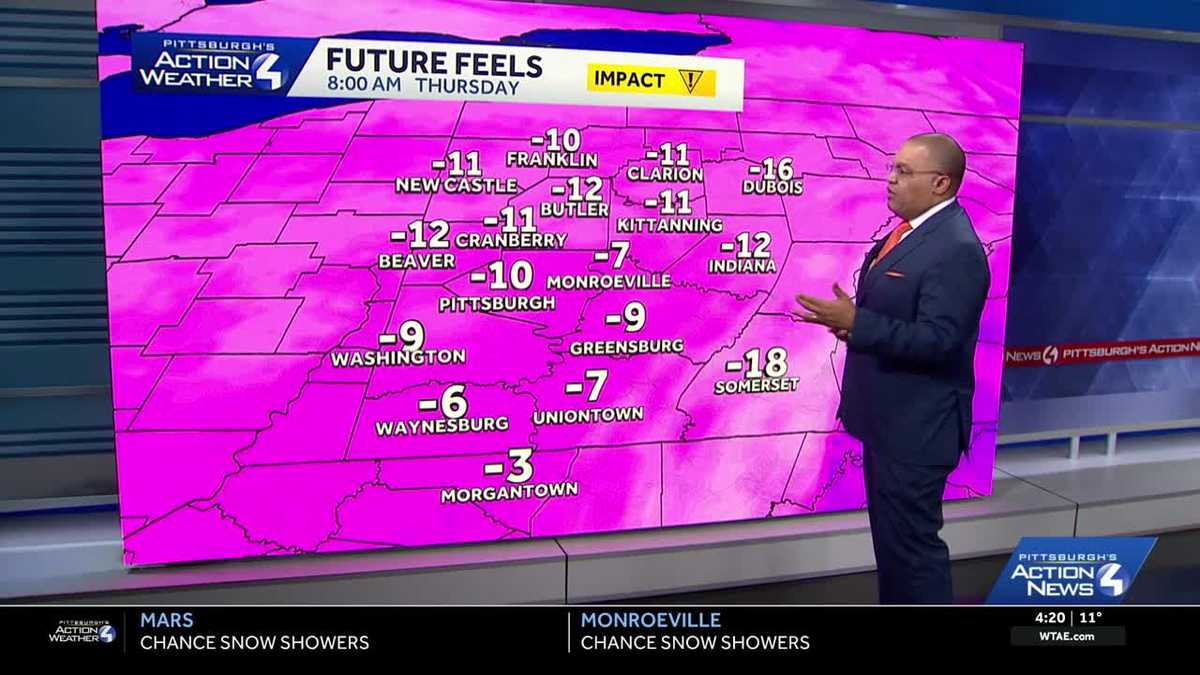
Thursday is an Impact Day. Daytime highs will only reach the low-to-mid teens. Record low temperatures are likely Friday and Saturday morning before we finally break the bitter cold.Impact Day and Cold Weather AdvisoriesAnother Cold Weather Advisory goes into effect for the entire area starting at 7 p.m. Wednesday and lasts until 11 a.m. Thursday. Wind chills will again be up to -15° in the morning and rebound close to 0° in the afternoon.Alert Days: Record lows possible for PittsburghWe will go back to Severe Weather Alert Days for Friday and Saturday. Pittsburgh could break record low temperatures both days – both records are -5° set in 2019. Afternoon highs will only manage the lower teens. Saturday morning will likely be the coldest morning as some places could wake up in the negative teens. Fortunately, the wind will be light, so wind chills won’t be much worse than the air temperature.The cold eases slightly in early FebruaryAt this time, a weekend coastal storm looks to stay far enough east that the Pittsburgh area won’t see any impacts. We will continue to monitor the track for any dramatic changes. Temperatures will remain below freezing for early February. But instead of the teens, highs will be in the 20s.TONIGHT: Partly to mostly cloudy. Low: 2°.THURSDAY – Impact Day: Bitterly cold with limited sunshine. High: 15°, low: -7°.FRIDAY – Severe Weather Alert Day: Record low possible. Mostly cloudy and bitterly cold. High: 12°, low: -8°.SATURDAY – Severe Weather Alert Day: Record low possible. Mostly cloudy and frigid. High: 12°, low: 0°.
PITTSBURGH —
Thursday is an Impact Day. Daytime highs will only reach the low-to-mid teens. Record low temperatures are likely Friday and Saturday morning before we finally break the bitter cold.
Impact Day and Cold Weather Advisories
Another Cold Weather Advisory goes into effect for the entire area starting at 7 p.m. Wednesday and lasts until 11 a.m. Thursday. Wind chills will again be up to -15° in the morning and rebound close to 0° in the afternoon.

Hearst Owned
Another Cold Weather Advisory for the entire area between 7 p.m. this evening and 11 a.m. Thursday.
Alert Days: Record lows possible for Pittsburgh
We will go back to Severe Weather Alert Days for Friday and Saturday. Pittsburgh could break record low temperatures both days – both records are -5° set in 2019. Afternoon highs will only manage the lower teens. Saturday morning will likely be the coldest morning as some places could wake up in the negative teens. Fortunately, the wind will be light, so wind chills won’t be much worse than the air temperature.

Hearst Owned
Friday and Saturday are Alert Days for the potential of record low temperatures.
The cold eases slightly in early February
At this time, a weekend coastal storm looks to stay far enough east that the Pittsburgh area won’t see any impacts. We will continue to monitor the track for any dramatic changes. Temperatures will remain below freezing for early February. But instead of the teens, highs will be in the 20s.

Hearst Owned
We still have the worst of the cold to go, then finally seasonably cool readings to start February.
TONIGHT: Partly to mostly cloudy. Low: 2°.
THURSDAY – Impact Day: Bitterly cold with limited sunshine. High: 15°, low: -7°.
FRIDAY – Severe Weather Alert Day: Record low possible. Mostly cloudy and bitterly cold. High: 12°, low: -8°.
SATURDAY – Severe Weather Alert Day: Record low possible. Mostly cloudy and frigid. High: 12°, low: 0°.