
Western PA: Two more Impact Days for the bitter cold
No real change with temperatures remaining below freezing for the week ahead.
HAVE A GREAT SUNDAY, EVERYONE. I’M ASHLEY AND THAT’S PITTSBURGH’S ACTION SPORTS. PITTSBURGH’S ACTION SPORTS 4 PITTSBURGH’S ACTION WEATHER 4 BACK WITH ANOTHER CHECK OF OUR CERTIFIED MOST ACCURATE FORECAST ON THIS IMPACT. IT’S ALL A MATTER OF PERSPECTIVE RIGHT? IT’S BEEN VERY COLD. REALLY. EVERY DAY. BRAND NEW ADJECTIVES TO DESCRIBE IT. SO TODAY MAYBE A LITTLE BIT ONE OF THOSE EASIER MORNINGS TO HANDLE. AS MANY OF US ARE SEEING WIND CHILLS RIGHT NOW. CLOSE TO ZERO. THAT’S THE CASE OUT OF PITTSBURGH INTERNATIONAL. OBVIOUSLY A LITTLE BIT HARSHER FOR THOSE OF YOU IN INDIANA, TALK ABOUT GREENSBURG, UNIONTOWN ALL FEELING LIKE ABOUT 6 TO 7 DEGREES BELOW ZERO. AND WE WILL SLOWLY SEE THOSE NUMBERS IMPROVE BUT STILL FRIGID THIS MORNING. SAME STORY TOMORROW MORNING. SO THAT WOULD EXTEND OUR SLEW OF IMPACT AND ALERT DAYS, NOT QUITE AS COLD INTO THE UPCOMING WEEK. WE’RE NOT GOING TO SEE AS MANY DAYS IN THE TEENS HIGHS, INSTEAD PUSHING INTO THE 20S. BUT ALONG THE WAY, WE ALSO COULD INTRODUCE A FEW PASSING SNOW CHANCES. NOT EXPECTING A WHOLE LOT, BUT MAYBE A LITTLE BIT TO FRESHEN UP SOME OF THE SNOW THAT IS STARTING TO DEVELOP ALONG THE SIDES OF THE ROADS AT THIS POINT. COMING OFF OF A COURSE LAST SUNDAY, BIG WINTER STORM AS YOU WORK OVER THE NEXT COUPLE OF HOURS, SOME TEMPERATURES GETTING CLOSER TO ZERO, AT LEAST WHEN YOU FACTOR IN THE WIND AS WE GO THROUGH THE AFTERNOON. SIMILAR STORY FEELING LIKE THE SINGLE DIGITS TO AROUND ZERO ON THIS IMPACT DAY. WINDS GOING TO STAY ELEVATED TONIGHT. TEMPERATURES WILL EASE BACK INTO THE SINGLE DIGITS. SO STILL TALKING ABOUT WIND CHILLS AS YOU’RE STEPPING OUT THE DOOR MONDAY MORNING. THERE COULD BE ANYWHERE FROM FIVE TO EVEN 15 DEGREES BELOW ZERO, SO WE WILL KEEP THAT IMPACT DAY GOING, ESPECIALLY AS THE KIDS ARE HEADING BACK INTO THE CLASSROOM FOR THE FIRST TIME IN OVER A WEEK. BY THE AFTERNOON TOMORROW, AROUND 25, WE’LL SEE A GRADUAL UPTICK IN CLOUD COVER THAT COULD EVEN PRODUCE A FEW STRAY FLURRIES LATE IN THE DAY MONDAY. BETTER OPPORTUNITY TO SEE SOME FLAKES FLYING LATE TUESDAY, ESPECIALLY SOUTH OF THE CITY. THAT REINFORCES THEN THE ARCTIC FEEL. MIDDLE OF THE WEEK, BUT WE’LL KEEP AN EYE ON FRIDAY, WHICH MAY BECOME OUR NEXT IMPACT DAY FOR SOME IMPACTS FROM SNOW ACCUMULATION SHOULD BE REALLY LIGHT. MEANWHILE, AS WE LOOK AROUND ALLEGHENY COUNTY RIGHT NOW, WE ARE PICKING UP ON A FEW BURST OF SNOW. FEW FLURRIES AROUND WILKINSBURG, THE FOREST HILLS AREA, EVEN JUST OUTSIDE OF MCKEESPORT. MEANWHILE, TRYING TO COME INTO THE CITY, WORKING RIGHT ALONG ROUTE 65 AND THE OHIO RIVER. ANOTHER BAND OF SOME LIGHT SNOW THAT HAS BEEN STREAMING IN FOR THE PAST SEVERAL HOURS, AS MORE THAN LIKELY, SOME OF THE INDUSTRY IN BEAVER COUNTY, SOME OF THE STEAM THAT’S BEEN LET OFF ACTUALLY INTERACTING WITH THESE VERY FRIGID TEMPERATURES, PRODUCING SOME OF THOSE BANDS, A VERY LIGHT SNOW. SO THE FUTURECAST NOT PICKING UP ON THAT ACTIVITY, BUT WHAT IT DOES SHOW IS AS WE GO THROUGHOUT THE DAY, WE’LL INTRODUCE MORE SUNSHINE HERE ON YOUR SUNDAY. CLOUDS WILL FILTER BACK IN AGAIN. THAT HELPS US OUT. KEEPS US FROM DROPPING BELOW ZERO FOR AIR TEMPERATURE TONIGHT, AND WILL INTRODUCE SOME RAYS OF SUNSHINE AS WE WORK THROUGH MIDDAY. MONDAY MAY CATCH A FEW FLURRIES AS CLOUDS RETURN INTO THE EVENING AND OVERNIGHT HOURS. THAT COULD CREATE A FEW DUSTY SPOTS AS YOU’RE HEADING OUT THE DOOR TUESDAY MORNING. BUT THE MAIN SYSTEM ARRIVES INTO THE AFTERNOON AND EVENING HOURS. FUTURECAST NOW TRYING TO BRING SOME OF THAT SNOW FARTHER NORTH, BUT I THINK THE ACCUMULATION MORE THAN LIKELY IS GOING TO STAY WELL TO OUR SOUTH, ESPECIALLY SOUTH OF I-70. SO TAKING A LOOK AT ACCUMULATIONS ON TUESDAY FOR MOST OF US, AMOUNTS WILL BE UNDER AN INCH, MAYBE AN INCH AND A HALF SOUTH OF I-70. BUT ONCE THAT SYSTEM CLEARS US, WE REINFORCE THAT FRIGID FEELING. WE START IN THE SINGLE DIGITS, NOT JUST WEDNESDAY THURSDAY AS WELL, WITH HIGH TEMPERATURES IN THE LOW TO MID 20S. FRIDAY, A DAY THAT WILL WATCH THIS IS A CLIPPER DOESN’T TYPICALLY CARRY A WHOLE LOT OF MOISTURE, SO ACCUMULATIONS WOULD BE A FEW INCHES AT BEST. BUT WE COULD SEE SOME OF THAT SNOW HITTING IN TIME FOR THE FRIDAY EVENING COMMUTE. SO WE’LL CONTINUE TO MONITOR THOSE TRENDS IN TERMS OF TIMING AND ACCUMULATIONS THROUGH THE WEEK. YOU PROBABLY DON’T WANT TO SEE THIS IN YOUR 4-DAY PLUS 4 MORE FORECAST IT GETS COLDER AGAIN BEHIND THE SNOW. YOU’RE NOT RID OF TEMPERATURES AROUND ZERO FOR LOWS. HIGHS IN THE TEENS. THAT LOOKS TO BE COMING OUR WAY NEXT WEEK AS THE SECOND WEEK OF FEBRUARY LOOKS TO BE COLDER. SO WE GET THE RELIEF THIS WEEK. BUT THEN IT’S ALMOST LIKE WE’RE REDOING WHAT WE JUST DID THIS PAST WEEK. THE SECOND WEEK OF FEBRUARY, OR LIKE THE 37TH WEEK OF JANUARY. NO, IT DOESN’T MATTER WHAT DAY IT IS, RIGHT? IT’S STILL WINTER, IT’S STILL GRAY. IT’S STILL COLD. WE APPRECIATE YOUR UPDATES. ALL THE ONES YOU HAVE DONE AND ALL
Western PA: Two more Impact Days for the bitter cold
No real change with temperatures remaining below freezing for the week ahead.

Updated: 5:28 PM EST Feb 1, 2026
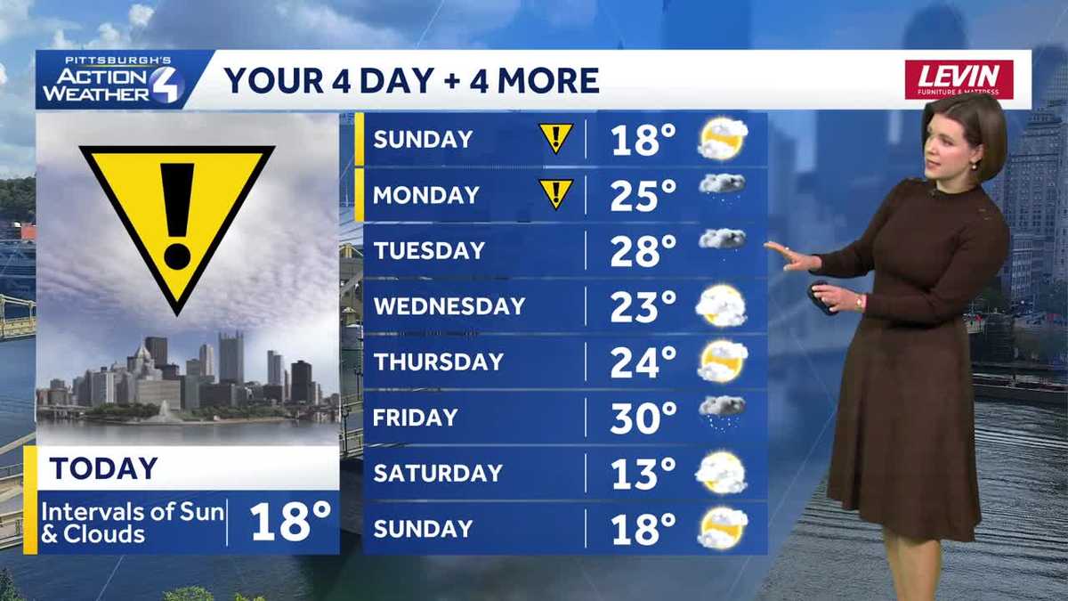
The impacts from the Arctic blast will ease slightly over the coming days. However, Monday is an Impact Day for hours of sub-zero wind chills. Along with more cold blasts, we are tracking a couple snow chances this week.Impact Day for the last of brutal cold Monday/Groundhog Day will begin with another round of frigid wind chills. We will lift the Impact Day by late morning. Air temperatures will return to the 20s for the first time since last Sunday. A few flurries are possible, especially late in the day.Snow showers, temps below freezing this weekTuesday will be slightly warmer with morning temperatures in the teens and highs pushing into the upper 20s. A few light snow showers will pass through western Pennsylvania. Any accumulations will be less than an inch. A fresh batch of Arctic air arrives as this system departs. Lows will return to the single digits with highs in the teens for Wednesday and Thursday. Fortunately, the wind will remain light so the wind chill shouldn’t be much of a factor over these frigid starts.Watching for more snowThe next system to watch could bring more snow to western Pennsylvania on Friday. At this point, the long range forecast suggests 1-3″ of snow is possible. We will keep you updated on the trends. While Friday will be the “snowiest” day of the week, it will also be the “warmest” with a high near 30 degrees.This storm will unlock another bitter blast with temperatures returning to the teens next weekend. The prolonged cold will extend into the second week of February. OVERNIGHT – Impact Day: Wind chills up to -10°. Partly to mostly cloudy. Low: 2°.MONDAY – Impact Day: Frigid start. Mostly cloudy with flurries. High: 25°, low: 20°.TUESDAY: Isolated snow showers. Cloudy and not as cold. High: 30°, low: 9°.WEDNESDAY: Colder with gray skies. High: 23°, low: 7°.
PITTSBURGH —
The impacts from the Arctic blast will ease slightly over the coming days. However, Monday is an Impact Day for hours of sub-zero wind chills. Along with more cold blasts, we are tracking a couple snow chances this week.
Impact Day for the last of brutal cold

Hearst OwnedHearst
An Impact Day for sub-zero and single digit wind chills today for western PA.
Monday/Groundhog Day will begin with another round of frigid wind chills. We will lift the Impact Day by late morning. Air temperatures will return to the 20s for the first time since last Sunday. A few flurries are possible, especially late in the day.

Hearst OwnedHearst
A frigid start to Groundhog Day with sub-zero wind chills.
Snow showers, temps below freezing this week
Tuesday will be slightly warmer with morning temperatures in the teens and highs pushing into the upper 20s. A few light snow showers will pass through western Pennsylvania. Any accumulations will be less than an inch. A fresh batch of Arctic air arrives as this system departs. Lows will return to the single digits with highs in the teens for Wednesday and Thursday. Fortunately, the wind will remain light so the wind chill shouldn’t be much of a factor over these frigid starts.

Hearst OwnedHearst
A system passing to our south will toss isolated snow showers our way. Locally higher accumulations are expected south of I-70.
Watching for more snow
The next system to watch could bring more snow to western Pennsylvania on Friday. At this point, the long range forecast suggests 1-3″ of snow is possible. We will keep you updated on the trends. While Friday will be the “snowiest” day of the week, it will also be the “warmest” with a high near 30 degrees.
This storm will unlock another bitter blast with temperatures returning to the teens next weekend. The prolonged cold will extend into the second week of February.

Hearst OwnedHearst
The Arctic impacts continue with more bitter cold and snow chances, especially on Friday.
OVERNIGHT – Impact Day: Wind chills up to -10°. Partly to mostly cloudy. Low: 2°.
MONDAY – Impact Day: Frigid start. Mostly cloudy with flurries. High: 25°, low: 20°.
TUESDAY: Isolated snow showers. Cloudy and not as cold. High: 30°, low: 9°.
WEDNESDAY: Colder with gray skies. High: 23°, low: 7°.