
Sunshine with brisk & frigid conditions persisting; snow chances this week in south-central Pennsylvania
Temperatures remain below average for the next several days. Snow chances return for the upcoming week.
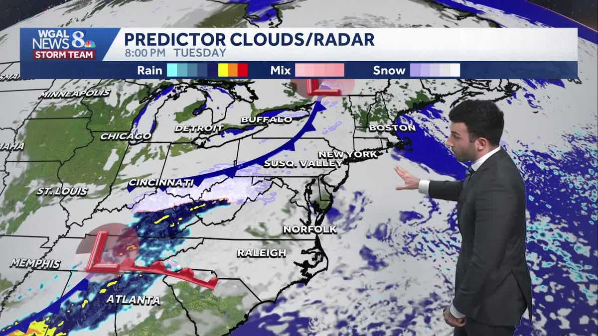
TO GOBBLER’S KNOB AND RYAN, I KNOW THAT A LOT OF PEOPLE ARE GOING TO BE OUT TOMORROW AND HOPING THAT PHIL PREDICTS SOME AN EARLY SPRING, NOT SIX MORE WEEKS OF WINTER. YEAH, SURE. CAN WE EXPECT THAT? SO IT’S LOOKING SHADOW FRIENDLY IS WHAT I’LL SAY FOR OUR FORECAST FOR MONDAY. WE’RE GOING TO BE SEEING SOME MOSTLY SUNNY CONDITIONS AS WE GET INTO OUR MONDAY. BUT BEFORE WE GET INTO OUR MONDAY, STILL GOING TO BE DEALING WITH THESE WIND CHILLS INTO THE SINGLE DIGITS AND POSSIBLY NEAR ZERO DEGREES FOR TONIGHT. WITH THOSE WIND GUSTS, THOUGH, THEY WILL BE IN THE SLIGHTLY DIMINISHED. WE’LL STILL SEE A BIT OF A BREEZE FOR OUR MONDAY, BUT THEN AS WE GET INTO AS WE GET INTO THE REST OF THIS WEEK, WE’RE SLIGHTLY WARMER. I DON’T EVEN WANT TO CALL IT WARMER. IT’S STILL COLD. IT’S GOING TO BE NEAR 32 DEGREES FOR TUESDAY, BUT WE ARE TRACKING A FEW MORE CHANCES FOR SOME SNOW, SPECIFICALLY LATE TUESDAY INTO WEDNESDAY MORNING AND FRIDAY AFTERNOON INTO FRIDAY EVENING. BUT LET’S CHAT ABOUT THAT HERE IN THE FULL FORECAST. SO CLEAR SKIES. WE HAVE CHILLS NEAR ZERO DEGREES FOR TONIGHT. 12 DEGREES WILL BOTTOM OUT AT THEN 18 DEGREES WILL BE MOSTLY SUNNY. A LITTLE WINDY FOR TOMORROW MORNING. SO DEFINITELY GOING TO BE FEELING A LOT CHILLIER. BUT WITH THE WIND DYING DOWN FOR TOMORROW AFTERNOON, WE’LL HAVE MOSTLY SUNNY CONDITIONS. TEMPERATURES RIGHT AROUND 28 DEGREES WON’T BE FEELING AS COLD AS WE GET INTO THE AFTERNOON. SUNDAY 26 DEGREES WAS OUR HIGH FOR TODAY. EARLIER THIS MORNING HIT RIGHT AROUND 11 DEGREES. NO SNOWFALL RECORDED AT HARRISBURG INTERNATIONAL AIRPORT, BUT WE’RE TALKING ABOUT GROUNDHOG DAY. SO HERE’S THE DETAILS THOUGH. IF IF PHIL OR THE ANY LOCAL ANY LOCAL GROUNDHOG SEE THEIR SHADOW, THAT MEANS SIX MORE WEEKS OF WINTER FOLKS. SO WE WILL BE SEEING MOSTLY SUNNY CONDITIONS. SO SHADOWS ARE POSSIBLE FOR 8:00 IN THE MORNING. SINGLE DIGIT CHILLS WILL BE ON TAP FOR 9:00 AS WE HAVE THOSE WINDS STILL PERSISTENT OUT OF THE NORTHWEST. I’D SAY BETWEEN 10 AND 15MPH. BUT IN TERMS OF CONSECUTIVE DAYS BELOW 32 DEGREES, COUNTING TODAY. SO FAR, NINE DAYS OF CONSECUTIVE DAYS BELOW 32. THAT’S BEEN SINCE JANUARY 24TH, BY THE WAY. SO LET’S RECAP JANUARY 20TH 2620 6.6 DEGREES WAS THE AVERAGE TEMPERATURE. HIGHEST TEMPERATURE WAS 57. LOWEST LOW WAS 02.2 TWO INCHES OF RAINFALL AND 15.2IN OF SNOWFALL, WHICH IS A LITTLE BIT ABOVE AVERAGE FOR JANUARY STANDARDS NOW. FEBRUARY PREVIEW 39 IS WHAT WE EXPECT FOR THIS TIME OF YEAR. ONCE WE GET TO THE END OF FEBRUARY, IT’S GOING TO BE 46 DEGREES, SO WE CAN’T WAIT FOR THAT. CAN YOU EXPECT? WE’VE HAD A LOT OF PEOPLE REACH OUT LIKE, HEY, BRING BRING THE WARMTH BACK, RYAN, GIVE US SOME BETTER NEWS. DON’T BE KEEPING US BELOW FREEZING. BUT TEMPERATURES INTO THE 20S RIGHT NOW. 23 IN LANCASTER, 24 IN LEBANON, 19 IN LEWISTOWN. STILL GOT THAT NORTHWESTERLY BREEZE GENERALLY BETWEEN 15 C 16MPH IN HARRISBURG AND LEBANON, 14MPH IN LANCASTER. BUT IT’S MAKING IT FEEL A LOT COLDER OUT THERE, FEELING LIKE THE SINGLE DIGITS. SO STORM TEAM, LIVE RADAR NETWORK, ALL IS QUIET. YOU SEE SOME OF THESE HIGH LEVEL CLOUDS STILL OVER FAR EASTERN PORTIONS OF THE COMMONWEALTH. THAT’S ALL THANKS TO THE LOW PRESSURE SYSTEM, BY THE WAY, THAT IMPACTED THE CAROLINA COASTLINE THAT’S MOVING OUT TO SEA. NOW WE HAVE SOME HIGH PRESSURE THAT’S GOING TO DEVELOP AND HELP TO NOT ONLY RELAX THE WINDS, BUT KEEP OUR SKIES CLEAR. ONCE WE GET INTO OUR MONDAY, AND ALSO GETTING INTO OUR MONDAY EVENING. NOW, JUMPING AHEAD INTO OUR TUESDAY CLOUDS DO START TO BUILD UP A LITTLE BIT. THERE’S A DISTURBANCE TOWARDS OUR NORTH AND THIS AND A DISTURBANCE TOWARDS OUR SOUTH THAT’S GOING TO MOVE THROUGH THE TENNESSEE RIVER VALLEY, AND THAT’S GOING TO MOVE ITS WAY TOWARDS THE SUSQUEHANNA VALLEY AND ALLOW SLIGHT CHANCE FOR SOME SNOW SHOWERS FOR LATE TUESDAY NIGHT GETTING INTO OUR WEDNESDAY. SO WE HAVE THAT EARLY MORNING SNOW SHOWER CHANCE HIGHLIGHTED FOR OUR WEDNESDAY. HERE WE GO FOR THE REST OF THE WORKWEEK. NOT REALLY GETTING MUCH ABOVE 32 DEGREES. GETTING BACK DOWN TO THE 2
Sunshine with brisk & frigid conditions persisting; snow chances this week in south-central Pennsylvania
Temperatures remain below average for the next several days. Snow chances return for the upcoming week.

Updated: 11:19 PM EST Feb 1, 2026
Skies will remain mainly clear this evening with temperatures lowering through the lower 20s. As a large coastal low moves out to sea, northwesterly winds will continue at about 15-25 mph. Some areas may experience gusts to 35 mph. The wind will make it feel like the single digits all evening.Tonight, strong gusts diminish, but 10-20 mph winds will linger. Lows will fall to the teens, and wind chills will be around 0, if not a few degrees below. The National Weather Service is considering another Cold Weather Advisory early Monday.Mostly sunny skies are in store Monday, as high pressure moves into the Mid-Atlantic states. Highs will be slightly warmer, in the upper 20s. It won’t be as windy as Sunday, but a 10-15 mph breeze will keep wind chills in the teens.Calmer and cloudier conditions are in store Tuesday. Highs will finally warm to 32 degrees, after a 10-day stretch below freezing.A quick-moving system will pass to our south Tuesday night, leading to a chance of light snow showers. Snow should be gone around or shortly after sunrise Wednesday. Partly sunny skies are in store Wednesday afternoon, with highs near 30 degrees.Thursday will be blustery and cold. Highs will reach the upper 20s, but it will feel like the teens.We’re watching a clipper, which could bring light snow across the area Friday afternoon and evening. It will turn windy and colder behind that system, leading to highs in the low 20s and lows in the single digits over the weekend, along with blustery winds. The cold isn’t done with us yet!Stay warm, and have a good rest of your night!~ Ryan
Skies will remain mainly clear this evening with temperatures lowering through the lower 20s. As a large coastal low moves out to sea, northwesterly winds will continue at about 15-25 mph. Some areas may experience gusts to 35 mph. The wind will make it feel like the single digits all evening.
Tonight, strong gusts diminish, but 10-20 mph winds will linger. Lows will fall to the teens, and wind chills will be around 0, if not a few degrees below. The National Weather Service is considering another Cold Weather Advisory early Monday.
Mostly sunny skies are in store Monday, as high pressure moves into the Mid-Atlantic states. Highs will be slightly warmer, in the upper 20s. It won’t be as windy as Sunday, but a 10-15 mph breeze will keep wind chills in the teens.
Calmer and cloudier conditions are in store Tuesday. Highs will finally warm to 32 degrees, after a 10-day stretch below freezing.
A quick-moving system will pass to our south Tuesday night, leading to a chance of light snow showers. Snow should be gone around or shortly after sunrise Wednesday. Partly sunny skies are in store Wednesday afternoon, with highs near 30 degrees.
Thursday will be blustery and cold. Highs will reach the upper 20s, but it will feel like the teens.
We’re watching a clipper, which could bring light snow across the area Friday afternoon and evening. It will turn windy and colder behind that system, leading to highs in the low 20s and lows in the single digits over the weekend, along with blustery winds. The cold isn’t done with us yet!
Stay warm, and have a good rest of your night!
~ Ryan