
We heard from the groundhog: Punxsutawney Phil on Monday saw his shadow, which means no early spring for us.
So we asked the National Weather Service about maybe just some normal winter temperatures on the horizon, instead of the recent brutal cold.
“Unfortunately, the answer I have for you is not great,” meteorologist Amanda Lee said from the federal agency’s regional forecast office in Mount Holly, New Jersey.
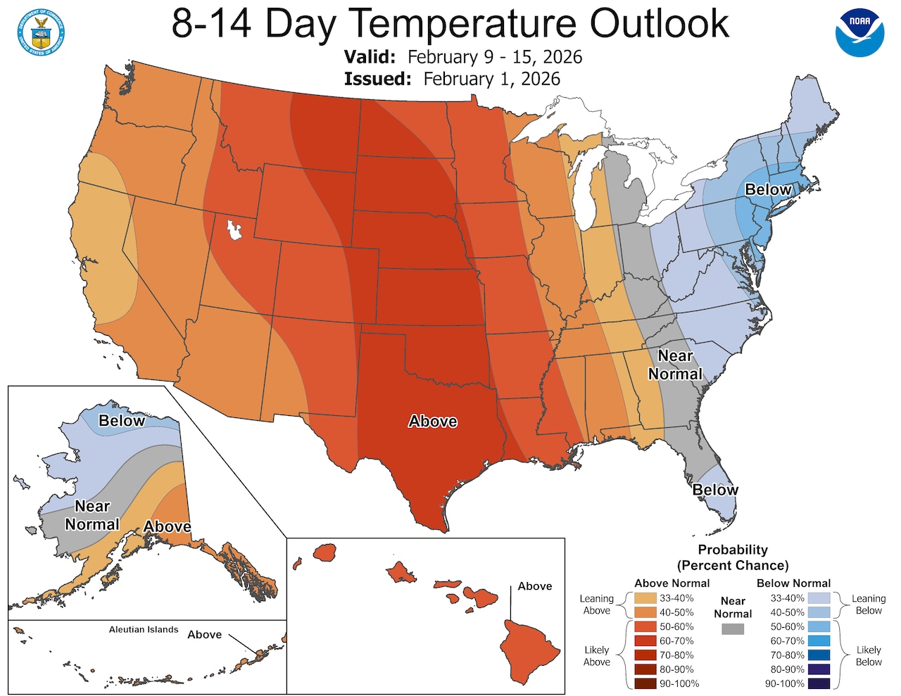
This pattern of temperatures below normal is forecast to continue until at least mid-February and possibly all month, according to the eight-to-14-day and one-month outlooks from the National Oceanic and Atmospheric Administration Climate Prediction Center.
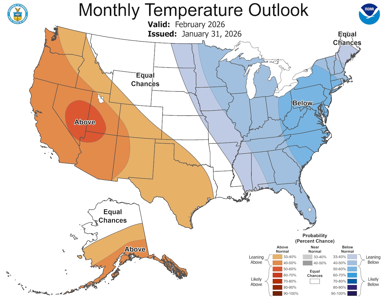 Looking ahead, temperatures are leaning below normal for all of February 2026.National Oceanic and Atmospheric Administration
Jan. 23 marked the last time the NWS recorded a high above the 32-degree freezing point at its Lehigh Valley International Airport climate station. Daytime highs on Tuesday and Wednesday are forecast at 32 and 31, respectively.
The longest streak on record for days at or below freezing in the Lehigh Valley stands at 18, set Jan. 27 to Feb. 13, 1978. Monday was Day 10 of this sub-freezing snap.
The Lehigh Valley’s normal high this time of year is 39, rising to 40 on Feb. 6.
“Looking over the next seven days, we’re going to have a couple of we’ll call them relatively mild days up in the Lehigh Valley,” Lee said Monday. “As we get into especially over the weekend, we’re looking at the potential for another blast of truly cold air.”
Lehigh Valley temperatures are forecast to plummet overnight Friday into Saturday, dipping to around 5, with weekend daytime highs in the mid to upper teens.
This cold stretch has produced myriad impacts: Safe Harbor Easton this past weekend extended hours at its winter shelter for the unhoused to find some relief. The Mid-Atlantic power grid operator PJM Interconnection last week alerted data centers and other large-load customers to a federal order “directing certain customer-owned backup generation facilities to operate under emergency conditions”; that means turning to backup power generation to try and “prevent avoidable blackouts, thereby saving lives and reducing costs to the American people.”
Communities like Bethlehem and Salisbury Township on Monday were dealing with water main breaks. Snow from the Jan. 25 storm has lingered on sidewalks and continued to create problems with parking and travel in some neighborhoods.
There are a few chances for a little more snow Tuesday night into Wednesday morning and again overnight Friday into Saturday, forecasters say.
“It’s not going to be a lot of snow, but it’s enough just to freshen everything up,” Bobby Martrich from the Lehigh Valley-based EPAWA Weather Consulting LLC said in a forecast video Monday. “You have stale snow piles that have been sitting around since last Sunday. And it’s been so cold that it hasn’t been really melting, at least not much. It’s been compacting a little bit but not really melting.”
Why has it been so cold?
With high pressure generally in control over the region, northwest winds have been carrying in Arctic air, Lee from the National Weather Service said Monday.
“Unfortunately we’ve just been kind of stuck in this weather pattern,” she said.
Larger-scale factors also are in play, like the polar vortex descending down over the continental United States.
As far back as October 2025, changes in the Arctic and low sea ice were setting up conditions for the kind of stretched polar vortex that brings severe winter weather to the U.S., said winter weather expert Judah Cohen, an MIT research scientist. Heavy Siberian snowfall added to the push-and-pull of weather that warps the shape of the normally mostly circular air pattern. Those conditions “kind of loaded the dice a bit” for a stretching of the polar vortex, he said.
The Associated Press contributed to this report.