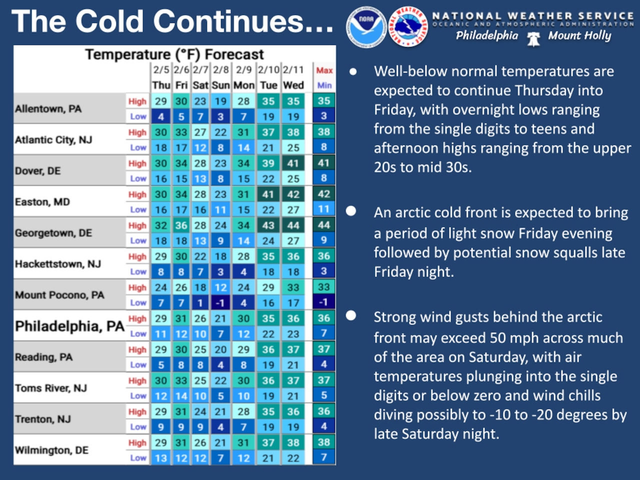
An Arctic front will sweep through the region Friday night, bringing brutally cold air, gusty winds and snow squalls that could create hazardous driving conditions Saturday morning.
The National Weather Service forecasts wind chills to plummet to minus 20 degrees in the southern Poconos, with dangerous wind chills as cold as 15 below zero expected across the Lehigh Valley Saturday night into Sunday morning.
High temperatures around 30 degrees are forecast Thursday and Friday, with clouds building Thursday night. Northwest winds will be calm to 5 mph.
A clipper system will produce light snow beginning Friday evening, with about a half-inch of total accumulation expected.
The more significant threat arrives late Friday night into Saturday morning when the Arctic front passes through.
Snow showers will become likely across most of the area, with some stronger snow showers potentially developing into squalls. These squalls could briefly reduce visibility to under one mile, produce wind gusts up to 40 mph and quickly coat road surfaces, creating slick and hazardous driving conditions.
Saturday will bring the most dangerous cold, with high temperatures likely occurring early in the morning before crashing into the teens by late morning.
Northwest winds will increase to 20 to 30 mph with gusts of 40 to 50 mph, likely prompting wind advisories for the region.
Wind chills Saturday will mostly be in the single digits, with the most extreme conditions in the southern Poconos where wind chills could reach minus 20 degrees.
Saturday night will be even more brutal, with lows dropping from the single digits to minus 5 degrees in the southern Poconos and far northwest New Jersey. Wind chills of around minus 15 are expected in the Lehigh Valley and northern New Jersey, and potentially minus 30 in the southern Poconos.
Arctic air will remain in place Sunday with highs in the teens to low 20s, though winds will diminish, resulting in single-digit wind chills during the day.
Temperatures are forecast to gradually warm as the new work week progresses, providing relief from the extreme cold.
Current weather radar