

The likelihood of snow for eastern Pennsylvania has increased as a winter storm remains on track to impact the Philadelphia region Sunday evening into Monday morning, according to the latest forecasts.
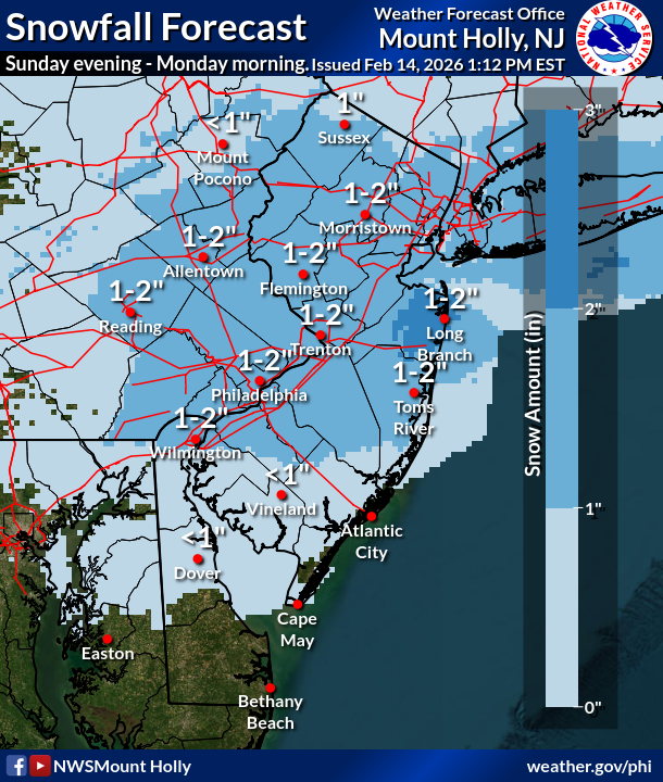
The best chance of snow accumulations will be from near the Interstate 95 and I-195 corridors and north, where 1 inch of snow or more is possible, the National Weather Service in Mt. Holly said in a Saturday afternoon update. Areas south of there are more likely to see rain.
The snow is expected to be wet and slushy, forecasters said, and will likely stick to surfaces, including trees, grass and power lines. Motorists should expect slushy accumulations on roads.
.png)
The chance of snow increased for the Garden State due to the storm’s track shifting north. On Friday, guidance showed only a 15 percent chance of widespread impacts in the Philadelphia region. By Saturday afternoon, those numbers tripled.
“We continue to monitor the low expected to pass to the south of the region Sunday into Monday,” the National Weather Service said. “Details remain uncertain, but primarily rain is expected for the southern coastal plain with potentially some snow for areas further north.”
The heaviest precipitation is anticipated to affect the area on Sunday night, according to the National Weather Service. This precipitation is expected to taper off by Monday morning.
“The big question remains how far north the precipitation gets,” the National Weather Service added.
Here’s a look at the detailed forecast for the Philadelphia region:
Saturday Night: Patchy freezing fog after 2am. Increasing clouds, with a low around 28. Calm wind.
Sunday: A chance of rain, mainly after 3pm. Patchy fog between 9am and 10am. Patchy freezing fog before 9am. Otherwise, cloudy, with a high near 41. Calm wind becoming east around 5 mph. Chance of precipitation is 30%. New precipitation amounts of less than a tenth of an inch possible.
Sunday Night:: Rain likely before 10pm, then snow. Low around 33. Northeast wind 5 to 10 mph. Chance of precipitation is 80%. New snow accumulation of 1 to 2 inches possible.
Monday: Mostly cloudy, with a high near 41. North wind 5 to 10 mph.
Monday Night: Mostly cloudy, with a low around 33. Calm wind.
Tuesday: Partly sunny, with a high near 46.