
A storm system is still likely to bring at least some snow to the Lehigh Valley this weekend, but just how much remains anyone’s guess.
There is still a high amount of variability in what the array of forecast models are showing for the potential winter storm that could impact a large swath of the Mid-Atlantic and Northeast. The storm is expected to form over the Gulf Coast on Saturday before strengthening, according to AccuWeather.
Two possible scenarios are shaping up, according to the National Weather Service’s forecast office in Mount Holly, New Jersey.
In the first scenario, the low pressure system passes well to the south and east of our region, tracking further off the coast. If that happens, we could still get light snow, but accumulations should be low.
However, in the second scenario, the storm tracks closer to the coast. If that occurs, heavier snow is possible, along with high winds, according to the weather service.
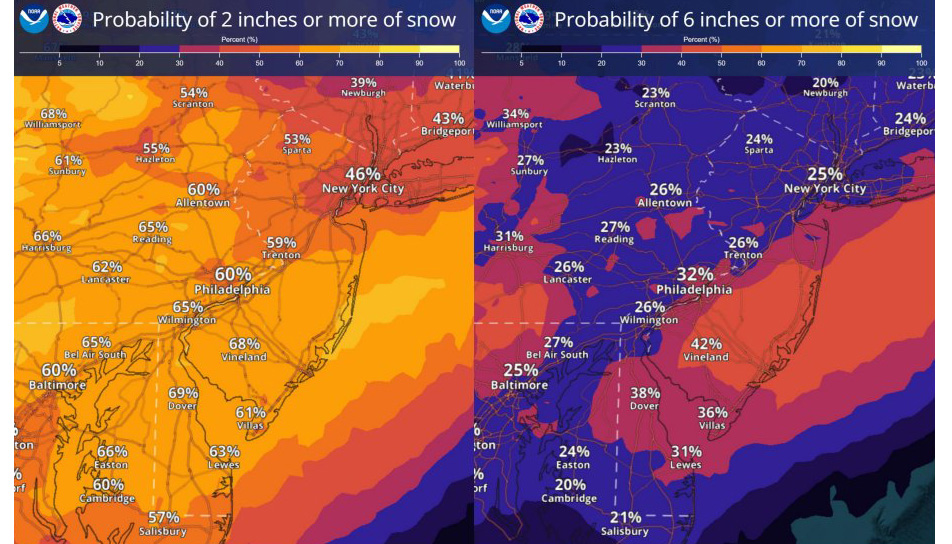
As of late Thursday, the odds favor the Lehigh Valley getting at least some snow, with the region having a 60% chance of seeing at least 2 inches, according to the weather service’s snowfall probability map. However, the chances of a more significant snowfall — 6 inches or more — are much lower at 26%.
AccuWeather was a little more specific in its snowfall forecast, showing much of the Northeast getting between 1 and 3 inches of snow, with some localized areas seeing up to 6 inches.
“The most likely scenario is for the storm to strengthen later and track slightly too far east to bring 6–12 inches of snow to a broad stretch of the I-95 corridor in the Northeast,” AccuWeather forecaster Alex Sosnowski said in a post Thursday.
However, if the second scenario unfolds, the storm “could turn into a nor’easter,” bringing higher snowfall totals, he noted.
“If this scenario plays out, millions could face significant delays during the Monday morning commute,” Sosnowski said.
Whatever precipitation we do get is likely to begin sometime Sunday and continue into Monday, according to the weather service forecast.
After the storm, colder air will settle in over the region through Tuesday. High temperatures in the 30s are expected, a noticeable change from the milder weather this week. Warmer air will return by later next week, according to the weather service.
Here is the extended weather service forecast:
Friday: Rain, mainly before noon. Patchy fog. High near 43. East wind around 10 mph. Chance of precipitation is 100%. New precipitation amounts between a quarter and half of an inch possible.
Friday Night: Cloudy, then gradually becoming partly cloudy, with a low around 34. Calm wind becoming west around 5 mph after midnight.
Saturday: Partly sunny, with a high near 46. West wind around 5 mph.
Saturday Night: A chance of rain and snow after 1 a.m. Mostly cloudy, with a low around 31. Calm wind. Chance of precipitation is 30%. Little or no snow accumulation expected.
Sunday: Snow, possibly mixed with rain. High near 37. Chance of precipitation is 90%. New precipitation amounts between a tenth and quarter of an inch possible.
Sunday Night: Snow likely, mainly before 1 a.m. Cloudy, with a low around 29. Chance of precipitation is 60%.
Monday: A chance of snow before 1 p.m. Mostly cloudy, with a high near 39. Chance of precipitation is 30%.
Monday Night: Mostly cloudy, with a low around 24.
Tuesday: Partly sunny, with a high near 35.
Tuesday Night: Mostly cloudy, with a low around 20.
Wednesday: A chance of rain. Mostly cloudy, with a high near 41. Chance of precipitation is 30%.