

The Lehigh Valley could see up to a foot of snow Sunday into Monday from a storm that may bring blizzard conditions to areas along the Jersey shore, the National Weather Service said Saturday morning.
The region remains under a winter storm watch from 4 a.m. Sunday morning until 6 p.m. Monday.
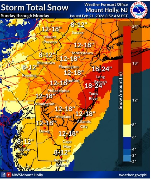 Latest snowfall projections from the National Weather Service in Mount Holly, New Jersey.
As of Saturday morning, the Lehigh Valley is forecast to get between 8 and 12 inches of snow, with areas of the Poconos seeing 12 to 18 inches. Bucks County, where a winter storm warning has been issued, may see 12-18 inches of snow, according to the National Weather Service forecast office in Mount Holly, New Jersey.
A blizzard warning has been issued for areas along the New Jersey and Delaware coasts.
Snow is expected to begin falling Sunday morning. Some areas near and south of Interstate 78 could see rain in the beginning thanks to milder Sunday morning temperatures, the weather service said. The heaviest snowfall will come Sunday evening into Monday morning.
Snow will impact the Monday morning commute, and possibly the Monday evening commute in some areas, forecasters said. Snow covered roads along with reduced visibility from blowing snow will cause widespread travel disruptions, if not downright hazardous conditions.
As has been the case earlier in the week, weather models aren’t entirely in agreement on the track of the storm. Should it stay close to the coast, it’ll bring significant snowfall to the entire region. Another model shows a weaker system staying farther offshore, which would result in far less snow in the Lehigh Valley. However, that model has started to move northwestward, forecasters said, bringing it closer in alignment to others.
“Both outcomes would result in significant accumulating snow across at least some portions of the area,” forecasters said.
Snowfall rates could exceed 2 inches per hour where the heaviest accumulations are forecast. Snow will likely come to an end from west to east sometime Monday afternoon.
The storm also will bring high winds, with gusts of 30-40 mph for inland areas and up to 55 mph along the coast. Wind could lead to downed trees and power outages, the weather service warns.
Here’s the extended forecast:
Saturday: Mostly sunny, with a high near 45. West wind around 5 mph.
Saturday night: A slight chance of rain between 3 and 4 a.m., then a chance of snow. Increasing clouds, with a low around 30. Calm wind. Chance of precipitation is 30%. Little or no snow accumulation expected.
Sunday: Snow, possibly mixed with rain, becoming all snow after 4 p.m. High near 36. Light east wind becoming northeast 10 to 15 mph in the morning. Chance of precipitation is 100%. New snow accumulation of 1 to 2 inches possible.
Sunday night: Snow, heavy at times. Patchy blowing snow after 1 a.m. Low around 28. Blustery, with a north wind 15 to 20 mph. Chance of precipitation is 90%. New snow accumulation of 4 to 8 inches possible.
Monday: Snow likely, mainly before 1 p.m. Areas of blowing snow before 2 p.m. Cloudy, with a high near 36. Breezy, with a north wind around 20 mph, with gusts as high as 30 mph. Chance of precipitation is 60%. New snow accumulation of 1 to 3 inches possible.
Monday night: Mostly cloudy, with a low around 21.
Tuesday: Partly sunny, with a high near 32.
Tuesday night: Mostly cloudy, with a low around 20.
Wednesday: A chance of snow before 1 p.m., then a chance of rain and snow. Mostly cloudy, with a high near 39. Chance of precipitation is 30%.
Wednesday night: A chance of rain. Mostly cloudy, with a low around 31. Chance of precipitation is 40%.
This is a developing story. Check back for updates.