
Strong winds and rain as temperatures drop in Western Pennsylvania
AM showers tomorrow, then falling PM Temps
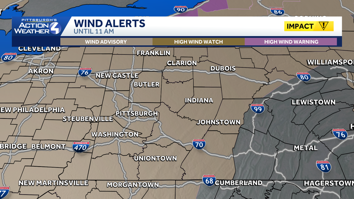
TONIGHT’S GAME BETWEEN VENEZUELA AND ITALY IN THE CHAMPIONSHIP. IT’S AN IMPACT DAY FOR US. IN TYPICAL PITTSBURGH FASHION, WE’RE GETTING ALL FOUR SEASONS. TODAY, WE’RE KICKING IT OFF WITH SOME WARMER TEMPERATURES AND GUSTY WINDS. RIGHT NOW, ABOUT A 25 TO 30 MILE PER HOUR WIND AROUND THE REGION. WE STILL HAVE THIS WIND ADVISORY IN PLACE UNTIL 11 A.M. THIS IS FOR THE ENTIRE AREA BECAUSE AS THIS COLD FRONT SWEEPS THROUGH, WE STILL COULD HAVE GUSTS UP TO 50MPH. WE CAN’T RULE THAT OUT AS WE CONTINUE THROUGH THE MORNING. BEAUTIFUL SHOT HERE OF OUR CITY. CLOUDS ARE STARTING TO THICKEN UP 58 DEGREES RIGHT NOW IN PITTSBURGH AND ALL AROUND THE REGION. IT’S ALL GOING TO BE ABOUT THE WINDY CONDITIONS THIS MORNING. THEN DROPPING TEMPERATURES STILL BREEZY THROUGH THE DAY. WE’LL HAVE THOSE RAIN SHOWERS CHANGING OVER TO A FEW SNOWFLAKES. BUT HERE’S THE LATEST. CURRENTLY, AS THAT RAIN GETS CLOSER AND CLOSER, JUST NOW EDGING INTO BEAVER PARTS OF WASHINGTON EXTENDING UP INTO WESTERN PARTS OF LAWRENCE COUNTY. ALSO INTO MERCER. SEE SOME LINES EMBEDDED HERE? SOME HEAVIER RAIN COULD EVEN HAVE A LITTLE BIT OF LIGHTNING AND A FEW RUMBLES OF THUNDER. THE BIG STORY, THOUGH, AS THIS FRONT MOVES THROUGH, WILL DEFINITELY BE THE GUSTY WINDS THAT WE COULD HAVE A BREAK IN THE ACTIVITY BEFORE ANOTHER WEAK DISTURBANCE OUT NEAR CHICAGO REINFORCES THAT COLD AIR AND KEEP SOME OF THOSE FLAKES IN THE FORECAST. YOU CAN SEE AS IT MOVES INTO THE STATE OF INDIANA, IT IS WEAKENING A LITTLE BIT, BUT OVERALL, WE’RE STILL GOING TO SEE SOME SNOWFLAKES FLYING AROUND TO FINISH OUT THE DAY. LET’S TIME OUT HERE ON FUTURECAST. WE’RE STILL GOING TO HAVE THIS RAIN. NINE 10:00 AS KIDS ARE HEADING OUT TO THE BUS STOP. AS YOU’RE HEADING HOME, HEADING OUT TO WORK, TEMPERATURES ARE STILL VERY MILD, UPPER 50S AND LOW 60S BREAK IN THE ACTIVITY THROUGH A LOT OF THE EARLY AFTERNOON, AROUND THREE 4:00, WE’LL START TO SEE SOME OF THAT RAIN SNOW MIX AS OUR TEMPERATURES CONTINUE TO DROP. SO REALLY BETWEEN 6 AND 9:00 TONIGHT COULD SEE SOME LIGHT ACCUMULATIONS, ESPECIALLY ON THE GRASSY SURFACES. KEEP IN MIND THE GROUND TEMPERATURE STILL RELATIVELY WARM. WE’RE GOING TO HAVE THAT COLD AIR IN PLACE TOMORROW MORNING. WAKING UP IN THE 20S. WIND CHILLS INTO THE TEENS. WE’RE STILL GOING TO SEE THOSE PESKY FLAKES FLYING AROUND ON OUR SAINT PATRICK’S DAY. SO HERE’S HOW MUCH SNOW WE’RE LOOKING AT. THIS IS 5:00 AGAIN. START TO SEE A LIGHT DUSTING DOWN INTO FAYETTE AND GREENE COUNTY, BUT CAN’T RULE OUT UP TO AN INCH. NOW KEEP IN MIND THE GROUND IS STILL PRETTY WARM. WHERE WE’RE REALLY SEEING IT STICKING IS INTO THOSE HIGHER ELEVATIONS EAST. AND THAT IS WHERE WE DO HAVE A WINTER WEATHER ADVISORY IN PLACE. EASTERN PORTIONS OF WESTMORELAND, FAYETTE, CAMBRIA, SOMERSET DOWN INTO GARRETT COUNTY. IT STARTS AT 5:00 TONIGHT UNTIL 5 P.M. ON TUESDAY. LOOKING AT YOUR FOUR DAY PLUS FOR MORE FORECAST, WE’RE DEFINITELY GETTING INTO THE SPRING SEASON. IT’S OFFICIALLY SPRING ON FRIDAY RIGHT NOW. DOESN’T LOOK TOO BAD. WE’
Strong winds and rain as temperatures drop in Western Pennsylvania
AM showers tomorrow, then falling PM Temps

Updated: 8:36 AM EDT Mar 16, 2026
Monday is an Impact Day for a line of showers early to mid-morning, windy conditions through the day and falling temperatures in the afternoon with some light snow.Wind AdvisoryA Wind Advisory is in place for the entire region until 11 am. Wind gusts could peak up to 50 mph, especially as a cold front passes this morning.Impact Day with rain, snow, & falling tempsToday is an impact day with an approaching cold front that will bring rain showers and gusty winds for part of the morning commute. Temperatures will slowly drop through the day and as we approach the evening commute light snow showers will settle in late this afternoon and continue through the overnight.Temperatures fall from the 60s this morning to the 40s by late afternoon. Any leftover moisture could be squeezed out some light snow/flurries. A light dusting up to an inch of accumulation is possible with higher amounts in the higher elevations east where they have a winter weather advisory in place from 5pm tonight through 5pm, Tuesday.Much colder St. Patrick’s Day, counting down to springTuesday will be the coldest day of the week with temperatures hovering near freezing and a brisk northwest wind. Morning wind chills will be in the teens and it will only feel like the low 20s by the afternoon. Temperatures will gradually improve by next weekend. Spring officially begins at 10:46 a.m. Friday.TODAY – Impact Day: AM Showers. Windy with falling PM temperatures. Morning high of 62°, Low 40s by 4pm.TUESDAY: Mostly cloudy. Brisk and cold. Isolated flurries. High: 30°WEDNESDAY: Partly sunny. Not as cold. High: 41°
Monday is an Impact Day for a line of showers early to mid-morning, windy conditions through the day and falling temperatures in the afternoon with some light snow.
Wind Advisory
A Wind Advisory is in place for the entire region until 11 am. Wind gusts could peak up to 50 mph, especially as a cold front passes this morning.
Impact Day with rain, snow, & falling temps
Today is an impact day with an approaching cold front that will bring rain showers and gusty winds for part of the morning commute. Temperatures will slowly drop through the day and as we approach the evening commute light snow showers will settle in late this afternoon and continue through the overnight.
Temperatures fall from the 60s this morning to the 40s by late afternoon. Any leftover moisture could be squeezed out some light snow/flurries. A light dusting up to an inch of accumulation is possible with higher amounts in the higher elevations east where they have a winter weather advisory in place from 5pm tonight through 5pm, Tuesday.
Much colder St. Patrick’s Day, counting down to spring
Tuesday will be the coldest day of the week with temperatures hovering near freezing and a brisk northwest wind. Morning wind chills will be in the teens and it will only feel like the low 20s by the afternoon. Temperatures will gradually improve by next weekend. Spring officially begins at 10:46 a.m. Friday.
TODAY – Impact Day: AM Showers. Windy with falling PM temperatures. Morning high of 62°, Low 40s by 4pm.
TUESDAY: Mostly cloudy. Brisk and cold. Isolated flurries. High: 30°
WEDNESDAY: Partly sunny. Not as cold. High: 41°