
Pittsburgh: Warming up into Spring this weekend
A couple of chances at rain accompany the warmup.
THE BUILDING. WE’RE IN THE LAST BLAST HERE OF WINTER AS WE SAY GOODBYE TO WINTER TOMORROW, AS WE’LL START WARMING UP. IT’S GOING TO BE A COLD DAY. WE’RE HEADING IN THE RIGHT DIRECTION. WE’RE BACK TO THE 50S ON THURSDAY. WE’LL WATCH FOR SHOWER CHANCE LATE IN THE DAY. AND THEN FRIDAY WE OFFICIALLY WELCOME IN SPRING. IT’S AT 1046 IN THE MORNING AND WE’LL KEEP WARMING INTO THE WEEKEND AS WELL. STILL SOME SCATTERED SNOW SHOWERS ACROSS WESTERN PENNSYLVANIA. THESE ARE VERY FEW AND FAR BETWEEN AND DECREASING IN COVERAGE. AND THAT TREND WILL CONTINUE. BUT UNTIL WE GET PAST SUNSET. IF YOU ARE HEADING OUTSIDE, BE AWARE YOU MAY COME UNDERNEATH ONE OF THESE POCKETS OF HEAVIER SNOW. AND THE MAIN CONCERN IS REDUCING VISIBILITY. SO IF YOU ARE DRIVING. JUST SOMETHING TO KEEP IN MIND. WE START AT 16. TOMORROW WE WILL FINISH AT 38 DEGREES. WE’LL MAKE IT TO 53 ON THURSDAY. WE ARE WATCHING FOR RAIN CHANCE LATE IN THE DAY AS RAIN SHOWERS OVERSPREAD THE AREA, LIKELY AS WE GET PAST THE EVENING COMMUTE. WE’LL PAUSE FUTURECAST HERE AT 7:00. WE’LL LIKELY SEE OUR MOST WIDESPREAD RAIN SHOWERS ACROSS WESTERN PENNSYLVANIA, BUT THIS IS A QUICK MOVING SYSTEM. AS WE GET CLOSER TO MIDNIGHT, THOSE RAIN SHOWERS ARE GONE AND THIS SYSTEM IS NOT REALLY GOING TO USHER IN COLDER AIR. WE GET WARMER ON FRIDAY. WE’RE UP TO 5660 DEGREES FOR US ON SATURDAY. SUNDAY WILL WATCH FOR ANOTHER SYSTEM TO ARRIVE. QUESTIONS ON TIMING. WITH THIS ONE, WE SHOULD MAKE IT TO 64 DEGREES BEFORE RAIN CHANCES GET HERE, BUT THERE’S REALLY TWO WINDOWS OF TIME WE’RE WATCHING. ONE WOULD BE AS EARLY AS ABOUT MID-AFTERNOON, THE OTHER ONE WOULD BE LATER IN THE DAY, PERHAPS AFTER SUNSET LASTING INTO EARLY ON MONDAY MORNING. SO WE’LL WATCH THE TIMING WITH THIS. THIS WILL BRING ANOTHER ROUND OF RAIN SHOWERS, AND THIS WILL DROP OUR TEMPERATURES HEADING INTO NEXT WEEK. WE’RE IN THE 40S MONDAY AND TUESDAY, BUT WE ARE BACK INTO THE 50S WITH LOTS OF SUNSHINE AS WE HEAD INTO NEXT WEDNESDAY. IF YOU’RE NOT SEEING THOSE SNOW SHOWERS OUT THERE, SUNSHINE IS POKING THROUGH, BUT YOU CAN SEE ON THE WALL WHERE SOME OF THOSE SNOW SHOWERS ARE HERE ON ACTION CAM TEMPERATURE OF 23 AT PITTSBURGH INTERNATIONAL. IT’S STILL BREEZY. WINDS ARE NORTHWEST AT 24, SO IT FEELS LIKE IT IS SEVEN DEGREES OUTSIDE. THE GOOD NEWS AS THE SNOW SHOWERS TAPER OFF, THE WIND WILL ALSO DIE DOWN, SO WIND CHILL. NOT A MAJOR CONCERN. TOMORROW WE ARE STARTING IN THE TEENS. WE WILL FINISH IN THE 30S AS WE HEAD THROUGH THE AFTERNOON AND AGAIN WE ARE HEADING IN THE RIGHT DIRECTION. TEMPERATURES WILL WARM FOR THE REST OF THE WEEK. WE’LL MAKE IT INTO THE 60S THIS WEEKEND. DESPITE TWO CHANCES OF RAIN, ONE
Pittsburgh: Warming up into Spring this weekend
A couple of chances at rain accompany the warmup.

Updated: 8:47 PM EDT Mar 17, 2026
The wintry conditions and feeling will go by the wayside Thursday.Temperatures moderate into springThe cold air lingers tomorrow. After starting in upper teens, Wednesday’s high will rally into the upper 30s. Temperatures will continue to improve through the weekend. All of this in time for spring. The Vernal Equinox is at 10:46 a.m. Friday. Highs for the first weekend of spring will in the 60s.A few rain shower chancesA quick clipper will usher in a few late-day rain showers on Thursday. Rain looks to arrive after the evening commute and likely end before we get to midnight Friday. We are watching another system to arrive late in the weekend. Another quick-moving cold front looks to arrive on Sunday with a few more showers. Temperatures get knocked back into the 40s early next week.TONIGHT: Snow ends, some clearing. Low: 16°.WEDNESDAY: Mostly cloudy with late-day flurries east. High: 38°, low: 32°.THURSDAY: More clouds than sun with evening rain showers possible. High: 53°, low: 37°.FRIDAY: Partly cloudy and milder. High: 56°, low: 40°.
PITTSBURGH —
The wintry conditions and feeling will go by the wayside Thursday.
Temperatures moderate into spring
The cold air lingers tomorrow. After starting in upper teens, Wednesday’s high will rally into the upper 30s. Temperatures will continue to improve through the weekend. All of this in time for spring. The Vernal Equinox is at 10:46 a.m. Friday. Highs for the first weekend of spring will in the 60s.

Hearst OwnedHearst
A gradual warm up takes us into spring later this week.
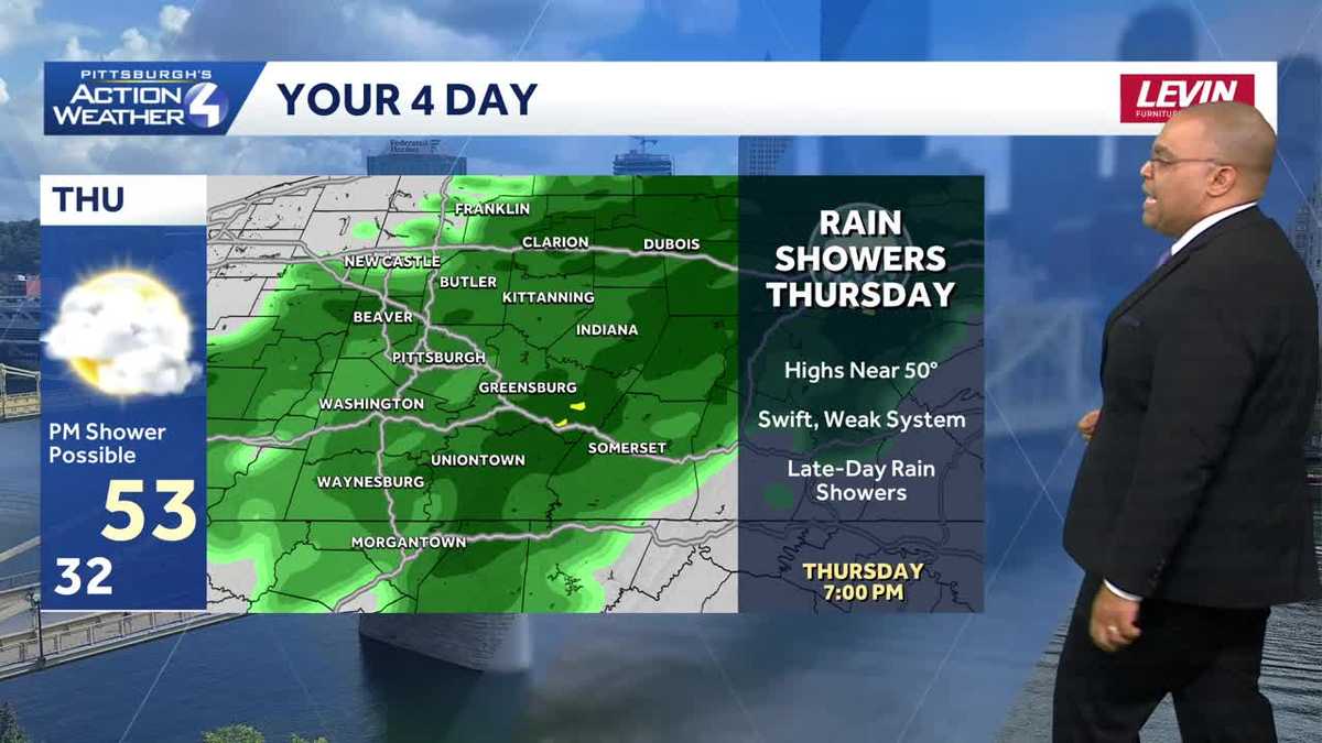
A few rain shower chances
A quick clipper will usher in a few late-day rain showers on Thursday. Rain looks to arrive after the evening commute and likely end before we get to midnight Friday.

Hearst Owned
Rain showers return late Thursday to Western PA.
We are watching another system to arrive late in the weekend. Another quick-moving cold front looks to arrive on Sunday with a few more showers. Temperatures get knocked back into the 40s early next week.

Hearst Owned
A nice first weekend of spring with highs in the 60s. Rain showers are possible on Sunday followed by cooler air next week.
TONIGHT: Snow ends, some clearing. Low: 16°.
WEDNESDAY: Mostly cloudy with late-day flurries east. High: 38°, low: 32°.
THURSDAY: More clouds than sun with evening rain showers possible. High: 53°, low: 37°.
FRIDAY: Partly cloudy and milder. High: 56°, low: 40°.