
Western PA: Warming up ahead of spring’s arrival
All dry today. A quick late-day round of rain showers is on tap for Thursday.
TO WATER DAMAGE ALL AROUND THE BUILDING. JOE, THE FORECAST FINALLY COMING OUT OF WINTER TO ALL IN TIME FOR THE FIRST DAY OF SPRING ON FRIDAY. STILL ONE MORE CHILLY DAY TO GET THROUGH. AND AS WE WARM THINGS UP. ALSO SOME RAIN CHANCES COME INTO VIEW. WE’LL SEE SOME ISOLATED ACTIVITY TOMORROW. BETTER CHANCE WILL COME IN MORE THAN LIKELY FRIDAY NIGHT INTO THE START OF THE WEEKEND. DON’T LOVE TALKING ABOUT THIS. TEMPERATURES STARTING OFF IN THE TEENS THIS MORNING. JUST TEN IN BEAVER FOR BUTLER. ALSO AS WE HOP UP TOWARDS DUBOIS ALSO WAYNESBURG THIS MORNING 15 ACROSS ALLEGHENY COUNTY BETWEEN PITTSBURGH AND MONROEVILLE. ALSO MID TEENS FOR GREENSBURG AND MORGANTOWN. AS YOU START OFF THE DAY BREAKING DOWN THE NEXT 12 HOURS, NOT ONLY ARE YOU LAYERING UP IN YOUR WINTER GEAR GEAR, YOU’LL ALSO WANT TO GRAB THE SUNGLASSES. WE’LL INTRODUCE SOME SUNSHINE EARLY IN THE DAY AS THE EARLY SUNLIGHT BOUNCES OFF OF A LITTLE BIT OF SNOW. COULD BE A LITTLE BLINDING. A LITTLE EXTRA SUN GLARE HERE AS WE GET THE DAY STARTED THROUGH THE AFTERNOON. CLOUDS WILL TAKE OVER, BUT THAT WON’T SLOW DOWN OUR WARMING TREND AS TEMPERATURES WILL CLIMB ABOVE THE FREEZING MARK EVEN SEVERAL DEGREES ABOVE THAT. SO NO NEW SNOW TODAY. WE KEEP RAIN CHANCES AT BAY UNTIL MORE THAN LIKELY LATE TOMORROW AFTERNOON, AND EVEN THAT THE COVERAGE NOT ALL THAT IMPRESSIVE. MORE RAIN THOUGH, COMES MARCHING IN FRIDAY, ESPECIALLY LATE INTO THE START OF SATURDAY. AND EVEN STILL, WE COULD CLOSE OUT THE WEEKEND WITH SOME RAIN CHANCES, BUT I WOULDN’T CONSIDER THE WEEKEND A WASHOUT BY A LONG STRETCH. AS WE FAST FORWARD INTO YOUR THURSDAY, WE WILL SEE PLENTY OF CLOUDS AROUND IN THE MORNING, MORE THAN LIKELY AROUND THE LUNCH HOUR, MAYBE A FEW HIT OR MISS, VERY LIGHT RAIN SHOWERS, BUT REALLY NOT A WHOLE LOT TO WRITE HOME ABOUT THAT SHOULD BE FIZZLING OUT IN TIME FOR THE EVENING COMMUTE. WE KEEP THINGS DRY THROUGH THE FIRST DAY OF OUR FIRST PART OF FRIDAY, WHICH IS ALSO THE FIRST DAY OF SPRING AROUND SCHOOL DISMISSAL TIME, EVEN THE START OF THE EVENING COMMUTE. A FEW VERY ISOLATED SHOWERS COULD BE DEVELOPING WELL NORTH OF THE CITY OF PITTSBURGH. MORE THAN LIKELY THE SKIES OPEN UP FRIDAY NIGHT INTO THE OVERNIGHT HOURS THROUGH THE START OF SATURDAY, SO WE’LL CONTINUE TO MONITOR THE TIMING OF THAT. SHOULD BE ABLE TO DRY THINGS OUT IN TIME FOR THE MAJORITY OF THE WEEKEND. ACTUALLY LOOKS PRETTY GOOD. TEMPERATURES, OF COURSE ARE WARMING UP HERE. WE’RE IN THE LOWER 50S ON THURSDAY, SPEEDING AHEAD TO 57 ON FRIDAY, 61 SATURDAY. AND AGAIN, THAT WOULD ALL BE DEPENDENT ON HOW FAST WE CAN GET THE RAIN TO MOVE OUT. AS WE LOOK AHEAD TO SUNDAY. THAT’S THE THIRD SYSTEM IN OUR SERIES. CAN WE BRING US BETTER OPPORTUNITY FOR SHOWERS? LOOKS LIKE LATE IN THE DAY INTO EARLY MONDAY MORNING. WE’LL CONTINUE TO MONITOR THAT SET UP, AS WE MAY NEED TO INTRODUCE AN IMPACT DAY IF THOSE SHOWERS DO HAPPEN TO LINGER INTO THE MONDAY MORNING DRIVE BEHIND THAT RAIN THOUGH LATE IN THE WEEKEND, TEMPERATURES WILL DROP BACK OFF ONLY UPPER 40S MONDAY, BUT IT’S NICE TO SEE. WE’LL STRING TOGETHER SEVERAL DAYS OF SUNSHINE. TEMPERATURES IN THE LOW TO MID 50S ARE ALSO EYEING A GOOD AMOUNT OF SUNSHINE THROUGH THE MIDDLE PART OF NEXT WEEK, SO HOPEFULLY ONCE SPRING OFFICIALLY BEGINS ON FRIDAY, THE SIGNAL TO PATTERN CHANGE HERE IN WESTERN PENNSYLVANIA. I THINK A LOT O
Western PA: Warming up ahead of spring’s arrival
All dry today. A quick late-day round of rain showers is on tap for Thursday.

Updated: 5:28 AM EDT Mar 18, 2026
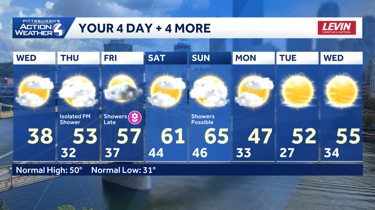
Spring is just around the corner, and milder temperatures are about to return to western Pennsylvania. Highs crack freezing this afternoon. A string of the 50s and 60s will extend through the weekend. A few rain chances are on the way too.Shaking off winterThe cold air lingers for one more day. After starting in teens, today’s high will rally into the upper 30s. Peeks of morning sunshine will give way to more clouds this afternoon. Temperatures will continue to improve through the weekend. All of this in time for spring! The Vernal Equinox is at 10:46 a.m. Friday. Highs over the weekend will in the 60s.A few rain chances through the weekendA quick and weak clipper will usher in more clouds and isolated afternoon rain showers tomorrow. The rain will fizzle before midnight.A second systems slips through the Pittsburgh area late Friday. We are watching a final disturbance system arriving late in the weekend.Seasonably cool but dry next weekTemperatures get knocked back into the 40s early next week. The pattern will quiet down with a string of sunny days.TODAY: Peeks of morning sunshine, afternoon clouds. Still cold, high: 38°.TONIGHT: Cloudy and chilly. Low: 32°.THURSDAY: Milder and mostly cloudy. Afternoon showers. High: 53°, low: 37°.FRIDAY: More clouds than sun with late-day showers. High: 57°, low: 44°.SATURDAY: Partly to mostly cloudy and mild. High: 61°, low: 46°.
PITTSBURGH —
Spring is just around the corner, and milder temperatures are about to return to western Pennsylvania. Highs crack freezing this afternoon. A string of the 50s and 60s will extend through the weekend. A few rain chances are on the way too.
Shaking off winter
The cold air lingers for one more day. After starting in teens, today’s high will rally into the upper 30s. Peeks of morning sunshine will give way to more clouds this afternoon. Temperatures will continue to improve through the weekend.

Hearst OwnedHearst
Not as cold today with temperatures climbing above freezing under partly sunny skies.
All of this in time for spring! The Vernal Equinox is at 10:46 a.m. Friday. Highs over the weekend will in the 60s.
A few rain chances through the weekend
A quick and weak clipper will usher in more clouds and isolated afternoon rain showers tomorrow. The rain will fizzle before midnight.

Hearst OwnedHearst
More clouds and isolated showers on Thursday. Two more systems will push showers our way late Friday and Sunday.
A second systems slips through the Pittsburgh area late Friday. We are watching a final disturbance system arriving late in the weekend.
Seasonably cool but dry next week
Temperatures get knocked back into the 40s early next week. The pattern will quiet down with a string of sunny days.

Hearst OwnedHearst
Warming up in time for the early days of spring. Temperatures will turn seasonably cool for western PA early next week.
TODAY: Peeks of morning sunshine, afternoon clouds. Still cold, high: 38°.
TONIGHT: Cloudy and chilly. Low: 32°.
THURSDAY: Milder and mostly cloudy. Afternoon showers. High: 53°, low: 37°.
FRIDAY: More clouds than sun with late-day showers. High: 57°, low: 44°.
SATURDAY: Partly to mostly cloudy and mild. High: 61°, low: 46°.