
Springlike weekend with strong storms late Sunday for south-central Pennsylvania
Saturday ends on a mild & pleasant note. Sunday will be warmer with a chance of late evening storms. Some may be strong to severe.
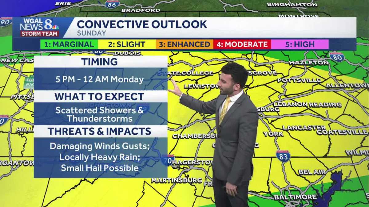
SUNDAY AFTERNOON. I’M JENN SULLIVAN REPORTING NOW, THE W G A L NEWS EIGHT STORM TEAM FORECAST WITH METEOROLOGIST RYAN ARGENTINA. TOMORROW IS AN IMPACT EVENING FOR THE SUSQUEHANNA VALLEY. AS WE GET INTO OUR SUNDAY, YOU CAN SEE WE ARE AT A LEVEL TWO OUT OF FIVE SEVERE WEATHER RISK. NOW THIS IS WHAT’S KNOWN AS THE CONVECTIVE OUTLOOK. THAT’S THAT’S THAT’S USUALLY ISSUED BY THE STORM PREDICTION CENTER. THAT KIND OF HIGHLIGHTS THE INTENSITY OF THE, OF THE POTENTIAL THUNDERSTORMS THAT MAY COME INTO PLAY AS WE HEAD INTO TOMORROW. SO LET’S TALK ABOUT THE TIMING HERE. WE’RE GOING TO GET RIGHT INTO IT. 5 P.M. UNTIL 12 A.M. MONDAY. WE ORIGINALLY HAD 11:00 PM TOMORROW NIGHT, BUT I DID LOOK AT THE RECENT DATA. I DO THINK I’M GOING TO EXTEND THAT BY ANOTHER HOUR TO ACCOUNT FOR ANY RESIDUAL SEVERE ACTIVITY. SO I’M SAYING 12 A.M. MONDAY FOR AS WE GET INTO TOMORROW. BUT WHAT TO EXPECT? SCATTERED SHOWERS AND THUNDERSTORMS. THUNDERSTORMS COULD BE STRONG TO SEVERE WITH SOME OF THESE. SOME OF THE STRONGER STORMS. BUT THE MAIN THREATS TO BE CONCERNED ABOUT ARE GOING TO BE THE DAMAGING WIND GUSTS, SOME LOCALLY HEAVY RAIN AND ALSO SOME SMALL HAIL COULD BE POSSIBLE. OR WE COULD SEE SOME HAIL EXCEED THAT ONE INCH MARK. SO THAT’S ONE OF THE CONCERNS HERE AS WE GET INTO TOMORROW. SO HERE’S A HERE’S ANOTHER DETAILED GRAPHIC HERE FOR YOU TO BE ABLE TO KIND OF TAKE A PICTURE WITH HERE. IT’S A LOW TO MODERATE RISK FOR DAMAGING WINDS. LARGE HAIL IS LOW, FLOODING IS LOW AND A VERY LOW TORNADO THREAT FOR THE AFTERNOON. GETTING INTO THE EVENING, IT’S MAINLY TOWARDS LATER IN THE EVENING. WE’LL CHAT ABOUT THAT HERE IN JUST A SECOND. BUT WE’RE STARTING TO SEE SOME OF THOSE CLOUDS BEGIN TO ROLL IN. WE DID HAVE SOME MAINLY CLEAR CONDITIONS, BUT WE’RE STARTING TO SEE SOME CLOUDS ROLL THROUGH TEMPERATURES RIGHT INTO THE LOWER 50S FOR THE RED ROSE CITY, TEMPERATURES HIT RIGHT AROUND 59 DEGREES AT HARRISBURG INTERNATIONAL AIRPORT 53 IS WHAT WE EXPECT FOR THIS TIME OF THE YEAR, SO SLIGHTLY ABOVE AVERAGE FOR FOR MARCH STANDARDS. DIDN’T GET ANY RAINFALL REPORTED ON THE LATEST CLIMATOLOGICAL REPORT. SO FORECAST FOR THE REST OF THIS EVENING WE’LL EXPECT TO SEE INCREASING CLOUDS STILL REMAINING MILD THOUGH, FOR THIS TIME OF THE YEAR, 50 TO 54 DEGREES WILL BE OUR TEMPERATURE RANGE LATER ON. WE’LL STILL HAVE THOSE LIGHT WINDS FROM THE NORTH TURNING EAST AROUND FIVE MILES PER HOUR, THEN WILL BE MOSTLY CLOUDY FOR THE OVERNIGHT PERIOD. STILL MILD FOR MARCH 40TH 2 TO 46 DEGREES. AND WE’LL HAVE THAT WINDS CONTINUE TO SHIFT FROM THE SOUTH BETWEEN 5 AND 10MPH. THEN HERE COMES TOMORROW. NOW LET ME MAKE A NOTE OF THIS. SO IF YOU HAPPEN TO HAVE ANY PLANS FOR TOMORROW, WE’RE GOING TO START WITH SOME SUNSHINE. MAJORITY OF THE DAY STAYS DRY. SO THAT IS THE GOOD NEWS. IF YOU HAPPEN TO HAVE PLANS, YOU’RE GOING TO BE OKAY UNTIL WE GET INTO LATER IN THE EVENING WHERE WE’RE GOING TO SEE THAT SCATTERED THUNDERSTORMS, CHANCE WILL START TO COME IN AGAIN. THAT TIMING IS GOING TO BE FROM 5 P.M. TO 12 A.M. MONDAY. SO THAT’S THAT’S THAT TIMING THERE. SO IT’S AN IMPACT EVENING, NOT A WHOLE IMPACT DAY, BUT IT’S JUST FOR THE EVENING TIME. I WANTED TO EMPHASIZE ON THAT. BUT TEMPERATURES GETTING INTO THE MID 70S, POTENTIALLY RIGHT AROUND 76 DEGREES IS WHAT WE’RE EXPECTING FOR THE AFTERNOON TEMPERATURES INTO THE 50S. NOW WE’RE 59 IN YORK, HARRISBURG AND CARLISLE INTO THE 60S FOR GETTYSBURG AND CHAMBERSBURG. NOW I DO SEE I HAVEN’T GOTTEN ANY RAIN REPORTS FROM LEBANON AND LANCASTER COUNTIES, BUT I DO THINK THIS IS VIRGA THAT’S MOVING THROUGH ON OUR STORM TEAM, LIVE RADAR NETWORK, WHICH IS BASICALLY RAIN THAT FALLS FROM THE CLOUD AND ENDS UP EVAPORATING ON ITS WAY DOWN. SO YOU’RE NOT YOU’RE NOT SEEING ANY PRECIPITATION MAKE IT TO THE GROUND. SO TIMING IT ALL OUT FOR YOU. SO WE’LL GO INTO OUR SUNDAY MORNING. IF YOU HAVE SUNDAY MORNING SERVICES, EVERYTHING IS DRY. SEEING A LITTLE BIT OF SOME SUNSHINE, BUT ALSO SEEING SOME CLOUDS, BEGINNING TO MOVE IN. AND THEN ONCE WE GET INTO THE EARLY AFTERNOON, WE’RE STILL DRY. OKAY. BUT ONCE WE GET INTO LATER IN THE EVENING, RIGHT AROUND 6:00, LOOK AT THIS. HERE COMES THAT RAIN STARTING TO COME IN. YOU SEE SOME OF THOSE REDS STARTING TO MOVE THROUGH LATER INTO THE EVENING. 930 10:00 STILL SEEING THAT SEVERE THREAT PROMINENT. AND BY THE TIME WE GET TO ABOUT 1130 12 A.M., WE’RE STILL SEEING THAT LINE OF SOME STORMS MOVING THROUGH THAT SCATTERED SEVERE THUNDERSTORM ACTIVITY. THEN IN THE WAKE OF THAT COLD FRONT, THAT’S THAT’S ALLOWING THIS TO, TO BE ABLE TO HAPPEN, WE’RE GOING TO SEE SOME LINGERING MORNING SHOWERS AS WE HEAD INTO OUR MONDAY MORNING. SO IN TERMS OF THE TEN DAY FORECAST, WE’LL SEE THAT MORNING SHOWER, MORNING SHOWER CHANCE FOR MONDAY BREEZY FOR YOUR TUESDAY, SEASONABLE FO
Springlike weekend with strong storms late Sunday for south-central Pennsylvania
Saturday ends on a mild & pleasant note. Sunday will be warmer with a chance of late evening storms. Some may be strong to severe.

Updated: 6:41 PM EDT Mar 21, 2026
Saturday ends as a mild & pleasant evening across the Valley. Temperatures will lower through the lower 50s heading into early tonight. Cloud cover will continue increasing heading through the remainder of the evening and lead to mostly cloudy skies overnight. Lows will drop to the lower 40s range.Sunday will feature morning sunshine, then increasing clouds and warmer highs in the lower to mid 70s. Scattered showers and thunderstorms are expected along a cold front during the evening on Sunday, especially along and south of the Pennsylvania Turnpike. The Storm Prediction Center has highlighted the Susquehanna Valley as at risk for a few strong thunderstorms. Damaging straight-line wind gusts will be the main concern. Some areas may also see some small hail. Due to the threat of severe storms, the News 8 Storm Team has made Sunday evening an Impact period.However, the strength of the storms will depend on the amount of instability (thunderstorm fuel) available at the time of development. The lack of instability may prevent storms from reaching their fuel potential and remain under severe limits. In this case, we will see just some showers and rumbles of thunder.Some of this rain lingers into early Monday before tapering completely by mid-morning. Areas south & east of Harrisburg may see some showers linger into the morning commute before tapering off. Showers end completely for everyone by the afternoon. Estimated rainfall from Sunday night to Monday morning looks to be between a quarter and a half an inch. Then we’ll see some clearing Monday afternoon and highs in the upper 40s to lower 50s along with a stiff northwest breeze. Quite a change!Highs will reach the upper 40s to lower 50s on Tuesday, and lower to mid 50s are likely. Both days are forecast to be dry with mostly sunny to partly sunny skies.Temperatures climb to the upper 50s on Thursday, then a chance of showers returns late Thursday into Friday.Temperatures will cool to the upper 40s to near 50 degrees for the following weekend.Have a great rest of your Saturday!
Saturday ends as a mild & pleasant evening across the Valley. Temperatures will lower through the lower 50s heading into early tonight. Cloud cover will continue increasing heading through the remainder of the evening and lead to mostly cloudy skies overnight. Lows will drop to the lower 40s range.
Sunday will feature morning sunshine, then increasing clouds and warmer highs in the lower to mid 70s. Scattered showers and thunderstorms are expected along a cold front during the evening on Sunday, especially along and south of the Pennsylvania Turnpike. The Storm Prediction Center has highlighted the Susquehanna Valley as at risk for a few strong thunderstorms. Damaging straight-line wind gusts will be the main concern. Some areas may also see some small hail. Due to the threat of severe storms, the News 8 Storm Team has made Sunday evening an Impact period.
However, the strength of the storms will depend on the amount of instability (thunderstorm fuel) available at the time of development. The lack of instability may prevent storms from reaching their fuel potential and remain under severe limits. In this case, we will see just some showers and rumbles of thunder.
Some of this rain lingers into early Monday before tapering completely by mid-morning. Areas south & east of Harrisburg may see some showers linger into the morning commute before tapering off. Showers end completely for everyone by the afternoon. Estimated rainfall from Sunday night to Monday morning looks to be between a quarter and a half an inch. Then we’ll see some clearing Monday afternoon and highs in the upper 40s to lower 50s along with a stiff northwest breeze. Quite a change!
Highs will reach the upper 40s to lower 50s on Tuesday, and lower to mid 50s are likely. Both days are forecast to be dry with mostly sunny to partly sunny skies.
Temperatures climb to the upper 50s on Thursday, then a chance of showers returns late Thursday into Friday.
Temperatures will cool to the upper 40s to near 50 degrees for the following weekend.
Have a great rest of your Saturday!