
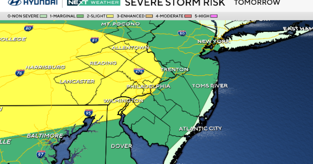
Severe weather potential ramps up Sunday afternoon into the evening as showers and thunderstorms develop from northwest to southeast, with the greatest risk roughly between 4:00 p.m. and 10:00 p.m.
The main threats look to be damaging wind gusts and some large hail, especially from about the I-95 corridor north and west, though a brief isolated severe storm cannot be ruled out elsewhere.

CBS News Philadelphia
Heavy downpours may also lead to localized flooding in urban areas. By late Sunday night into Monday midday, a strong cold front clears the region, ending the storms and bringing gusty winds with falling temperatures through the day.
NEXT big weather change
A severe threat Sunday afternoon/evening through Monday morning is our Next Big Change. A clipper type system will pull a strong cold front across the region.

CBS News Philadelphia
A few strong to severe storms could develop with heavy rain, hail, and isolated damaging winds. The tornado threat is currently low.
Behind the cold front we drop 20 degrees to the low 50’s Monday and Tuesday.
Early forecast for Phillies home opener
The Phillies kick off the season Thursday vs. the Texas Rangers.
Fans can expect mostly cloudy skies and mild with temperatures in the mid-60’s at first pitch.
Cloudy and near 60 at the final out. Rain is possible later that night with winds from the southwest at 10-15 mph.
Here’s your 7-day forecast:

CBS News Philadelphia
Sunday: NEXT Weather Alert for late storms. High 73, low 44.
Monday: NEXT Weather Alert for a.m. storms. High 53, low 50.
Tuesday: Sunny and chilly. High 50, low 32.
Wednesday: Cloud, some sun. High 58, low 36.
Thursday: Mostly cloudy. High 68, low 46.
Friday: Clouds, some sun. High 55, low 52.
Saturday: Partly cloudy. High 48, low 31.