
Western PA: Alert Day for scattered severe thunderstorms
Along with the storm threat, heavy rain could lead to localized flooding.
YOU CAN REGISTER ONLINE IF YOU WOULD LIKE TO ATTEND. TURNING NOW TO PITTSBURGH’S ACTION WEATHER. WE’RE JOINED NOW BY WEATHER METEOROLOGIST JILL SZWED. OF COURSE, WE ARE WATCHING SEVERE WEATHER ALERT DAY, RIGHT? IT’S A BUSY AFTERNOON ACROSS WESTERN PENNSYLVANIA. REALLY? AGAIN, YET ANOTHER ROUND OF SEVERE WEATHER. WE’VE SEEN A COUPLE ALREADY THIS SEASON, BUT KEEP AN EYE OUT FOR SOME DAMAGING WINDS, ESPECIALLY AFTER 4 OR 5:00 AROUND THE CITY OF PITTSBURGH. IN THE MEANTIME, WE’VE GOT A LOT OF WARMTH COMING OUR WAY. TEMPERATURES MID TO UPPER 70S ALREADY A LITTLE BIT OF A BREEZE AS MORE CLOUDS WILL BE PUSHED IN AHEAD OF THOSE STORM CHANCES. ALL SEVERE THREATS ARE ON THE TABLE, BUT DAMAGING WINDS WILL LEAD THE WAY. EVENTUALLY, WE SWITCH OVER TO MORE OF A HEAVY RAIN THREAT. THAT WILL BE AFTER DARK AS SOME LOCALIZED FLOODING CONCERNS COULD POP UP, ESPECIALLY SOUTH AND EAST OF THE CITY. CERTAINLY DOESN’T LOOK LIKE IT’S GOING TO BE A STORMY AFTERNOON. WE’VE GOT SOME BRILLIANT SUNSHINE HERE ON YOUR SUNDAY. TEMPERATURES ARE GOING TO WARM FAST, BUT OF COURSE WE KNOW THAT CAN COOK UP SOME OF THOSE STORMS INTO THE AFTERNOON. HOW ABOUT CLOSE TO 80 DEGREES TODAY? WASHINGTON 82 IN UNIONTOWN, UPPER 70S ACROSS A GOOD PORTION OF WESTMORELAND, ALLEGHENY, BEAVER, EVEN SOUTHERN BUTLER COUNTIES, TOO. TEMPERATURES WILL BE A TOUCH COOLER AS WE TRAVEL CLOSER TO I-80 AS YOU GET THE STORMS FIRST. SO IN THE MEANTIME, WE ARE BREEZY, VERY WARM. 77 IN PITTSBURGH. SCATTERED SEVERE THUNDERSTORMS AFTER 5:00 FOR THE GREATER PORTION OF WESTERN PENNSYLVANIA THAT WOULD EXTEND THROUGH EVEN PARTS OF THE OVERNIGHT HOURS. EVERYBODY IS DRY BY THE TIME YOU’RE WAKING UP TOMORROW MORNING, BUT IT WILL BE MUCH COOLER IN YOUR 4-DAY PLUS 4 MORE FORECAST 40S, BACK TO THE 50S TUESDAY AND WEDNESDAY. THURSDAY IS ANOTHER DAY TO WATCH. MAY BECOME AN IMPACT DAY FOR US, AS WE’LL SEE MORE RAIN, POTENTIALLY EVEN A FEW MORE ISOLATED THUNDERSTORMS. SEVERE RISK TODAY IS BASICALLY AREA WIDE FOR SCATTERED SEVERE THUNDERSTORMS. AGAIN, THIS IS AFTER FIVE EVEN 6 P.M. FOR A GOOD PORTION OF THE AREA. DAMAGING WINDS STILL A PRIMARY CONCERN. THAT’S UPWARDS OF 60MPH. LARGE HAIL THREAT HAS PICKED UP AT LEAST OVER THE PAST 24 HOURS. THERE COULD BE SOME ISOLATED STORMS THAT PRODUCE UP TO GOLF BALL SIZED HAIL. AND ALSO THOSE DOWNPOURS. CONCERNS FOR FLOODING THAT EXTENDS THROUGH THE OVERNIGHT HOURS WHEN FLOODING IS ESPECIALLY DANGEROUS. THE TORNADO RISK IS LOW, BUT NOT ZERO FOR A BRIEF SPIN UP. LET’S TALK ABOUT THE TIMING. YOU STILL HAVE PLENTY OF TIME TO GET OUTSIDE. ENJOY THIS BEAUTIFUL LATE MARCH DAY THAT’S GOING TO FEEL A BIT MORE LIKE SUMMER IN SOME CASES. HERE’S 3:00. WE COULD SEE SOME VERY ISOLATED SHOWERS NORTH OF I 80, A STORM OR TWO FIRING UP BETWEEN 4 AND 5 P.M. ALONG THE I 80 CORRIDOR AS WE WORK TOWARDS 6:00, THAT’S WHEN THE FOCUS WILL SHIFT CLOSER TO THE CITY OF PITTSBURGH. THOSE STORMS WILL CONTINUE TO HOVER RIGHT AROUND I-70 JUST AS THE SUN IS SETTING AGAIN. DAMAGING WINDS, LARGE HAIL, HEAVY RAIN, THREAT WILL PERSIST. ONCE WE LOSE THAT DAYLIGHT, A LOT OF THE STORMS LOSE AT LEAST THEIR SEVERE QUALITIES. BUT STILL SOME RUMBLES OF THUNDER. VERY HEAVY RAIN WILL EXTEND THROUGH MIDNIGHT, IF NOT BEYOND. AND AGAIN, THESE BACK TO BACK ROUNDS OF DOWNPOURS, WHAT WE CALL TRAINING THUNDERSTORMS, ESPECIALLY FROM I-70 THROUGH THE LAUREL HIGHLANDS, COULD PROMPT THOSE FLOODING CONCERNS THAT WOULD EVEN EXTEND THROUGH THE WEE HOURS OF THE MORNING. FORTUNATELY, THAT RAIN IS CLEAR WELL BEFORE MANY ARE UP AND OUT THE DOOR. MONDAY. OF COURSE, TOMORROW MORNING WE MAY JUST BE NAVIGATING SOME STORM DAMAGE AND MAYBE EVEN SOME WATER ISSUES TOO. BECAUSE OF THAT HEAVY RAIN, ONLY 47, SO CERTAINLY NOT A SPRINGFIELD OF THE DAY. TOMORROW. SUNSHINE 50 FOR US TUESDAY AND WEDNESDAY. LET’S FAST FORWARD TO THURSDAY. THAT WILL BE THE NEXT DAY TO WATCH WITH A COLD FRONT THAT WILL BE APPROACHING RAIN, MAYBE A FEW EMBEDDED THUNDERSTORMS AND YET ANOTHER DROP IN TEMPERATURE WON’T BE QUITE AS DRAMATIC GOING FROM THE 40S CLOSE TO 50 BY THE TIME WE ENTER FRIDAY, AND ALSO THE START OF NEXT WEEKEND. SO KEEP SOME OF THOSE STORMS FIRING UP AGAIN TOWARDS THE END OF THIS WEEK.
Western PA: Alert Day for scattered severe thunderstorms
Along with the storm threat, heavy rain could lead to localized flooding.

Updated: 10:09 AM EDT Mar 22, 2026
Today is a Severe Weather Alert Day for scattered severe thunderstorms across western Pennsylvania. The storms will start firing as early as 4 p.m. to the north of Pittsburgh and will continue through 10 p.m. Along with the severe threats, we will also monitor the potential for localized flooding.Severe Weather Alert Day set upA big spring surge comes ahead of the late-day storm chances. Temperatures will push into the mid to upper 70s as a strong southwest flow develops. Wind gusts before the thunderstorms will be around 25 mph.A passing cold front is the focus of today’s thunderstorm development. The most active hours for heavy rain and thunderstorms will be between 5 p.m. and 10 p.m. The main severe threats are damaging winds, brief downpours and isolated large hail, up to the size of golf balls.Timing the thunderstormsIsolated showers and storms could pop as early as 3 p.m. to 4 p.m. north of I-80. Activity will drift south and should arrive for most around Pittsburgh between 5-6pm. Areas south of I-70 will likely see their window open after 6 p.m. The strong storm potential fizzles after sunset. Pockets of heavy rain will linger through 2 a.m. Our focus will shift to localized flooding concerns, especially south of I-70 and in the Laurel Highlands. Up to an inch of rain is expected in spots. Everyone is dry by the Monday morning commute.More seasonal for the week aheadMore seasonal air blows in behind today’s front. Monday will be the coolest day of the upcoming work week with highs only in the mid to upper 40s. High temperatures will moderate back into the 50s Tuesday and Wednesday. Milder temperatures and more rain arrive Thursday. This next front could also spark isolated thunderstorms.TODAY – Severe Weather Alert Day: Breezy and much warmer. Scattered severe thunderstorms after 4 p.m. High: 77°.TONIGHT – Severe Weather Alert Day: Thunderstorm fizzle after 10 p.m. Heavy rain continues until 2 a.m. Areas of fog. Low: 38°.MONDAY: Breezy and much cooler with clearing skies. High: 47°, low: 29°.TUESDAY: Seasonal with sunshine. High: 51°, low: 36°.WEDNESDAY: Partly cloudy and milder. High: 58°, low: 42°.
PITTSBURGH —
Today is a Severe Weather Alert Day for scattered severe thunderstorms across western Pennsylvania. The storms will start firing as early as 4 p.m. to the north of Pittsburgh and will continue through 10 p.m. Along with the severe threats, we will also monitor the potential for localized flooding.
Severe Weather Alert Day set up
A big spring surge comes ahead of the late-day storm chances. Temperatures will push into the mid to upper 70s as a strong southwest flow develops. Wind gusts before the thunderstorms will be around 25 mph.
A passing cold front is the focus of today’s thunderstorm development. The most active hours for heavy rain and thunderstorms will be between 5 p.m. and 10 p.m. The main severe threats are damaging winds, brief downpours and isolated large hail, up to the size of golf balls.

Hearst OwnedHearst
Scattered severe thunderstorms will be capable of producing damaging winds, large hail, flooding downpours and a brief spin-up.
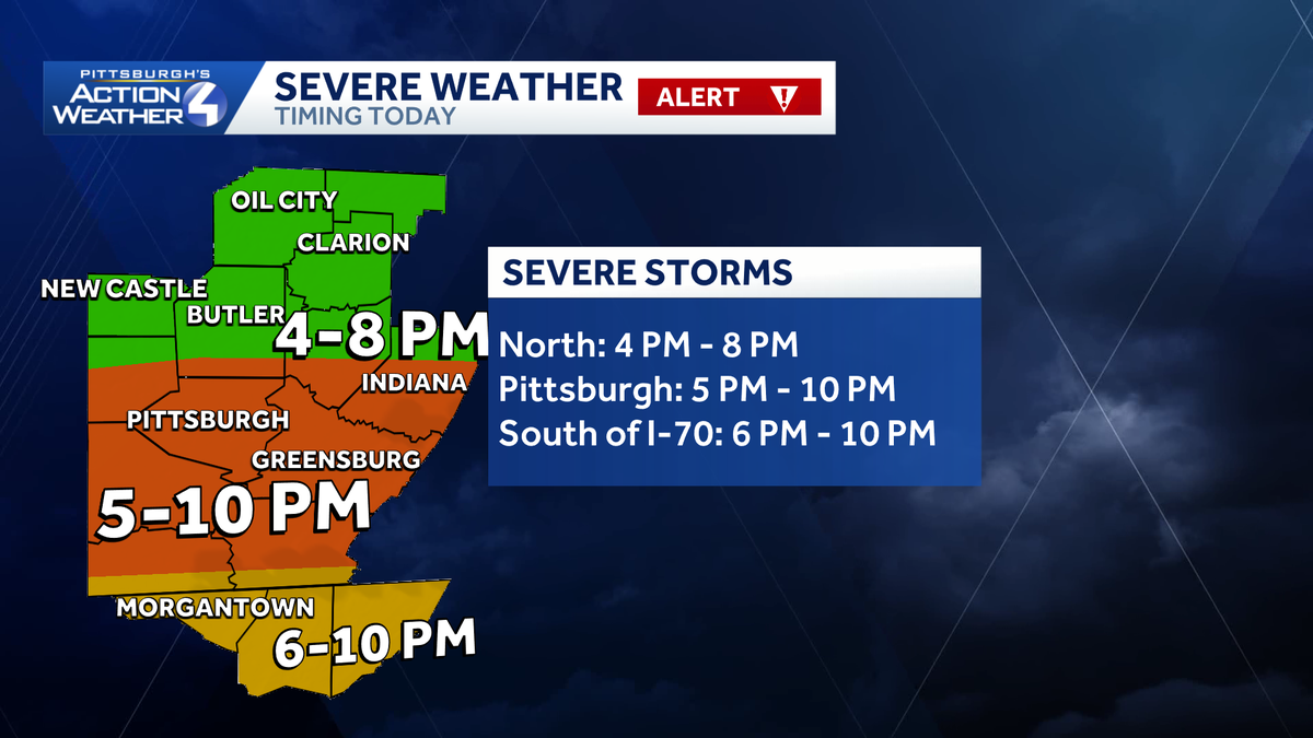
Timing the thunderstorms
Isolated showers and storms could pop as early as 3 p.m. to 4 p.m. north of I-80. Activity will drift south and should arrive for most around Pittsburgh between 5-6pm. Areas south of I-70 will likely see their window open after 6 p.m.

Hearst OwnedHearst
The window for thunderstorms is open between 4 p.m. and 10 p.m. for western PA.
The strong storm potential fizzles after sunset. Pockets of heavy rain will linger through 2 a.m. Our focus will shift to localized flooding concerns, especially south of I-70 and in the Laurel Highlands. Up to an inch of rain is expected in spots. Everyone is dry by the Monday morning commute.

Hearst OwnedHearst
The heavy rain and localized flooding risk will continue through 2 a.m. Areas south of Pittsburgh will experience repeated downpours.
More seasonal for the week ahead
More seasonal air blows in behind today’s front. Monday will be the coolest day of the upcoming work week with highs only in the mid to upper 40s. High temperatures will moderate back into the 50s Tuesday and Wednesday. Milder temperatures and more rain arrive Thursday. This next front could also spark isolated thunderstorms.

Hearst OwnedHearst
The next day to watch is Thursday for area-wide rain and isolated storms.
TODAY – Severe Weather Alert Day: Breezy and much warmer. Scattered severe thunderstorms after 4 p.m. High: 77°.
TONIGHT – Severe Weather Alert Day: Thunderstorm fizzle after 10 p.m. Heavy rain continues until 2 a.m. Areas of fog. Low: 38°.
MONDAY: Breezy and much cooler with clearing skies. High: 47°, low: 29°.
TUESDAY: Seasonal with sunshine. High: 51°, low: 36°.
WEDNESDAY: Partly cloudy and milder. High: 58°, low: 42°.