
MIKE, LET’S START WITH YOU. THOSE STORMS JUST KEEP POPPING UP RIGHT AFTER WAVE MOVING THROUGH THE AREA, AND WE WILL HAVE MORE AS WE GO LATER INTO TONIGHT. WE DO HAVE A SEVERE THUNDERSTORM WATCH, WHICH IS IN EFFECT UNTIL 10 P.M. WE HAVE SEEN NUMEROUS STRONG TO SEVERE THUNDERSTORMS THAT HAVE BEEN POPPING UP ACROSS THE REGION. RIGHT NOW WE HAVE ONE WAVE THAT’S MOVING JUST THROUGH PITTSBURGH, MOVING DOWN TOWARDS THE WASHINGTON AREA. A SECOND WAVE WHICH IS UP TOWARDS THE NEWCASTLE AREA, CLARION AND DUBOIS. AS WE GET A LITTLE BIT CLOSER HERE, YOU’LL SEE WHERE WE ARE HAVING THE HEAVIER RAIN IN SOME AREAS AND ALSO SOME HAIL THAT IS COMING DOWN. YOU CAN SEE THE UP TOWARDS THE OIL CITY. WE HAVE SOME HEAVY RAIN THERE, BUT LOOK AT ALL THESE LIGHTNING STRIKES THAT ARE HEADING TOWARDS NEW STANTON YOUNGWOOD ALSO GREENSBURG, WE ARE GOING TO BE SEEING SOME HEAVY RAIN DOWN TOWARDS THE MONESSEN AREA AS WELL. THAT’S ALL MOVING TO THE EAST VERY QUICKLY AT ABOUT 50MPH AND UP TO THE NORTH YOU CAN SEE THE STRONG CELL THAT’S MOVING THROUGH ROCKLAND RIGHT NOW. THAT IS TOWARDS CRANBURY AND MOVING TOWARDS THE CLARION AREA AS WELL. AND ALSO WE HAVE MORE OUT TO THE WEST THAT WILL BE MOVING IN. SO IF YOU’RE DOWN SOUTH OF PITTSBURGH, YOU CERTAINLY COULD BE SEEING SOME MORE STORMS THAT WILL BE MOVING IN YOUR DIRECTION. AND WITH MORE ON WHAT’S HAPPENING OUT THERE THIS AFTERNOON AND AS WE GO FORWARD, HERE’S METEOROLOGIST JEFF VERSZYLA. ALL RIGHT. THANKS VERY MUCH, MIKE. AS WE HEAD TOWARD, SAY, THE MIDDLE PART OF THIS EVENING, IT LOOKS LIKE THE SEVERE WEATHER THREAT IS GOING TO START TO FIZZLE. BY THE MID TO LATTER PART OF THE EVENING WILL SORT OF EVOLVE INTO MORE POCKETS OF HEAVY RAIN. AS WE APPROACH THE 11:00 HOUR TONIGHT, YOU CAN SEE REPRESENTED THERE AND SORT OF THE ORANGE AND RED COLORING. THOSE WILL BE SOME OF THOSE POCKETS OF HEAVIER RAIN THAT MAY BE MOVING THROUGH, APPROACHING IN JUST AFTER MIDNIGHT TONIGHT. LOOKS LIKE THE WHOLE WAVE OF RAIN SHOULD BE TAPERING OFF BY 230, 3:00 IN THE MORNING. SO THE GOOD NEWS IS AHEAD OF TOMORROW MORNING’S COMMUTE. THE RAIN WILL BE GONE. COULD SEE SOME LINGERING CLOUDS FIRST THING TOMORROW MORNING. BUT EVEN AS WE GET DEEPER INTO THE DAY, SOME OF THOSE CLOUDS WILL START TO BREAK UP AND GIVE WAY TO SUNSHINE.
Severe Thunderstorm Watch in place in Western Pa.
Damaging winds, heavy rain, large hail and brief spin-ups are potential storm threats.

Updated: 6:49 PM EDT Mar 22, 2026
A Severe Thunderstorm Watch remains in place for multiple counties in Western Pennsylvania. Severe Thunderstorm WarningA Severe Thunderstorm Warning has also been issued for parts of Western Pennsylvania Sunday night. The warning is in effect for the following counties: Allegheny, Butler, Beaver, (until 7:30 p.m.) and Westmoreland (until 7:15 p.m.). Locations impacted include: McCandless Township, Cranberry, Moon Township, Franklin Park, East Liverpool, Aliquippa, Monaca, Wellsville, Hampton Township, Economy, Ambridge, Wexford, New Brighton, Toronto, Beaver, Calcutta, Baden, Sewickley and Zelienople.Additional locations impacted: Greensburg, Jeannette, Latrobe, Mount Pleasant, Irwin, McChesneytown-Loyalhanna, Manor, Youngwood, Derry, Lawson Heights, New Stanton, Ligonier, Calumet-Norvelt, North Irwin, Penn, Madison, Arona, Youngstown, Hunker and Adamsburg.More: Read the weather alert for your countyInteractive radar: Track snow in your areaLearn how to enable automatic weather alerts on the WTAE mobile appSevere Thunderstorm Watch A Severe Thunderstorm Watch remains in place for multiple counties until 10 p.m. The watch has been issued for the following: Butler, Beaver, Indiana, Allegheny, Armstrong, Washington, Westmoreland, Fayette, and Greene counties. A passing cold front is the focus of today’s thunderstorm development. The most active hours for heavy rain and thunderstorms will be between 5 p.m. and 10 p.m. The main severe threats are damaging winds, brief downpours, and isolated large hail, up to the size of golf balls.More seasonal next weekMore seasonal air blows in behind today’s cool front. Monday will be the coolest day of the upcoming work week with highs only in the mid to upper 40s. High temperatures will moderate back into the 50s Tuesday and Wednesday. Milder temperatures and more rain arrive Thursday. This next front could also spark isolated thunderstorms.TODAY – Severe Weather Alert Day: Breezy and much warmer. Scattered severe thunderstorms after 4 p.m. High: 77°.TONIGHT – Severe Weather Alert Day: Thunderstorm fizzle after 10 p.m. Heavy rain continues until 2 a.m. Areas of fog. Low: 38°.MONDAY: Breezy and much cooler with clearing skies. High: 47°, low: 29°.TUESDAY: Seasonal with sunshine. High: 51°, low: 36°.WEDNESDAY: Partly cloudy and milder. High: 58°, low: 42°.
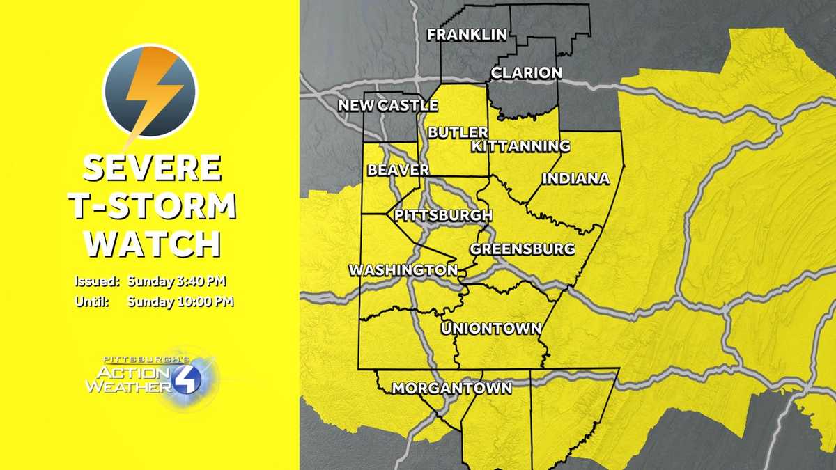
A Severe Thunderstorm Watch remains in place for multiple counties in Western Pennsylvania.
Severe Thunderstorm Warning
A Severe Thunderstorm Warning has also been issued for parts of Western Pennsylvania Sunday night.
The warning is in effect for the following counties: Allegheny, Butler, Beaver, (until 7:30 p.m.) and Westmoreland (until 7:15 p.m.).
Locations impacted include: McCandless Township, Cranberry, Moon Township, Franklin Park, East Liverpool, Aliquippa, Monaca, Wellsville, Hampton Township, Economy, Ambridge, Wexford, New Brighton, Toronto, Beaver, Calcutta, Baden, Sewickley and Zelienople.
Additional locations impacted: Greensburg, Jeannette, Latrobe, Mount Pleasant, Irwin, McChesneytown-Loyalhanna, Manor, Youngwood, Derry, Lawson Heights, New Stanton, Ligonier, Calumet-Norvelt, North Irwin, Penn, Madison, Arona, Youngstown, Hunker and Adamsburg.
Severe Thunderstorm Watch
A Severe Thunderstorm Watch remains in place for multiple counties until 10 p.m.
The watch has been issued for the following: Butler, Beaver, Indiana, Allegheny, Armstrong, Washington, Westmoreland, Fayette, and Greene counties.

A passing cold front is the focus of today’s thunderstorm development.
The most active hours for heavy rain and thunderstorms will be between 5 p.m. and 10 p.m. The main severe threats are damaging winds, brief downpours, and isolated large hail, up to the size of golf balls.
More seasonal next week
More seasonal air blows in behind today’s cool front. Monday will be the coolest day of the upcoming work week with highs only in the mid to upper 40s. High temperatures will moderate back into the 50s Tuesday and Wednesday. Milder temperatures and more rain arrive Thursday. This next front could also spark isolated thunderstorms.

Hearst OwnedHearst
More rain and storms are possible on Thursday.
TODAY – Severe Weather Alert Day: Breezy and much warmer. Scattered severe thunderstorms after 4 p.m. High: 77°.
TONIGHT – Severe Weather Alert Day: Thunderstorm fizzle after 10 p.m. Heavy rain continues until 2 a.m. Areas of fog. Low: 38°.
MONDAY: Breezy and much cooler with clearing skies. High: 47°, low: 29°.
TUESDAY: Seasonal with sunshine. High: 51°, low: 36°.
WEDNESDAY: Partly cloudy and milder. High: 58°, low: 42°.