
The stormy weather has ended. You will still have to navigate puddles and patchy fog during the morning commute. Temperatures will be much cooler after yesterday’s record high. More rain is on the way by Thursday.Much cooler todayThe rain has exited, but still be aware of puddles and patchy dense fog during your morning drive. Morning clouds will give way to some sunshine by the afternoon. Stray sprinkles and flurries to the north are possible. Much, much cooler air is now blowing in. Temperatures will continue to tumble into the 30s through 9 a.m. Readings will only recover into low and mid 40 by late-day. That is some 35 to 40 degrees cooler than yesterday’s record high in Pittsburgh.More seasonal through mid-weekHigh temperatures will moderate through the middle of the week. A definite chill to kick off your Thursday with lows in the 20s. Readings will spike around 50° with plenty of sunshine by the afternoon. The 60s return Wednesday.Thursday: Western PA’s next rain chanceThursday will begin as another nice spring day with highs in the mid 60s. We are watching another cold front that will sweep through western Pennsylvania. Rain will arrive late-day and could impact the evening commute. The wettest timeframe looks to be overnight. Periods of rain with an isolated thunder chance will stretch into Friday morning. Temperatures will be knocked back, again, into the 40s to wrap up the work and school week.At this point, the weekend will be dry and seasonably cool. Highs still be in the 40s on Saturday before skipping to mid 50s on Sunday. A warming trend will take shape heading into April in the long-term forecast.TODAY: Much cooler; temperatures fall through late morning. Low 40s this afternoon. Slow clearing with isolated sprinkles and flurries north.TONIGHT: Colder and mainly clear. Low: 25°.TUESDAY: Plenty of sunshine and seasonal. High: 50°, low: 34°.WEDNESDAY: Comfortable with skies becoming partly cloudy. High: 60°, low: 44°.THURSDAY: Warmer with late-day rain, possible thunder. High: 66°, low: 40°.
PITTSBURGH —
The stormy weather has ended. You will still have to navigate puddles and patchy fog during the morning commute. Temperatures will be much cooler after yesterday’s record high. More rain is on the way by Thursday.
Much cooler today
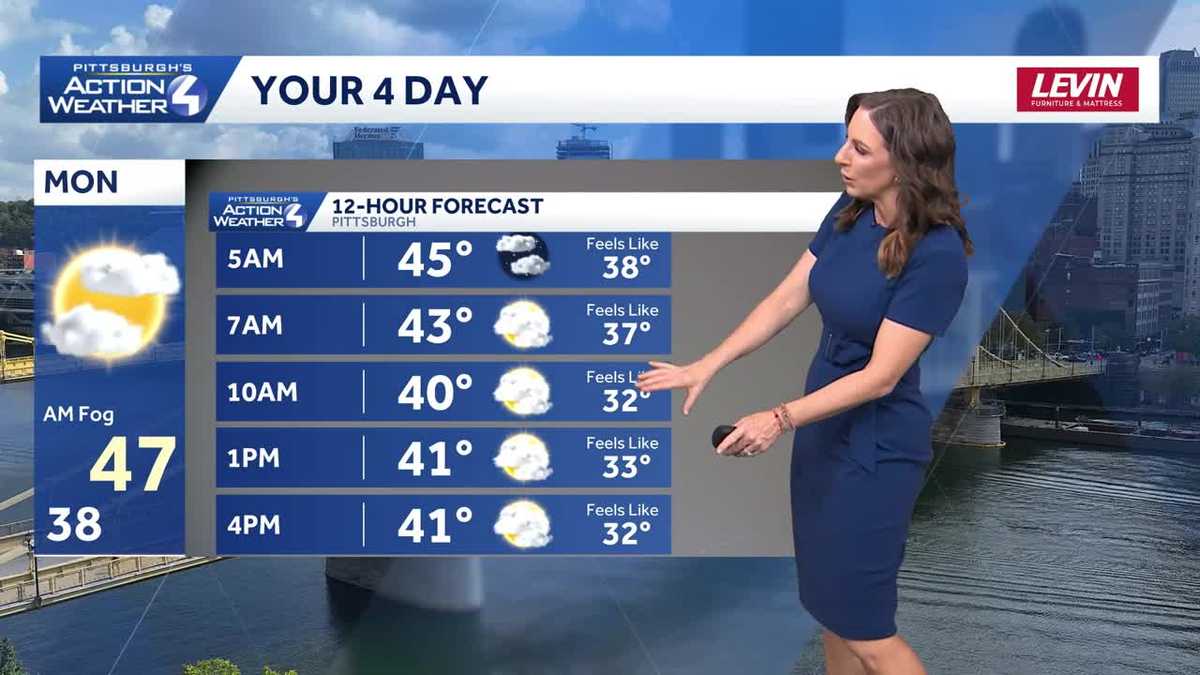
The rain has exited, but still be aware of puddles and patchy dense fog during your morning drive. Morning clouds will give way to some sunshine by the afternoon. Stray sprinkles and flurries to the north are possible. Much, much cooler air is now blowing in.

Hearst OwnedHearst
Temperatures bottom out around 9 a.m.
Temperatures will continue to tumble into the 30s through 9 a.m. Readings will only recover into low and mid 40 by late-day. That is some 35 to 40 degrees cooler than yesterday’s record high in Pittsburgh.

Hearst OwnedHearst
There won’t be much of a “warm” up today. Afternoon temperatures will only reach the low to mid 40s.
More seasonal through mid-week
High temperatures will moderate through the middle of the week. A definite chill to kick off your Thursday with lows in the 20s. Readings will spike around 50° with plenty of sunshine by the afternoon. The 60s return Wednesday.

Hearst OwnedHearst
A quiet and dry stretch through mid-week for western PA. Temperatures will moderate too.
Thursday: Western PA’s next rain chance
Thursday will begin as another nice spring day with highs in the mid 60s. We are watching another cold front that will sweep through western Pennsylvania. Rain will arrive late-day and could impact the evening commute. The wettest timeframe looks to be overnight. Periods of rain with an isolated thunder chance will stretch into Friday morning. Temperatures will be knocked back, again, into the 40s to wrap up the work and school week.

Hearst OwnedHearst
Rain returns late Thursday and will stretch into Friday morning.
At this point, the weekend will be dry and seasonably cool. Highs still be in the 40s on Saturday before skipping to mid 50s on Sunday. A warming trend will take shape heading into April in the long-term forecast.

Hearst OwnedHearst
Thursday’s highs in the mid 60s is more of a blip. Temperatures are cooling off again into the start of the weekend.
TODAY: Much cooler; temperatures fall through late morning. Low 40s this afternoon. Slow clearing with isolated sprinkles and flurries north.
TONIGHT: Colder and mainly clear. Low: 25°.
TUESDAY: Plenty of sunshine and seasonal. High: 50°, low: 34°.
WEDNESDAY: Comfortable with skies becoming partly cloudy. High: 60°, low: 44°.
THURSDAY: Warmer with late-day rain, possible thunder. High: 66°, low: 40°.