

SCRANTON — A safety-focused action plan aims to halve the number of fatal and severe crashes in Lackawanna County by 2045.
It’s a longer-range goal that will require collaboration among the county, local municipalities, transit providers and other potential partners and stakeholders working to implement the “Safe Streets Lackawanna” plan that Commissioners Thom Welby, Bill Gaughan and Chris Chermak adopted last week.
The county plan is separate and distinct from the “Downtown Scranton Connectivity Plan,” often referred to as the city’s walkability study, which proffered recommendations to improve pedestrian safety and traffic flow downtown. Scranton has already begun implementing elements of that broader plan.
Among other features, the Safe Streets Lackawanna plan identifies a “high injury network” of roadways where the majority of fatal and serious-injury crashes occurred in the county from 2019-23. There were 399 high-injury crashes countywide during that period, including 87 fatal crashes.
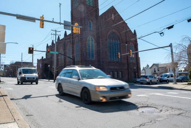 The intersection of Mulberry St. and Jefferson Ave. in Scranton on Tuesday, March 24, 2026. (REBECCA PARTICKA/STAFF PHOTOGRAPHER)
Of roughly 2,040 miles of roadway within the county’s borders, the high-injury network accounts for just about 122 miles, or 6% of the total. But during that recent period of years, the 6% of roadway miles comprising the network “was responsible for more than half (53%) of high injury crashes” in the county, the plan notes.
The majority of roadway miles making up Lackawanna’s high-injury network — approximately 89 of the 122 total miles — are located in a geographic region that includes Scranton (54.51 miles); Dunmore (12.99 miles); Moosic (12.81 miles); Taylor (6.65 miles); and Old Forge (2.2 miles).
That region captured 46% of the 399 high-injury crashes, a high percentage the plan attributes to denser development in and around Scranton and “more vehicles on the roadways compared to other regions.”
Other planning regions broken out in the plan generally include the Midvalley and Upvalley areas, which had 23% of the high-injury crashes; the Abingtons, which had 16%; and North Pocono, which had 15%.
Specific streets and roads comprising the high-injury network, broken out by municipality, are listed in the plan.
Priorities
The plan also identifies a number of priority corridors — Moosic Street/Route 307; the Scranton-Carbondale Highway/Business Route 6; Pittston Avenue/Route 11; Mulberry Street/Routes 11 and 307; the Scranton Pocono Highway/Routes 307 and 435; State Street/Routes 6 and 11; and Brooklyn Street/8th Avenue/Business Route 6 — and potential projects to improve safety there.
For example, an overview of Mulberry Street running through downtown Scranton notes the wide roadway “leads to excessive speeds and long crossing distances for pedestrians at intersections.” Of eight high-injury crashes recorded there between 2019-23, four involved a pedestrian being struck by a vehicle at an intersection.
“Many intersections have dedicated right turn lanes that could be removed to provide curb extensions to reduce crossing distances and increase visibility,” the Mulberry Street section of the plan notes.
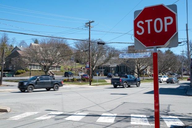 The intersection of State St. and Depot St. in Clarks Summit on Tuesday, March 24, 2026. (REBECCA PARTICKA/STAFF PHOTOGRAPHER)
All five of the high-injury crashes on the State Street corridor in Clarks Summit involved aggressive driving, per the plan, which lists the addition of rumble strips, flashing yellow turning arrows and intersection warning signage among other examples of potential countermeasures that could calm traffic and bolster visibility in the interest of safety.
An appendix to the plan lists dozens of potential safety improvements and related cost estimates, but the plan itself also lists a number of safety strategies that don’t involve infrastructure projects. They include, among numerous other examples, targeted police enforcement near school zones and along the high-injury network and expanded education about the dangers of aggressive driving.
Implementation
Supported by the U.S. Department of Transportation’s Safe Streets for All (SS4A) program, the extensive county plan is the product of a couple of years of effort by county officials, a local steering committee and Bowman Consulting Group, the firm commissioners hired for the safe-streets initiative in June 2024.
A $200,000 federal grant the county secured for the project, which included extensive public engagement, covered the vast majority of the county’s $224,330 contract with Bowman. And now that it’s done, the plan itself should help municipal applicants bolster their case for grant funding for potential safety improvement projects it identifies, officials said.
Addressing commissioners last week, county Planning Director Mary Liz Donato described the document as a “framework for the local municipalities to apply for any type of safety funding through transportation agencies, whether federal or state.” The county will ask municipalities to sign onto the plan, she said, noting “it gives them an extra tool for when they apply for grant funding.”
Municipal buy-in will be key in implementing the many elements of the plan the county can’t advance or implement unilaterally.
Reached Tuesday, Welby said all three commissioners — he, Gaughan and Chermak — support “working on this immediately with all of the municipalities,” targeting “trouble spots” identified in the plan.
“None of it is easy, but some of it can be easily attained,” Welby said.
Gaughan and Chermak expressed similar sentiments.
“This report gives us a roadmap now over the next several years to attack the problem, to go into these municipalities and boroughs and townships and work with the local officials to make the roadways safer,” Gaughan said. “And there’s a lot of different things that are identified in the report that we will start immediately.”
Chermak said the goal is to prioritize safety.
“Getting this all put in place was step one, so now we’ll work on the rest of it,” he said. “It’s a good initiative and it’s important, obviously.”
The plan is available online at lackawannacounty.org.