
Clouds & some sun, milder today; rain returns late Thursday in south-central Pennsylvania
Highs will reach the mid-50s this afternoon, then soar to 70 degrees Thursday.
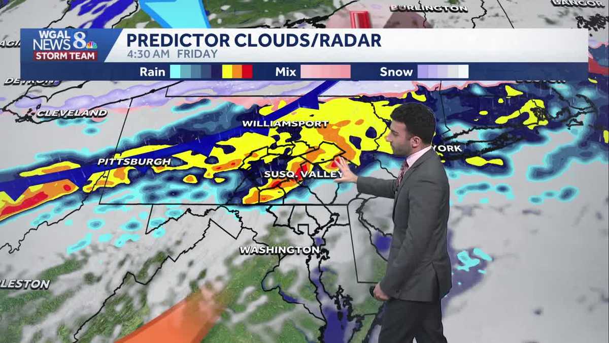
BLOSSOMS BEFORE THEY UNFORTUNATELY START TO FADE. NOW. THE WGAL NEWS EIGHT STORM TEAM FORECAST WITH METEOROLOGIST RYAN MARCIANTE A MOSTLY CLOUDY DAY SO FAR, BUT YOU CAN SEE THE WINDS ARE BEGINNING TO PICK UP. YOU CAN SEE THE FLAG OVER THE YORK SKY CAM RIGHT NOW, JUST STARTING TO STARTING TO SPREAD OUT NOW AS THE WINDS START TO INCREASE. AS WE GO THROUGH THE REST OF THE AFTERNOON AND GETTING INTO THE EVENING, TEMPERATURES HAVE BEEN RIGHT INTO THE 40S SO FAR, SOME OTHER AREAS HITTING RIGHT AROUND 50 DEGREES. BUT AS WE GET INTO THE REST OF THIS AFTERNOON, WE’LL SEE SOME MORE CLOUDS. WE COULD SEE A COUPLE BREAKS OF SOME SUNSHINE, BUT I’M EXPECTING TO SEE SOME MILDER CONDITIONS AS THE MAIN THEME FOR THE DAY. AND AS WE GET INTO LATE THURSDAY, LOOKING AT THOSE RAIN CHANCES RETURNING, IT WILL BE A COOL START, BUT A SEASONABLE END FOR THE WEEKEND AS WE AS WE LOOK AHEAD INTO THIS WEEKEND. SO FOR THE REST OF THIS AFTERNOON, A COUPLE OF BREAKS OF SOME SUNSHINE MILDER INTO THE MID 50S WILL GO. AND THEN FOR THIS EVENING DOWN TO THE LOWER 50S, COULD SEE A STRAY SHOWER LATER ON THIS EVENING. BUT IT’S, IT’S A STRAY CHANCE, BUT IT’S GOING TO ACCOUNT FOR THAT, THAT THAT STRAIGHT CHANCE FOR LATER ON. BUT WE’LL HAVE THAT LIGHT BREEZE AND THEN THAT BREEZE WILL START TO PICK UP AS WE GET INTO LATER ON TONIGHT IT WILL BE MOSTLY CLOUDY DOWN TO THE LOWER 40S, WILL GO FOR THE OVERNIGHT LOW TEMPERATURES. YOU CAN SEE 40S AS WE AS WE SPEAK NOW ARE 48 IN LANCASTER, 46 IN YORK, 46 IN CARLISLE AT THIS TIME. AND WINDS ARE STARTING TO PICK UP OUT OF THE SOUTH. I’D SAY GENERALLY BETWEEN 5 AND 10MPH, BUT YOU CAN SEE A COUPLE 12 MILE AN HOUR OBSERVATIONS FROM HARRISBURG AND CARLISLE AT THIS TIME. SO WE’LL SEE A LITTLE BIT OF A LIGHT BREEZE NOW. STORM TEAM, LIVE RADAR NETWORK. I’VE BEEN WATCHING THIS. NOW WHAT’S HAPPENING IS THAT I JUST ACTUALLY BEFORE WE WENT ON THE AIR, I WENT OUTSIDE OUR STATION AND LOOKED UP AND THERE’S NO RAIN FALLING. WHAT I DEFINITELY THINK THIS IS, IS WHAT WE CALL VIRGA IS. SO IT’S BASICALLY PRECIPITATION THAT FALLS FROM THE CLOUD, BUT THEN IT’S A DRY LATER, A DRY LAYER RIGHT BELOW THAT CLOUD AND DOESN’T END UP MAKING IT TO THE GROUND. SO THAT’S MOST LIKELY WHAT WE’RE SEEING HERE ON STORM TEAM LIVE RADAR NETWORK, AS WE HAVE A BIT OF A DISTURBANCE THAT STARTS TO MOVE BY. BUT YOU SEE HIGH PRESSURE DOES WIN OUT DOES IT’S IT’S HELPING TO FEED INTO THE MILDER CONDITIONS OR THE MILDER AIR FROM THE SOUTH. AND THEN AS WE HAVE THIS COLD FRONT THAT’S SLOWLY APPROACHES FROM THE NORTH. GOT A FEW DISTURBANCES IN THE MIX AS WE GET INTO OUR THURSDAY. THAT’S GOING TO HELP GIVE US A CHANCE OF A FEW AFTERNOON SHOWERS. YOU CAN SEE YOU CAN SEE HERE AS WHAT PREDICTORS ARE HIGHLIGHTING HERE. WE’LL STILL HAVE THAT MILDER AIR THOUGH, FOR THURSDAY WILL BE GETTING INTO THE 70S. SO CERTAINLY IT WILL FEEL NICE. BUT THEN AS THIS COLD FRONT STARTS TO PUSH THROUGH AS WE GET INTO LATE THURSDAY, EARLY FRIDAY, THAT’S GOING TO GIVE US A DECENT BIT OF SOME RAIN WHERE YOU CAN SEE SOME OF THE YELLOWS, THE ORANGES HERE, MAYBE A COUPLE OF REDS IN THERE, SO MAYBE SOME SOME HEAVY RAIN ASSOCIATED IN SOME LOCALIZED AREAS. BUT THAT WILL START TO PUSH THROUGH. BUT PREDICTOR IS HIGHLIGHTING THAT THERE COULD BE SOME SNOW, ALTHOUGH FROM MY FROM WHAT I’VE BEEN SEEING, THE UPPER LEVEL TEMPERATURES, I DON’T THINK I DON’T THINK THE TEMPERATURES ARE GOING TO BE FAVORABLE ENOUGH TO EVEN ALLOW SNOW TO EVEN HAPPEN. SO I REALLY THINK THERE’S GOING TO BE SOME RESIDUAL SHOWERS FOR LATE FRIDAY EVENING. NOW, IN TERMS OF THE IN TERMS OF RAINFALL, I’D SAY ABOUT A QUARTER TO HALF INCH OF SOME RAIN POSSIBLE ISOLATED ONE ONE INCH OF SOME RAIN AS WE GET INTO OUR LATE FRIDAY EVENING. BUT THEN HERE COMES THE WEEKEND. BREEZY AND COOLER. A LITTLE BIT MORE PLEASANT AS BEGINNING TO S
Clouds & some sun, milder today; rain returns late Thursday in south-central Pennsylvania
Highs will reach the mid-50s this afternoon, then soar to 70 degrees Thursday.

Updated: 12:39 PM EDT Mar 25, 2026
More cloud cover and milder temperatures are on tap for the afternoon. Highs will reach the mid-50s, and a spotty afternoon or evening shower is possible.Tonight, lows will fall to the mid-40s under mostly cloudy skies.Thursday will be warmer, with highs near 70 degrees, and a few showers during the day. As a cold front approaches, the highest chance of rain comes Thursday night into Friday morning. A few tenths of an inch to 0.50″ of rain is expected.After rain ends Friday morning, there’s a chance of lingering showers in the afternoon and evening, especially south of the PA Turnpike, as the cold front slowly moves southeast. Highs will hit the 50s in the morning, then fall to the 40s by afternoon, thanks to a stiff breeze from the northwest.A dry weekend is in store for the Susquehanna Valley. Look for partly sunny and breezy conditions Saturday. Highs will be cool, in the upper 40s. Temperatures will climb to the mid-50 Sunday under mostly sunny skies.Highs will continue to climb to the 60s early next week. A few showers are possible Monday and Tuesday, then again late Thursday into Friday.Have a good Wednesday!~ Ryan
More cloud cover and milder temperatures are on tap for the afternoon. Highs will reach the mid-50s, and a spotty afternoon or evening shower is possible.
Tonight, lows will fall to the mid-40s under mostly cloudy skies.
Thursday will be warmer, with highs near 70 degrees, and a few showers during the day. As a cold front approaches, the highest chance of rain comes Thursday night into Friday morning. A few tenths of an inch to 0.50″ of rain is expected.
After rain ends Friday morning, there’s a chance of lingering showers in the afternoon and evening, especially south of the PA Turnpike, as the cold front slowly moves southeast. Highs will hit the 50s in the morning, then fall to the 40s by afternoon, thanks to a stiff breeze from the northwest.
A dry weekend is in store for the Susquehanna Valley. Look for partly sunny and breezy conditions Saturday. Highs will be cool, in the upper 40s. Temperatures will climb to the mid-50 Sunday under mostly sunny skies.
Highs will continue to climb to the 60s early next week. A few showers are possible Monday and Tuesday, then again late Thursday into Friday.
Have a good Wednesday!
~ Ryan