
IMPACT: Frost advisory overnight, sun & clouds tomorrow afternoon across south-central Pennsylvania
A Frost Advisory has been issued for tonight. The weekend remains dry along with the start of the last week of October before rain chances return. While highs are cooler than average, chillier air arrives for the upcoming week.
CONGRATS, IVAN! WELL, IT WAS A NICE DAY TO BE ON THE FOOTBALL FIELD OR EVEN JUST GET OUTSIDE. RYAN. ALTHOUGH IT DEFINITELY FELT LIKE OCTOBER OUT THERE. DEFINITELY SEASONABLY COOL. THAT’S HOW WE LIKE TO. THAT’S HOW WE LIKE TO SAY FOR THIS TIME OF YEAR FOR OCTOBER. BUT IT’S ALSO GOING TO BE IT’S ALSO FOR THIS TIME OF THE YEAR, FROST FOR PORTIONS OF THE AREA, ESPECIALLY FOR YORK, DAUPHIN, LEBANON AND LANCASTER COUNTIES, WHERE WE DO HAVE A FROST ADVISORY GOING INTO EFFECT FROM 2 A.M. TO 9 A.M. SUNDAY. BUT IT WILL BE A DRY AND PLEASANT DAY OVERALL. BUT THEN AS WE GET INTO THE MIDDLE OF THE WORKWEEK, THAT’S WHEN THE CHANCES FOR RAIN BEGIN TO INCREASE, ESPECIALLY WEDNESDAY, AND ALSO FOR YOUR THURSDAY. SO THAT’S WHY WE HAVE THE IMPACT ICON FOR THE FROST ADVISORY WITH SOME POTENTIAL VALLEY FOG TEMPERATURES GETTING INTO THE LOWER 30S. 34 TO 40 DEGREE RANGE. SO THAT’S USUALLY THE RANGE THAT WE LOOK FOR WHEN WE’RE GOING TO BE FORECASTING FOR FROST. AND SO THAT’S WHAT WE WILL BE EXPECTING FOR OVERNIGHT TONIGHT. GETTING INTO TOMORROW MORNING I LEFT THE IMPACT ICON THERE UP UNTIL ABOUT 9 A.M. SO THAT’S THAT’S WHAT I WANT TO EMPHASIZE. THE TIMING. AT 9 A.M. WE WILL HAVE A FROSTY START WITH SOME CALM WINDS OUT OF THE NORTH AND MOSTLY SUNNY TO FOR THE DAY, 44 TO 50 DEGREES AS WE GET INTO TOMORROW MORNING. THEN FOR THE AFTERNOON 58 TO 62 DEGREES WITH SOME CLOUDS AND SOME SUNSHINE. PLEASANT AND COOL. GOT A NORTH NORTHEASTERLY BREEZE RIGHT AROUND 5 TO 10MPH. GETTING INTO THE LOWER 60S MARK FOR THE AFTERNOON. BUT THIS IS WHAT I WANT TO SHOW YOU FOR TONIGHT’S FORECAST. LOWS. GETTING INTO THE UPPER 30S AND MID 30S FOR SOME AREAS, INCLUDING YORK AND LANCASTER, LEBANON INTO THE UPPER 30S. RANGE 38 DEGREES FOR HARRISBURG AS WELL, WHICH IS WHY WE HAVE THAT FROST ADVISORY IN EFFECT FOR THESE COUNTIES. YORK, DAUPHIN, LEBANON AND LANCASTER COUNTIES FROM 2 A.M. TO 9 A.M. ON SUNDAY. NOW, WHAT YOU SHOULD DO IN TERMS OF THE ACTION YOU SHOULD TAKE, IF YOU HAPPEN TO HAVE ANY ANY PLANTS THAT ARE SENSITIVE TO THE COLD, LIKE TAKE MOMS FOR AN EXAMPLE. IF YOU HAVE THEM SITTING OUTSIDE, YOU’RE GOING TO WANT TO BRING THOSE INSIDE FOR OVERNIGHT TONIGHT BECAUSE TEMPERATURES COULD BE GETTING DOWN INTO THAT THAT MID 30S RANGE AND COULD DAMAGE THOSE PLANTS. NOW YOU’RE PROBABLY WONDERING, WELL, WHAT ABOUT MY AREA, ESPECIALLY IF YOU’RE LIVING IN FRANKLIN COUNTY, ADAMS COUNTY, CUMBERLAND, MIFFLIN, JUNIATA AND PERRY COUNTIES, YOUR GROWING SEASON HAS OFFICIALLY ENDED, ACCORDING ESPECIALLY FOR FRANKLIN, CUMBERLAND AND ADAMS COUNTY, WHERE WE DID HAVE A PUBLIC INFORMATION STATEMENT RELEASED BY THE NATIONAL WEATHER SERVICE THAT THAT INFORMATION STATEMENT HAD LET US KNOW THAT FOR THESE THREE COUNTIES, WE NOW HAVE THE GROWING SEASON HAVING ALREADY ENDED. BUT SO YOU HAVE NOW JOINED THAT LIST FOR THE END OF THE GROWING SEASON. THAT’S WHY YOU DIDN’T GET A FROST ADVISORY EARLIER TODAY. TEMPERATURES REACH THE UPPER 50S FOR HARRISBURG INTERNATIONAL TODAY, 62. THAT’S THE USUAL AVERAGE OR THE USUAL HIGH FOR THIS TIME OF THE YEAR. EARLIER THIS MORNING, RIGHT AROUND 36 DEGREES IS WHAT WE HIT. BUT WE ARE A LITTLE BIT BELOW AVERAGE FOR THIS TIME OF YEAR. WE DO EXPECT 43 DEGREES FOR OUR TYPICAL LOW TEMPERATURES, WEATHER, HEALTH FOR THE AFTERNOON TOMORROW. POLLEN LEVELS WILL BE LOW, MOLD LEVELS ARE LOW, AIR QUALITY WILL BE GOOD. UV INDEX IS LOW WITH A 50 MINUTE BURN TIME. TEMPERATURES RIGHT NOW INTO THE 40S. YOU CAN SEE 43 DEGREES IN LEWISTOWN, 47 DEGREES IN CHAMBERSBURG, FAIRLY DRY OUT THERE. AND THAT’S WHAT’S REALLY ALLOWING FOR THESE TEMPERATURES TO START TO GO DOWN TOWARDS THAT MID 30S MARK TO ALLOW FOR SOME OF THAT FROST ACROSS THE AREA. CURRENT SUSTAINED WINDS, VERY CALM RIGHT NOW. CURRENT STORM TEAM, LIVE RADAR NETWORK CURRENT. LOOK AT WHAT WE’RE SEEING IN TERMS OF SATELLITE IMAGERY AS WELL. I OVERLAID THAT OVER TOP OF THE RADAR, NOT SEEING ANY PRECIPITATION, BUT I DO EXPECT TO SEE A LITTLE BIT OF SOME INCREASED CLOUD COVER AS WE GET INTO TOMORROW MORNING. SOME SLIGHT CLOUD COVER. BUT THEN ONCE WE GET INTO THE AFTERNOON, WE GET ANOTHER SLIGHT INCREASE OF OF A MIX OF SOME CLOUDS AND SUNSHINE. BUT WE DO HAVE SOME HIGH PRESSURE SITUATED TOWARDS OUR NORTH. THAT’S WHAT’S GOING TO HELP KEEP US CLEAR FOR OUR MONDAY. WE’RE ALSO LOOKING AT THIS, THAT THIS DISTURBANCE TOWARDS OUR SOUTHEAST, WHICH MAY GIVE US A CHANCE OF SOME SHOWERS FOR THE MIDDLE OF THE WORKWEEK. NOW WE ARE TRACKING HURRICANE MELISSA. IT IS NOW A CATEGORY THREE HURRICANE. THIS HURRICANE, BY THE WAY, HAS QUICKLY INTENSIFIED AND WILL CONTINUE TO INTENSIFY TO A CATEGORY FOUR AND THEN A CATEGORY FIVE HURRICANE, POTENTIALLY BY MONDAY EVENING. AND THEN GOING OUT TO SEA BY THE TIME WE GET INTO THE END OF THE WORKWEEK NEXT WEEK. SO THAT’S WHAT WE’LL BE TRACKING AS WE GET INTO THE NEXT SEVERAL DAYS. BUT LOCALLY, BACK HOME, LOOKING AT CLOUDS AND SOME SUNSHINE FOR TOMORROW INTO THE MID 50S AND LOWER 60S, YOU CAN SEE THOUGH WEDNESDAY AND THURSDAY WE DO HAVE A CHANCE OF SOME SHOWERS NOW FOR HALLOWEEN FESTIVITIES. WE ARE SEEING A SLIGHT CHANCE OF SOME SHOWERS, MAINLY FOR THE MORNING, BUT IN TERMS OF TRICK OR TREATING FESTIVITIES,
IMPACT: Frost advisory overnight, sun & clouds tomorrow afternoon across south-central Pennsylvania
A Frost Advisory has been issued for tonight. The weekend remains dry along with the start of the last week of October before rain chances return. While highs are cooler than average, chillier air arrives for the upcoming week.

Updated: 12:00 AM EDT Oct 26, 2025
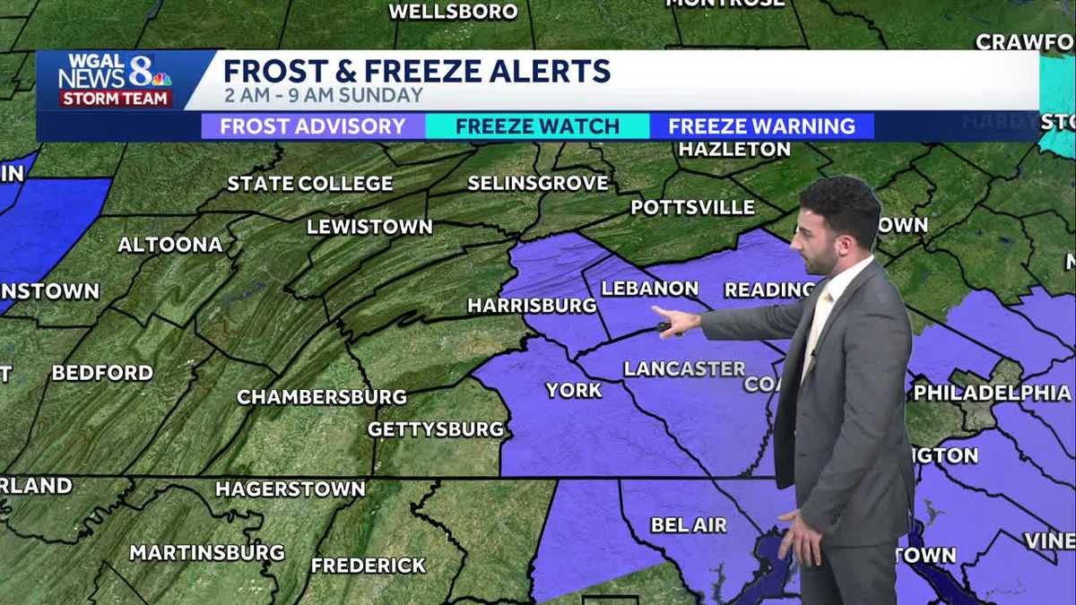
A Frost Advisory has been issued for Lancaster, Lebanon, Dauphin, and York counties from 2 AM through 9 AM Sunday. Tonight, cloud cover will decrease and the threat for frost is back in the picture overnight. Due to the Frost Advisory in effect for some of our counties (Lancaster, Lebanon, York, & Dauphin), the News 8 Storm Team has issued an Impact Night for the area. According to the National Weather Service, the growing season has now officially ended for Franklin, Adams, & Cumberland counties, alongside Mifflin, Juniata, & Perry counties. The growing season has not yet ended for Lancaster, Lebanon, York, & Dauphin counties, which is why only those four counties were issued the Frost Advisory. Temperatures are expected to bottom out in the low to mid 30s across the area.For the start of your Sunday, we’ll have mostly sunny skies. It’ll be a chilly & frosty start with the Frost Advisory issued up until 9 AM in the morning. Heading into the afternoon, clouds mix back in with sunshine with pleasant & cool conditions persisting. Highs are around 60°.The weather looks quiet and cooler than average to start next week as high pressure dominates our weather pattern Monday and Tuesday. Unfortunately, it does not last much longer.A wetter pattern begins to set up mid to late next week. Scattered showers are possible on Wednesday and Thursday. Some showers may linger into Friday for Halloween. Those who are planning to trick or treat around Halloween should have a backup plan for next Friday evening, as showers may still be around.The unsettled and cooler weather pattern continues into the start of November.Have a great rest of your night!~ Ryan
A Frost Advisory has been issued for Lancaster, Lebanon, Dauphin, and York counties from 2 AM through 9 AM Sunday.
Tonight, cloud cover will decrease and the threat for frost is back in the picture overnight. Due to the Frost Advisory in effect for some of our counties (Lancaster, Lebanon, York, & Dauphin), the News 8 Storm Team has issued an Impact Night for the area. According to the National Weather Service, the growing season has now officially ended for Franklin, Adams, & Cumberland counties, alongside Mifflin, Juniata, & Perry counties. The growing season has not yet ended for Lancaster, Lebanon, York, & Dauphin counties, which is why only those four counties were issued the Frost Advisory. Temperatures are expected to bottom out in the low to mid 30s across the area.
For the start of your Sunday, we’ll have mostly sunny skies. It’ll be a chilly & frosty start with the Frost Advisory issued up until 9 AM in the morning. Heading into the afternoon, clouds mix back in with sunshine with pleasant & cool conditions persisting. Highs are around 60°.
The weather looks quiet and cooler than average to start next week as high pressure dominates our weather pattern Monday and Tuesday. Unfortunately, it does not last much longer.
A wetter pattern begins to set up mid to late next week. Scattered showers are possible on Wednesday and Thursday. Some showers may linger into Friday for Halloween. Those who are planning to trick or treat around Halloween should have a backup plan for next Friday evening, as showers may still be around.
The unsettled and cooler weather pattern continues into the start of November.
Have a great rest of your night!
~ Ryan