
Strong storms to blow through the Pittsburgh area | Chance of hail, downpours
RIGHT HERE IN PNC PARK, CARLOS FLORES, PITTSBURGH’S ACTION NEWS FOUR. AND IT IS AN IMPACT DAY FOR US TODAY, BUT MAINLY FOR LATER TONIGHT. AND THIS IS GOING TO EXTEND INTO WEDNESDAY. WILL BE BREEZY AND WARM THROUGH THE DAY. CALMING DOWN A BIT. STILL A SMALL CHANCE FOR AN ISOLATED SHOWER THURSDAY, BUT VERY WARM AS WE SHOOT UP NEAR 80 DEGREES AND IT IS MILD AS YOU STEP OUT THIS MORNING. 65 WAKING UP IN PITTSBURGH. 64 MONROEVILLE AND GREENSBURG. THAT’S A CASE. ALSO BUTLER, CRANBERRY, EVEN WASHINGTON AND WAYNESBURG AND MORGANTOWN AT 64 DEGREES POPPING UP THERE ON OUR MAP THIS MORNING. MOSTLY CLOUDY SKIES. IT IS BREEZY ALREADY. THAT WILL BE THE TREND THROUGH THE DAY 25 TO 30 MILE PER HOUR WIND GUSTS. CAN’T RULE OUT A FEW PEEKS OF SUNSHINE, BUT WE ARE GOING TO CONTINUE TO SEE THESE CLOUDS LINGERING THAT SPRING-LIKE FEEL WILL STICK AROUND THROUGH THE WEEK. PIRATES HOME OPENER ON FRIDAY WE’LL HAVE A CHANCE FOR SOME SHOWERS, ESPECIALLY IN THE AFTERNOON AND EVENING, BUT IT’S NOT A WASHOUT OF A DAY, SO WE MAY BE DODGING SOME RAIN SHOWERS, BUT SHOULDN’T BE TOO BAD FOR THE GAME. I WANTED TO SHOW YOU THE STATIONARY FRONT BECAUSE IT’S JUST THAT IT IS STATIONARY NORTH OF US, AND THAT’S WHY YOU’RE GOING TO SEE A FEW SHOWERS. YOU CAN EVEN ROLL IT OUT UP ALONG I-80 THIS MORNING. SOME SPRINKLES, BUT THIS IS GOING TO START TO PUSH SOUTHWARD. AND THAT’S WHEN WE’RE GOING TO HAVE THE POTENTIAL FOR SEVERE WEATHER. HERE’S THE LATEST ON OUR FUTURECAST AS WE CONTINUE THROUGH THE DAY. A CHANCE FOR AN ISOLATED SHOWER THROUGH THE AFTERNOON. VERY ISOLATED. BUT OVERALL MOST OF US ARE STAYING DRY, JUST BREEZY AS WE GET AROUND NINE 10:00. THAT’S WHEN WE’LL START TO SEE THIS FRONT SAGGING SOUTHWARD. NOW IT COULD HAVE SOME DAMAGING WIND GUSTS POTENTIAL AGAIN FOR THOSE HEAVY DOWNPOURS. WHEN WE START TO SEE ALL THE COLORS HERE, REDS, ORANGES AND YELLOWS. THAT’S AN INDICATOR MORE HEAVY TO MODERATE RAIN. SO THIS COMING IN STILL AROUND 2 TO 3 A.M. IMPACTING A LOT OF THE AREA NORTH OF INTERSTATE 70. BUT UNFORTUNATELY, AS YOU HEAD OUT THE DOOR TOMORROW MORNING, WE’RE STILL GOING TO HAVE SOME RAIN POCKETS OF HEAVY RAINFALL. VISIBILITY IS GOING TO BE DROPPING THROUGH THAT MORNING COMMUTE. SO WE WILL KEEP THE IMPACT DAY NOT ONLY THROUGH THE MORNING BUT THROUGH THE ENTIRE DAY AS WE’RE STILL GOING TO HAVE RAIN SHOWERS AROUND LUNCHTIME. LITTLE BREAK, A LULL IN THE ACTIVITY AROUND TWO 3:00 WEDNESDAY, BUT THEN MORE SHOWERS AND NON-SEVERE STORMS DEVELOPING IN THE LATE AFTERNOON AND EVENING. WE’LL GET SOME RELIEF THOUGH, FROM THAT HEAVY RAIN AND THE STORM POTENTIAL AS WE GET INTO THURSDAY. NOW HERE’S WHAT WE’RE LOOKING AT WHERE YOU SEE THE YELLOW. THAT’S AN INDICATOR WHERE WE COULD HAVE SOME OF THOSE STRONG TO SEVERE STORMS WITH THE ONSET OF THAT FRONT MOVING IN HEAVY RAIN, DAMAGING WINDS, BIGGEST STORM THREAT FOR US. EVEN SOME HAIL. TORNADO THREAT IS LOW BUT CAN’T BE RULED OUT, ESPECIALLY UP ALONG I-80. AS THAT FRONT STARTS TO MOVE INTO THE REGION. NOW AS IT CONTINUES TO SLIDE THROUGH, IT WILL WEAKEN A LITTLE BIT, BUT OVERALL IT IS GOING TO BE ROUGH IN THE TIMING OF IT IS NOT PERFECT AS IT IS IN THE OVERNIGHT HOURS WHEN MOST OF US ARE SLEEPING. SO AS WE CONTINUE INTO THE WEEKEND, EASTER WEEKEND OF THAT ISOLATED SHOWER FOR THE FIRST DAY OF TROUT ON SATURDAY, BUT LOOKS GOOD.
Strong storms to blow through the Pittsburgh area | Chance of hail, downpours

Updated: 10:33 AM EDT Mar 31, 2026
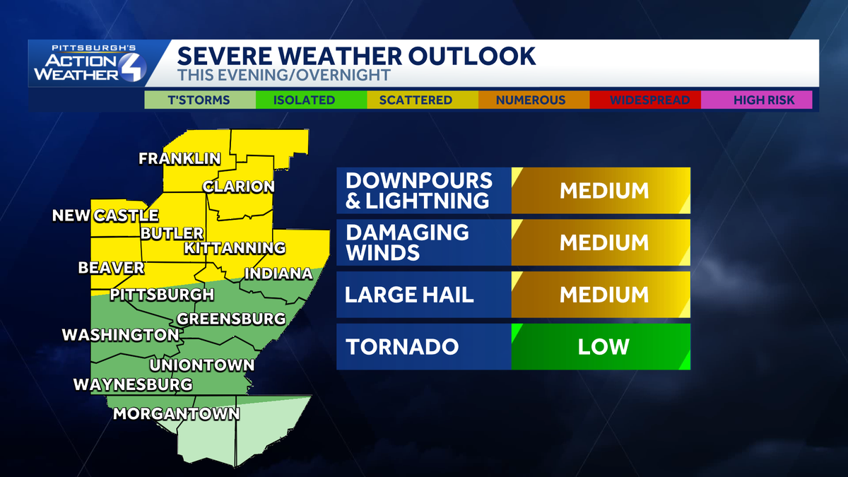
With warm weather kicking up in the Pittsburgh area, the area is looking at an uptick in daily rain and storm chances. Tuesday and Wednesday are Impact Days. Warming up to end MarchTemperatures are warming up and staying spring-like this week. Highs will bounce around the 60s, 70s, and 80s. A breeze with gusts of 25 to 30 mph will help with the warmup.Rain returns… Impact Days Today & WednesdayOur next decent shot for rain and storms starts tonight and into Wednesday. The best chance for rain and storms will be north of Pittsburgh, this evening. Activity will be area-wide, overnight through Wednesday.Wednesday is an Impact Day for the morning rain. We will see a brief break during the afternoon. Rain and storm chances return for the evening commute. The severe potential appears limited for western Pennsylvania. However, heavy rain and gusty winds are possible.Scattered rain chances linger for Thursday and Friday. It doesn’t look to be a rain out for the Pirates home opener, but Friday afternoon is trending a little soggy later in the day.An early look at Easter weekendUnfortunately, rain chances linger for Saturday and Sunday. At this early stage it looks like a few isolated showers Saturday. More sustained rain is scheduled for Easter morning. We will continue to monitor the timing as you make holiday plans.TODAY: Impact Day. Breezy and warmer, evening storms. High: 77°, low: 60°.WEDNESDAY – Impact Day. Early morning heavy rain and storms. Scattered late-day rain and storms. High: 70°, low: 56°.THURSDAY: Isolated showers and warmer. High: 80°, low: 62°.
With warm weather kicking up in the Pittsburgh area, the area is looking at an uptick in daily rain and storm chances.
Tuesday and Wednesday are Impact Days.
Warming up to end March
Temperatures are warming up and staying spring-like this week. Highs will bounce around the 60s, 70s, and 80s. A breeze with gusts of 25 to 30 mph will help with the warmup.

Rain returns… Impact Days Today & Wednesday
Our next decent shot for rain and storms starts tonight and into Wednesday. The best chance for rain and storms will be north of Pittsburgh, this evening. Activity will be area-wide, overnight through Wednesday.

Wednesday is an Impact Day for the morning rain. We will see a brief break during the afternoon. Rain and storm chances return for the evening commute. The severe potential appears limited for western Pennsylvania. However, heavy rain and gusty winds are possible.
Scattered rain chances linger for Thursday and Friday. It doesn’t look to be a rain out for the Pirates home opener, but Friday afternoon is trending a little soggy later in the day.
An early look at Easter weekend
Unfortunately, rain chances linger for Saturday and Sunday. At this early stage it looks like a few isolated showers Saturday. More sustained rain is scheduled for Easter morning. We will continue to monitor the timing as you make holiday plans.

TODAY: Impact Day. Breezy and warmer, evening storms. High: 77°, low: 60°.
WEDNESDAY – Impact Day. Early morning heavy rain and storms. Scattered late-day rain and storms. High: 70°, low: 56°.
THURSDAY: Isolated showers and warmer. High: 80°, low: 62°.