
Few showers & storms Saturday; rain likely Easter Sunday morning
Spotty showers and storms are possible Saturday. Rain is expected for Easter Sunday morning, then skies begin to clear later in the afternoon.
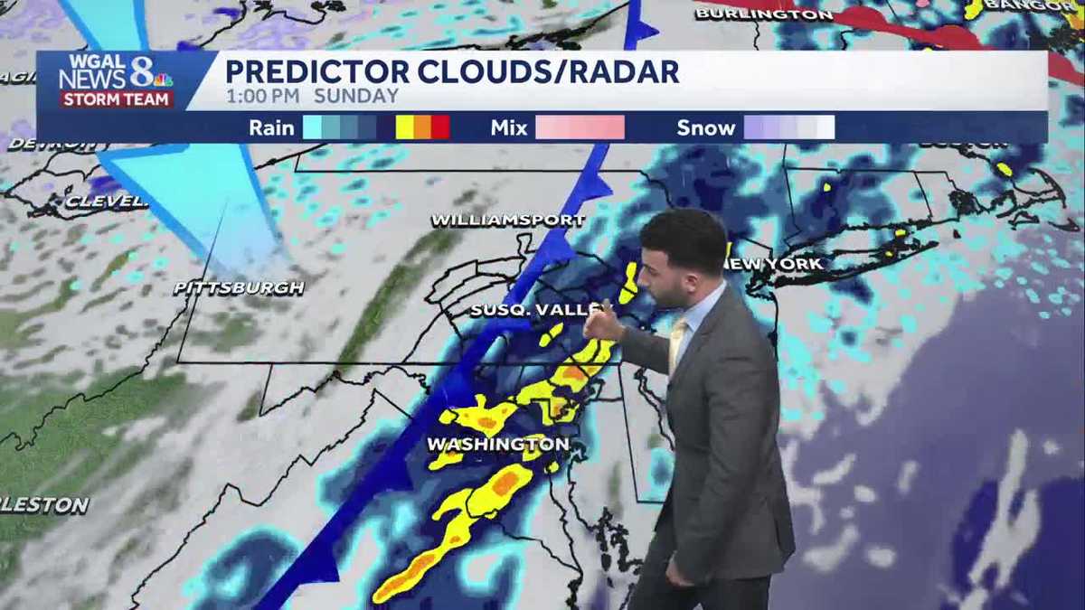
BE ABLE TO VOTE ON THE SENATE MEASURE DUE TO HOLIDAY SCHEDULING. NOW, THE WGAL NEWS EIGHT STORM TEAM FORECAST, WITH METEOROLOGIST RYAN MARCIANTE. BIT OF A DREARY. A BIT OF A WET START TO THE DAY. YOU CAN SEE YOUR TIME LAPSE FROM EARLIER THIS MORNING. A LITTLE BIT GRAY INJURY, BUT AS WE FAST FORWARD THROUGH THE AFTERNOON, HERE COMES HERE COMES THE BLUE SKIES. THAT’S RIGHT. WE’RE STARTING TO SEE SOME SUNSHINE AS WE GET INTO THE AFTERNOON TEMPERATURES. RIGHT NOW IT’S A WIDE RANGE OF TEMPERATURES, BY THE WAY, BUT RIGHT AROUND 69 DEGREES IN YORK AT THIS TIME WITH THE SOUTHERLY SEVEN MILE PER HOUR BREEZE. SO WE’LL SOON START TO START TO WARM UP. IN TERMS OF THE REST OF THIS EVENING AS WE GET INTO THE NEXT COUPLE OF HOURS HERE. SO WARMER SATURDAY THOUGH. HIGHS BACK TO THE 70S. AND AS WE HEAD INTO OUR EASTER SUNDAY, IT’S GOING TO BE WET, BUT IT’S NOT GOING TO BE A COMPLETE WASHOUT. JUST BE A RAINY START FOR EASTER SUNDAY, THEN START STARTING TO DRY UP AND BECOME COOLER AS WE GET INTO NEXT WEEK WHERE WE’RE GOING TO BE SEEING SOME TEMPERATURE SWINGS. AND WE’LL ALSO SEE A WARMER END TO NEXT WEEK, WHICH WE’LL CHAT ABOUT IN THE FULL TEN DAY FORECAST IN JUST A FEW MORE MINUTES. SO FOR THIS EVENING, EXPECT PARTLY CLOUDY CONDITIONS AND A FEW SHOWERS LATE IN THE IN THE EVENING, THEN A FEW SHOWERS EARLY FOR TONIGHT. STILL REMAINING. PARTLY CLOUDY THEN WILL BE PARTLY SUNNY FOR TOMORROW. WE ARE LOOKING AT THE CHANCE OF SEEING A FEW MORE SHOWERS AND THUNDERSTORMS LATER IN THE AFTERNOON AND EVENING. BUT IN TERMS OF EASTER EGG HUNTS, TEMPERATURES TOMORROW, GETTING UP INTO THE UPPER 70S, THERE’S THE TIMEFRAME, BY THE WAY, FOR THESE POTENTIAL AFTERNOON AND EVENING THUNDERSTORMS. 3 P.M. TO 8 P.M. FOR THE FIRST HALF OF THE WEEKEND. FOR SUNDAY, THE TIMING FOR THE MORNING RAIN SHOWERS IS GOING TO BE FROM 5 A.M. UNTIL RIGHT AROUND 3:00 IN THE AFTERNOON, AND THEN WE’LL START TO SEE SOME CLEARING AND BECOME BREEZY AS WE GET INTO THE REST OF OUR SUNDAY. SO POLLEN LEVELS, BY THE WAY, TREES AND GRASS THAT’S MODERATE FOR TOMORROW AFTERNOON. MOLD LEVELS ARE GOING TO REMAIN LOW. AIR QUALITY IS MODERATE, UV INDEX IS MODERATE AT ABOUT A 35 MINUTE BURN TIME FOR THE AFTERNOON. BUT LOOK AT THIS WIDE TEMPERATURE RANGE STRETCHING FROM 59 DEGREES IN HARRISBURG ALL THE WAY UP TO 77 DEGREES IN GETTYSBURG. AND THE REASON WHY IS BECAUSE WE HAVE THIS WARM FRONT. YOU CAN KIND OF SEE THE DELINEATION HERE OF BETWEEN THE COLDER AIR MASS THAT’S JUST OFF TOWARDS OUR NORTHEAST, AND THAT WARMER AIR THAT’S COMING IN FROM THE SOUTH, THAT’S NOW BEGINNING TO WORK ITS WAY INTO THE SUSQUEHANNA VALLEY. THAT’S WHY WE’RE SEEING THAT WIDE RANGE IN TEMPERATURES. BUT YOU CAN SEE JUST STARTING TO SEE PARTLY SUNNY CONDITIONS AFTER DEALING WITH SOME OVERCAST CONDITIONS, A BIT OF A COLD FRONT THAT’S DRAPED OVER TOWARDS OUR NORTHWEST. IT’S LEADING SOME THUNDERSHOWERS FIRE OFF TOWARDS NORTHWESTERN PA RIGHT NOW, BUT AS THAT WARM FRONT CONTINUES TO MOVE THROUGH AND THIS IS GOING TO USHER IN THIS MILDER AIR FROM THE SOUTH. BUT WITH ALL THESE FRONTAL BOUNDARIES NEARBY AND SOME MOISTURE THAT’S IN THE ATMOSPHERE, IT’S GOING TO ALLOW FOR MULTIPLE CHANCES FOR A FEW SHOWERS. AND THEN EVENTUALLY, ONCE WE GET INTO SATURDAY AFTERNOON, IN THE EVENING, A FEW THUNDERSTORMS. SO HERE’S SATURDAY MORNING. STILL SEEING A LITTLE BIT OF A SLIGHT SHOWER CHANCE, BUT IT WON’T BE UNTIL THE AFTERNOON. YOU SEE SOME OF THESE LITTLE LITTLE POPCORN, WHAT WE CALL POPCORN CELLS THAT START TO COME THROUGH LATER IN THE AFTERNOON AND INTO THE EVENING. THEN LOOKING AHEAD TO YOUR SUNDAY. SO FROM ABOUT 5:06 A.M., THAT’S WHEN WE’LL START TO SEE THAT THE LINE OF SHOWERS BEGINNING TO PUSH THROUGH ALONG THAT COLD FRONT STARTS TO MOVE OUT. 3:00 SUNDAY AFTERNOON. THEN WE’LL START TO SEE SOME CLEARING IN THE WAKE OF THAT COLD FRONT AS IT PUSHES THROUGH ON EASTER SUNDAY. LOOKING AHEAD INTO NEXT WEEK, MONDAY THROUGH FRIDAY, TEMPERATURES GETTING INTO THE 50S. CERTAINLY BREEZY AND COOLER AS WE HEAD INTO MONDAY AND TUESDAY. LOOK AT THIS THURSDAY AND FRIDAY INTO THE 60S FOR THURS
Few showers & storms Saturday; rain likely Easter Sunday morning
Spotty showers and storms are possible Saturday. Rain is expected for Easter Sunday morning, then skies begin to clear later in the afternoon.

Updated: 4:58 PM EDT Apr 3, 2026
As a warm front lifts north this evening, clouds will continue to clear with a wide range of temperatures from the 60s through the 70s, then level off off in the mid 60s by sunset. Winds will begin to diminish throughout the evening. A few showers can’t be ruled out late this evening into early tonight. You may also hear a few rumbles of thunder with some showers.Tonight, a few showers may linger into early tonight before fizzling out by the middle of the night. Temperatures will drop to the upper 50s. Some patchy fog may also develop in some communities once again.EASTER WEEKENDSaturday will be the warmer and drier half of the weekend, with highs in the upper 70s and a few showers and thunderstorms around. The best chance for these spotty showers and storms will be during the late afternoon and evening. Most of the Valley should stay dry.Sunday’s cold front has sped up, leading to a better chance of rain early in the day. The weather dries out across the Valley by the evening. Temperatures on Easter Sunday peak in the mid-60s.NEXT WEEKTemperatures will be below average for early April. Expect highs in the low 50s on Monday and Tuesday. Lows will be cooler, in the low-to-mid 30s.Temperatures trend warmer toward the end of the week, and could approach 70 degrees by Friday.
As a warm front lifts north this evening, clouds will continue to clear with a wide range of temperatures from the 60s through the 70s, then level off off in the mid 60s by sunset. Winds will begin to diminish throughout the evening. A few showers can’t be ruled out late this evening into early tonight. You may also hear a few rumbles of thunder with some showers.
Tonight, a few showers may linger into early tonight before fizzling out by the middle of the night. Temperatures will drop to the upper 50s. Some patchy fog may also develop in some communities once again.
EASTER WEEKEND
Saturday will be the warmer and drier half of the weekend, with highs in the upper 70s and a few showers and thunderstorms around. The best chance for these spotty showers and storms will be during the late afternoon and evening. Most of the Valley should stay dry.
Sunday’s cold front has sped up, leading to a better chance of rain early in the day. The weather dries out across the Valley by the evening. Temperatures on Easter Sunday peak in the mid-60s.
NEXT WEEK
Temperatures will be below average for early April. Expect highs in the low 50s on Monday and Tuesday. Lows will be cooler, in the low-to-mid 30s.
Temperatures trend warmer toward the end of the week, and could approach 70 degrees by Friday.