
Pittsburgh: Seasonably chilly start to the week
Temperatures begin warming back up on Wednesday.
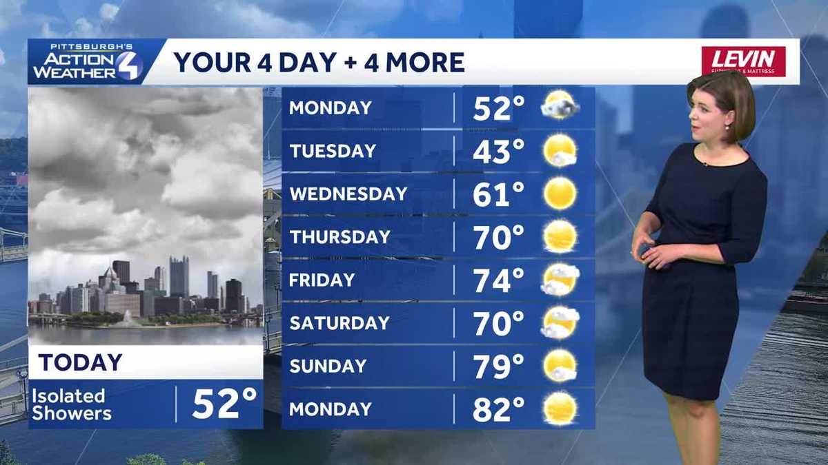
ACCORDING TO INVESTIGATORS. COOL TEMPERATURES STICKING AROUND FOR THIS EASTER MONDAY. IN FACT, WE HAVE A COUPLE MORE COOL DAYS FROSTY NIGHTS AHEAD AS WE GET THIS FIRST FULL WEEK OF APRIL. STARTED ALONG FOR THE RIDE TODAY. ALSO SOME SPOTTY SHOWERS, EVEN A FEW WET SNOWFLAKES FOR THOSE OF YOU UP ALONG I-80. OVERALL, FAR FROM A WASHOUT, BUT WE MAY HAVE TO DODGE A FEW MORE RAINDROPS INTO THE AFTERNOON. EVENTUALLY, THOUGH, SOME BRIGHTER AND WARMER DAYS ARE IN STORE. PRETTY NICE. SPRING FORECAST IS IN THE WORKS TOWARDS THE END OF THIS WEEK. WAKE UP TEMPERATURES RIGHT NOW IN THE UPPER 30S FOR MOST OF US. 39 IN PITTSBURGH, GREENSBURG 237 CRANBERRY, INDIANA TOUCH COOLER. AS WE CHECK INTO WASHINGTON. JUST 35 THIS MORNING. HERE’S A BREAKDOWN OF YOUR 4-DAY PLUS 4 MORE FORECAST 52 TODAY. SO FEELING VERY SIMILAR TO HOW YESTERDAY GOT STARTED AGAIN. WE’LL SEE THOSE ISOLATED SHOWERS ONCE WE MOVE THIS SYSTEM OUT. IT BRINGS IN A FRESH BATCH THAT’S SEASONABLY CHILLY AIR. DON’T LOVE TO TALK ABOUT THIS. HIGHS ONLY IN THE 40S TOMORROW, BUT WE DO GAIN SUNSHINE. SUNSHINE STAYS ON REPEAT AS OUR TEMPERATURES SURGE INTO THE 60S. EVEN THE 70S AND EVEN BY NEXT WEEKEND, POSSIBILITY THAT A FEW MORE 80S WILL BE SHOWING UP IN YOUR 4-DAY PLUS 4 MORE FORECAST. RIGHT NOW, ALL IS QUIET ACROSS THE CITY OF PITTSBURGH. GREAT SHOT WITH ACTION CAM HERE THIS MORNING. FIRST THEY WILL NOTICE, ESPECIALLY AS THE SUN IS WAKING UP THIS MORNING. IT’S MORE CLOUDS WILL BE SHIFTING IN. HERE’S THAT DISTURBANCE ARRIVING AS EARLY AS AT TEN, 11:00 THIS MORNING. LOOKS A LITTLE ROBUST IN TERMS OF THOSE SNOW CHANCES, BUT I THINK THERE WILL BE SOME WET SNOWFLAKES FLYING AGAIN FROM NEW CASTLE, POSSIBLY EVEN AS FAR SOUTH AS BUTLER AND KITTANNING. THAT’S PRIMARILY AN I-80 STORY. AS WE GET CLOSER TO THE CITY OF PITTSBURGH. JUST SOME QUICK PASSING, SPOTTY SHOWERS. WORK THROUGH THE LUNCH HOUR. EVEN THE EARLY PARTS OF THE AFTERNOON COULD BE THE CASE AS WELL. IN TIME FOR FIRST PITCH BETWEEN THE PIRATES AND THE PADRES. LAYERING UP A LITTLE BIT ONCE AGAIN TODAY FOR TONIGHT’S GAME, AS WE ARE EXPECTING THOSE COOL CONDITIONS TO LAST THROUGH THE OVERNIGHT INTO THE DAY. TOMORROW. EVENTUALLY. HIGH PRESSURE TAKES OVER AS WE’LL SEE MORE SUNSHINE FOR YOUR TUESDAY, SO SHADES WILL BE COMING INTO EFFECT AS WE GO THROUGH THE SECOND HALF OF THE WEEK, BUT CERTAINLY A CHILLY ONE TOMORROW. WE START AROUND 30 HIGH TEMPERATURES, THOUGH ONLY IN THE LOWER 40S AS WE GO THROUGHOUT THE DAY. THERE IS GOING TO BE A BIT OF A BREEZE TOO, SO THAT WILL ADD TO THOSE. FEELS LIKE TEMPERATURES THAT MORE THAN LIKELY ARE GOING TO BE IN THE 30S. FOR THE BETTER PART OF YOUR TUESDAY. JUST GET THROUGH TOMORROW. THINGS WILL BE GETTING BETTER. POSSIBILITY OF SOME FROST AND FREEZE ALERTS WEDNESDAY MORNING. THE GROWING SEASON HAS BEGUN FROM I-70 ON SOUTH. SO AGAIN, SOMETHING TO KEEP IN MIND IF YOU HAVE STARTED A GARDEN OR FOR SOME OF THE PLANTS THAT MAY ALREADY BE STARTING TO BLOSSOM 70 DEGREES BY THURSDAY. WE KEEP THE SPRINGLIKE TEMPERATURES GOING FRIDAY INTO THE UPCOMING WEEKEND. WILL WATCH THE POTENTIAL FOR A FEW SHOWERS, MAYBE FRIDAY NIGHT INTO SATURDAY. THE TIMING STILL A LITTLE UP IN THE AIR. OTHERWISE WE’
Pittsburgh: Seasonably chilly start to the week
Temperatures begin warming back up on Wednesday.

Updated: 4:56 AM EDT Apr 6, 2026
The cool air lingers for a couple more days. Isolated showers will develop late this morning through the afternoon. That is it for rain during the work week. A stretch of sunny and warmer days are ahead.Cool with isolated showersThe new week begins on a dry note. A quick passing system will usher in more clouds and eventually isolated showers. Activity will pop up as early as 10 or 11 a.m. and could include wet snowflakes closer to I-80. The sporadic showers will continue around western Pennsylvania through this evening.It will be another cool and breezy day with highs around 50 degrees.Cool days, frosty nightsA reinforcing dose of seasonably chilly air arrives behind today’s disturbance. Temperatures will dip into the 20s overnight. There won’t be much of a warm up tomorrow with highs in the lower 40s. But, sunshine will take over by the afternoon. High pressure will keep the clouds away through the middle of the week.Spring warmth returnsHigh temperatures return to the 60s on Wednesday and will continue to trend into the 70s. The warm up could even push the mercury into the low 80s over the weekend. We will watch another front coming out of the Great Lakes. A few more April showers are possible Friday or Saturday. We will continue to monitor the timing so you can make some plans outside this weekend.TODAY: Increasing clouds with isolated showers. Cool and breezy, high: 52°.TONIGHT: Mostly cloudy and colder. Low: 30°.TUESDAY: Chilly with a brisk breeze. Becoming mostly sunny. High: 43°, low: 26°.WEDNESDAY: Frosty morning, pleasant afternoon with plenty of sun. High: 61°, low: 39°.THURSDAY: Mostly sunny and warmer. High: 70°, low: 48°.
PITTSBURGH —
The cool air lingers for a couple more days. Isolated showers will develop late this morning through the afternoon. That is it for rain during the work week. A stretch of sunny and warmer days are ahead.
Cool with isolated showers
The new week begins on a dry note. A quick passing system will usher in more clouds and eventually isolated showers. Activity will pop up as early as 10 or 11 a.m. and could include wet snowflakes closer to I-80. The sporadic showers will continue around western Pennsylvania through this evening.
It will be another cool and breezy day with highs around 50 degrees.
Cool days, frosty nights
A reinforcing dose of seasonably chilly air arrives behind today’s disturbance. Temperatures will dip into the 20s overnight. There won’t be much of a warm up tomorrow with highs in the lower 40s. But, sunshine will take over by the afternoon. High pressure will keep the clouds away through the middle of the week.
Spring warmth returns
High temperatures return to the 60s on Wednesday and will continue to trend into the 70s. The warm up could even push the mercury into the low 80s over the weekend. We will watch another front coming out of the Great Lakes. A few more April showers are possible Friday or Saturday. We will continue to monitor the timing so you can make some plans outside this weekend.
TODAY: Increasing clouds with isolated showers. Cool and breezy, high: 52°.
TONIGHT: Mostly cloudy and colder. Low: 30°.
TUESDAY: Chilly with a brisk breeze. Becoming mostly sunny. High: 43°, low: 26°.
WEDNESDAY: Frosty morning, pleasant afternoon with plenty of sun. High: 61°, low: 39°.
THURSDAY: Mostly sunny and warmer. High: 70°, low: 48°.