
IMPACT: Freeze warning threatens plants, crops across the Susquehanna Valley
FERREIRA. GOOD MORNING. IT IS GOING TO BE A COLD ONE TONIGHT. LET ME SHOW YOU THIS FREEZE WARNING ISSUED BY THE NATIONAL WEATHER SERVICE FOR ALL COUNTIES IN THE SUSQUEHANNA VALLEY THAT GOES FROM MIDNIGHT UNTIL 9 A.M. TOMORROW. SO EVERYBODY IS INCLUDED, AND WE SHOULD BE SLIDING INTO THE 20S TONIGHT WITH CLEAR SKIES AND DIMINISHING WINDS. SO LOOK AT THESE LOW SOME SPOTS, LOWER 20S, ESPECIALLY FAR NORTHWEST MID 20S FOR MOST OF THE SUSQUEHANNA VALLEY. SO THIS IS A HARD FREEZE. YOU WANT TO COVER ANY SENSITIVE VEGETATION OR CROPS, ESPECIALLY KEEPING AN EYE ON THOSE FRUIT TREES. IF THEY’VE ALREADY BLOOMED. NOW AS WE HEAD INTO TOMORROW NIGHT. SO THURSDAY MORNING, EARLY THURSDAY, WE DO HAVE A FREEZE WATCH IN EFFECT FOR THE SUSQUEHANNA VALLEY. SO TWO BACK TO BACK NIGHTS, EARLY MORNINGS WHERE TEMPERATURES ARE GOING TO BE AT OR BELOW FREEZING. TODAY, OUR NEWS EIGHT STORM TEAM FORECAST STARTS OUT WITH CLEARING SKIES. IT’S GOING TO BE TURNING WINDY BEHIND A COLD FRONT. WE ONLY GET TO 48 DEGREES TODAY. THAT IS WELL BELOW OUR AVERAGE MARK OF 60. AND WITH THE BREEZE YOU KNOW IT’S GOING TO FEEL CHILLY. IT’S GOING TO FEEL LIKE THE 30S BY THE TIME WE GET THIS EVENING TONIGHT, DIMINISHING WINDS AS HIGH PRESSURE BUILDS IN. IT’S AN IMPACT NIGHT FOR THE FREEZE WARNING. IN EFFECT. LOOK AT THOSE 20 DEGREE TEMPERATURE RANGES. AND AS WE HEAD INTO TOMORROW, PLENTIFUL SUNSHINE, HIGH PRESSURE SMACK DAB OVERHEAD, CALMER AND COOL WITH HIGHS IN THE 50S FOR TOMORROW. STILL A BIT BELOW AVERAGE. RIGHT NOW IT’S 39 IN LEWISTOWN, 43 IN HARRISBURG, 42 IN LANCASTER. WE ADD A BIT OF A BREEZE, ESPECIALLY IN LEWISTOWN AT 40MPH. IT ALREADY FEELS LIKE THE 30S. SO A CHILLY MORNING THIS MORNING, BUT EVEN COLDER TOMORROW MORNING. WEATHER IN HEALTH UPDATE TODAY OUR TREE POLLEN LEVELS ARE HIGH. AIR QUALITY IS LOOKING GOOD AND THE UV INDEX IS MODERATE WITH A BURN TIME OF ABOUT 35 MINUTES. NOW WE HAVE A COLD FRONT COMING THROUGH RIGHT NOW. ASIDE FROM A SPRINKLE, I DON’T SEE MUCH ACTION ON THE RADAR. HOWEVER, TO OUR NORTH, THOSE ARE SNOW SHOWERS MOVING BY ACROSS NORTHERN PENNSYLVANIA INTO THE NORTHEAST. IT JUST SHOWS YOU THE STRENGTH OF THE COLD AIR COMING IN. SO FOR TODAY, ANY MORNING CLOUDS VANISH AS WE HEAD INTO THE AFTERNOON. WE GET THAT WALL TO WALL SUNSHINE. BUT IT’S BREEZY. IT’S WINDY AND IT’S COLD. TOMORROW. WE START OUT IN THE 20S AND THEN CLIMB TO THE 50S FOR OUR HIGHS. WITH THE HELP OF FULL SUNSHINE. IT GETS EVEN WARMER ON THURSDAY. WE’LL SEE A LITTLE BIT MORE CLOUD COVER, CALLING IT PARTLY SUNNY HERE, BUT THURSDAY’S HIGHS SHOULD TOUCH THE 60 MARK. GETTING WARMER EVEN THAN THAT. WE’RE GOING UP TO 70 DEGREES ON FRIDAY. SO IT IS A POTPOURRI OF TEMPERATURES HERE FROM THE 40S, 50S, 60S AND 70S ALL WEEK LONG. YOU JUST HAVE TO KEEP SHEDDING LAYERS AS THE WEEK GOES ON, SATURDAY WILL FEATURE A SLIM CHANCE OF A SHOWER EARLY IN THE MORNING AS A COLD FRONT COMES IN. WE’RE AT 60 FOUR S
IMPACT: Freeze warning threatens plants, crops across the Susquehanna Valley

Updated: 7:12 AM EDT Apr 7, 2026
Temperatures are expected to drop, potentially damaging plants and crops across the Susquehanna Valley. What to know The National Weather Service issued a freeze warning for all counties in south-central Pennsylvania in effect from midnight to 9 a.m. on Wednesday. The WGAL News 8 Storm Team has also declared an Impact Period for those hours.A freeze watch was also issued for all counties from midnight to 9 a.m. on Thursday. Protect your plants Because of warmer-than-average temperatures in March and early April, the growing season started early in south-central Pennsylvania. The NWS warns that sensitive crops and vegetation could be damaged as temperatures fall into the 20s and low 30s. Residents are advised to protect plants and flowers over the next two nights by covering them or bringing them indoors. Tuesday: Cool and windy Skies will clear Tuesday morning behind a cold front. Northwest winds will range from 15 to 25 mph, with gusts up to 35 mph in the afternoon. High temperatures will reach the upper 40s, but it will feel chilly because of the wind. Overnight lows will fall into the low-to-mid 20s in northern areas and the mid-to-upper 20s in southern areas. Winds will ease overnight as high pressure moves in from the Midwest. Wednesday: Sunny and calmerWednesday will be sunny and calmer as high pressure settles overhead. High temperatures will reach the low to mid-50s. Temperatures will be warmer than Tuesday but still below the average of 60 degrees. Lows will drop below freezing again on Wednesday night. Thursday/Friday: Warmer temperatures returnWarmer weather returns as winds shift to the southeast. Highs in the low 60s Thursday and low 70s Friday. Partly sunny skies and light winds are expected both days. SOUTH-CENTRAL PA WEATHER RESOURCES: INTERACTIVE RADAR | ACTIVE WEATHER ALERTS | CURRENT CONDITIONS | HOURLY FORECAST | 10-DAY FORECAST | WEEKEND FORECAST | MAP ROOM | DOWNLOAD THE APP | WEATHER EMAILS
Temperatures are expected to drop, potentially damaging plants and crops across the Susquehanna Valley.

What to know
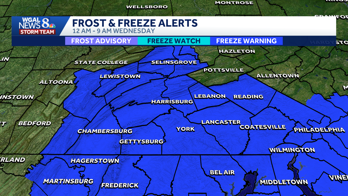
The National Weather Service issued a freeze warning for all counties in south-central Pennsylvania in effect from midnight to 9 a.m. on Wednesday.
The WGAL News 8 Storm Team has also declared an Impact Period for those hours.

A freeze watch was also issued for all counties from midnight to 9 a.m. on Thursday.

Protect your plants
Because of warmer-than-average temperatures in March and early April, the growing season started early in south-central Pennsylvania.
The NWS warns that sensitive crops and vegetation could be damaged as temperatures fall into the 20s and low 30s.
Residents are advised to protect plants and flowers over the next two nights by covering them or bringing them indoors.

Tuesday: Cool and windy Skies will clear Tuesday morning behind a cold front. Northwest winds will range from 15 to 25 mph, with gusts up to 35 mph in the afternoon. High temperatures will reach the upper 40s, but it will feel chilly because of the wind. Overnight lows will fall into the low-to-mid 20s in northern areas and the mid-to-upper 20s in southern areas. Winds will ease overnight as high pressure moves in from the Midwest.


Wednesday: Sunny and calmerWednesday will be sunny and calmer as high pressure settles overhead. High temperatures will reach the low to mid-50s. Temperatures will be warmer than Tuesday but still below the average of 60 degrees. Lows will drop below freezing again on Wednesday night.

Thursday/Friday: Warmer temperatures returnWarmer weather returns as winds shift to the southeast. Highs in the low 60s Thursday and low 70s Friday. Partly sunny skies and light winds are expected both days.
SOUTH-CENTRAL PA WEATHER RESOURCES: INTERACTIVE RADAR | ACTIVE WEATHER ALERTS | CURRENT CONDITIONS | HOURLY FORECAST | 10-DAY FORECAST | WEEKEND FORECAST | MAP ROOM | DOWNLOAD THE APP | WEATHER EMAILS