
FREEZE WARNING ISSUED: Plunging temperatures return to PA; When it’s expected to warm up
OUR GALAXY, THE MILKY WAY. NOW, THE WGAL NEWS EIGHT STORM TEAM FORECAST WITH METEOROLOGIST MIKE SUSKO. GOOD AFTERNOON EVERYONE, AND ONCE AGAIN TONIGHT WE WILL HAVE A FREEZE WARNING THAT WILL GO INTO EFFECT FOR THE ENTIRE SUSQUEHANNA VALLEY AS TEMPERATURES WILL DROP BELOW 32 DEGREES. SO IF YOU HAVE ANY PLANTS OUTSIDE, MAKE SURE YOU COVER THEM UP OR BRING THEM INSIDE OVERNIGHT TONIGHT AS LOWS WILL DROP DOWN TO AROUND 30 DEGREES IN THE UPPER 20S ACROSS THE ENTIRE REGION. HERE, THE ONLY EXCEPTION MAYBE WILL BE CHAMBERSBURG AND GETTYSBURG, BUT STILL IN AREAS SURROUNDING THOSE AREAS MAY END UP GETTING BELOW FREEZING. SO YOU STILL WANT TO COVER THEM UP TONIGHT, ESPECIALLY IN LEBANON, ONE OF THE PLACES THAT COULD GET DOWN INTO THE UPPER 20S ACROSS THE REGION IS PARTS OF LEBANON COUNTY. PLENTY OF BLUE SKY. AT THE MOMENT, THOUGH, IT’S JUST A LITTLE BIT ON THE COOL SIDE. 40 DEGREES IN HARRISBURG, 42 RIGHT NOW IN LEBANON, AS WELL AS CARLISLE, LANCASTER RIGHT IN BETWEEN AT 41, 43 FOR CHAMBERSBURG AND 46 IN GETTYSBURG. THAT IS THE WARM SPOT. BUT HERE’S A LOOK AT LIVE RADAR NETWORK HIGH PRESSURES. NEARBY. WE GOT BLUE SKY, PLENTY OF SUNSHINE. SO TEMPERATURES LATER ON TODAY WILL BE ON. THE WARMING TREND WILL BE GOING UP TO AROUND THE LOW TO MID 50S TODAY. SO IF YOU WANT TO DO ANY SPRINGTIME YARD CLEANUP YES IT’S A LITTLE BIT COOL. IT’S BELOW AVERAGE, BUT IT’S GOT A NICE DAY TO DO IT. SO AND IT’S NOT WINDY. YESTERDAY WAS WINDY TODAY. IT’S NOT ACROSS THE REGION. TONIGHT WE DROP BACK TO THAT UPPER 20S AND LOW 30S FOR THOSE LOWS. CLEAR SKY, COMMON COLD WITH THAT FREEZE WARNING GOING INTO EFFECT TOMORROW. PARTLY SUNNY. A SEASONABLE DAY WILL ACTUALLY BE RIGHT AROUND AVERAGE, WHICH IS 61 THIS TIME OF YEAR. AND WE’LL BE RIGHT AROUND THAT WITH A LITTLE BIT MORE CLOUD COVER, BUT STILL PLENTY OF SUNSHINE ACROSS THE AREA. HERE’S A LOOK AT THE PREDICTOR AS WE GO THROUGH THE DAY. HIGH PRESSURE STILL IN CONTROL. BRINGING US THAT BIG BLUE SKY AS WE HEAD INTO TOMORROW. A LITTLE MORE CLOUD COVER, BUT WE’RE STILL DRY. A LITTLE BIT OF MOISTURE MOVES INTO THE NORTHWEST PENNSYLVANIA, BUT UNFORTUNATELY IT’S TOO DRY HERE FOR IT TO MAKE ALL THE WAY INTO THE SUSQUEHANNA VALLEY. AS WE HEAD INTO YOUR FRIDAY, FRIDAY MORNING AND AFTERNOON. LOOKING GOOD. A COLD FRONT WILL APPROACH THE AREA FRIDAY NIGHT AND OFFER US A SPOTTY SHOWER AS WE HEAD INTO SATURDAY EARLY MORNING. BUT THAT’S OUR BEST CHANCE HERE TO GET SOME RAIN WITHIN THE NEXT COUPLE OF DAYS FOR THE SUSQUEHANNA VALLEY. SO WE’RE STILL GOING TO BE IN THAT DRY STRETCH REALLY THROUGH THE WEEKEND. SO IF YOU’RE LOOKING AT SATURDAY AND SUNDAY HERE, GREAT DAYS TO GET OUT HERE. WE’LL BE SEEING THOSE TEMPERATURES AROUND 64. SATURDAY 68. BY THE TIME WE GET TO YOUR SUNDAY HERE, MAYBE YOU WANT TO GO OUT AND HIT THE LINKS IF YOU CAN. THIS WEEKEND AS WE TAKE A LOOK AT THE TEN DAY FORECAST NEXT WEEK, IT’S WARMER AND WE ALSO SEE RAIN CHANCES. AT LEAST GO UP A LITTLE BIT. WE’LL GET UP TO 80 DEGREES BY NEXT MONDAY, AND TUESDAY WILL BE IN THE 80S, THE FIRST TIME WE’LL SEE BACK TO BACK 80S THIS YEAR SO FAR. AND THEN IN THE 70S FOR WEDNESDAY AND THURSDAY OF NEXT WEEK. BEFO
FREEZE WARNING ISSUED: Plunging temperatures return to PA; When it’s expected to warm up

Updated: 1:04 PM EDT Apr 8, 2026
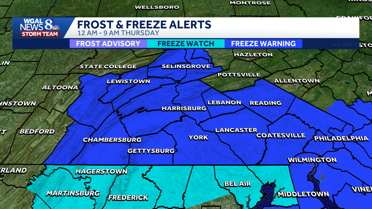
The National Weather Service issued a freeze warning for all of south-central Pennsylvania as plunging temperatures could damage crops and sensitive plants. The warning will take effect from midnight through 9 a.m. Thursday. The WGAL News 8 Storm Team also declared an Impact during those times, meaning the weather will likely disrupt your normal daily schedule or routine. What to expect Overnight low temperatures will drop to the upper 20s and low 30s. Frost may develop before sunrise on Thursday. ImpactsThe growing season started early due to warmer-than-average temperatures in March and early April. Sensitive plants and crops could be damaged or killed. Unprotected outdoor plumbing could also be affected. PrecautionsCover sensitive vegetation and early-season crops. Bring potted plants indoors. Take precautions for exposed outdoor plumbing. When will the warmth return? Warmer temperatures return Thursday (highs in the mid-60s) and Friday (highs in the low 70s) as winds shift to the southeast. Sunday stays mild: Highs rebound to around 68 after a cooler Saturday. Even warmer early next week: Highs near 80 on Monday. Peak warmth Tuesday: Temperatures climb into the low 80s. SOUTH-CENTRAL PA WEATHER RESOURCES: INTERACTIVE RADAR | ACTIVE WEATHER ALERTS | CURRENT CONDITIONS | HOURLY FORECAST | 10-DAY FORECAST | WEEKEND FORECAST | MAP ROOM | DOWNLOAD THE APP | WEATHER EMAILS
The National Weather Service issued a freeze warning for all of south-central Pennsylvania as plunging temperatures could damage crops and sensitive plants.
The warning will take effect from midnight through 9 a.m. Thursday.
The WGAL News 8 Storm Team also declared an Impact during those times, meaning the weather will likely disrupt your normal daily schedule or routine.

What to expect Overnight low temperatures will drop to the upper 20s and low 30s. Frost may develop before sunrise on Thursday.

ImpactsThe growing season started early due to warmer-than-average temperatures in March and early April. Sensitive plants and crops could be damaged or killed. Unprotected outdoor plumbing could also be affected.

PrecautionsCover sensitive vegetation and early-season crops. Bring potted plants indoors. Take precautions for exposed outdoor plumbing. When will the warmth return? Warmer temperatures return Thursday (highs in the mid-60s) and Friday (highs in the low 70s) as winds shift to the southeast. Sunday stays mild: Highs rebound to around 68 after a cooler Saturday. Even warmer early next week: Highs near 80 on Monday. Peak warmth Tuesday: Temperatures climb into the low 80s.


SOUTH-CENTRAL PA WEATHER RESOURCES: INTERACTIVE RADAR | ACTIVE WEATHER ALERTS | CURRENT CONDITIONS | HOURLY FORECAST | 10-DAY FORECAST | WEEKEND FORECAST | MAP ROOM | DOWNLOAD THE APP | WEATHER EMAILS