
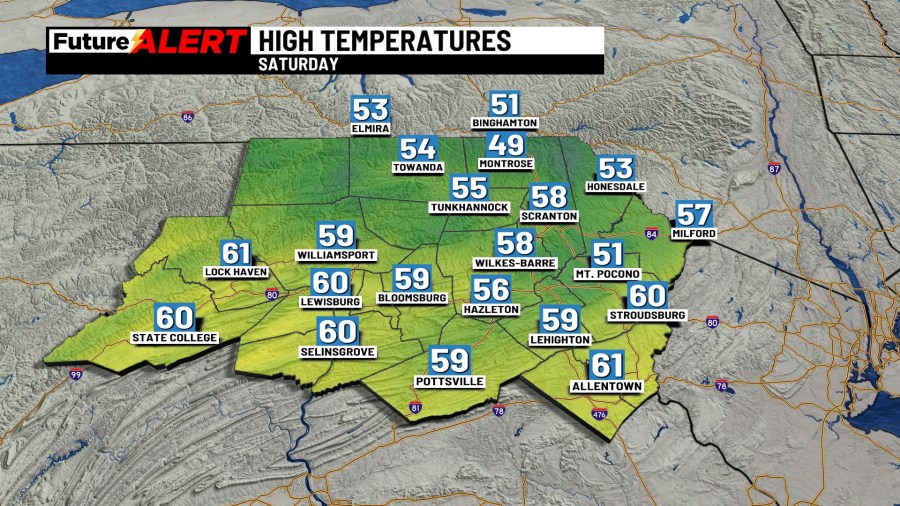
(WBRE/WYOU) — We saw some rain last night, but that isn’t going to be the case today. We will see sunshine and more seasonable weather for your Saturday. It will start off partly to mostly cloudy before turning mostly sunny by afternoon. It can be breezy at times. Highs will be in the middle and upper 50s. For tonight, it will be mostly clear and colder with lows into the low and middle 30s. The seasonable and chilly weather won’t last for very long.
For Sunday, there will be partly to mostly cloudy skies with the chance of a shower late, especially in areas more north. Highs will be in the upper 50s and low 60s. A push of warmer air will come through Sunday night and Monday, allowing for some warmer weather for next workweek! With this warm front, we can see mostly cloudy skies and the chance for some showers on Monday. Afternoon highs will be in the low to middle 70s.
Tuesday through Thursday features some unseasonably warm weather and partly to mostly cloudy skies. There is a slight chance of a shower each day, so many areas could stay completely dry for multiple days. Highs will be in the upper 70s and low 80s, and even the middle 80s in its warmest spots. Overnight lows will also be very warm for this time of year — upper 50s and low 60s! A weak cold front could come through later Thursday and Thursday night, dropping temperatures a few degrees for Friday. Some uncertainty exists towards the end of the week, but it looks to still stay warm and even muggy through the end of the week with highs into the low and middle 70s for Friday. Great weather to be outside!
Copyright 2026 Nexstar Media, Inc. All rights reserved. This material may not be published, broadcast, rewritten, or redistributed.
For the latest news, weather, sports, and streaming video, head to 28/22 News.