
Dry & comfy weekend, then summerlike warmth for next week across south-central Pennsylvania
Frost Advisory goes in effect tonight from 2 AM – 8 AM. Then, another day of slightly above average temps for tomorrow afternoon. Temperatures make a run for the 80s next week with very minimal rain chances for the next several days.
CONSTRUCTION AND LATER PAUSED THAT ORDER FOR 14 DAYS. NOW, THE WGAL NEWS EIGHT STORM TEAM FORECAST WITH METEOROLOGIST BRIAN ARGENTINE WEATHER HEADLINES AS WE HEAD INTO THE SECOND HALF OF THE WEEKEND STILL LOOKING PLEASANT, LOOKING DRY. IT’S GOING TO BE COMFY, WILL BE SEASONABLE INTO THE 60S. LOOKING AHEAD INTO THE WEEK, THOUGH, WE’RE GOING TO BE FEELING LIKE SUMMER FOLKS AS WE GET INTO OUR TUESDAY AND THURSDAY, ESPECIALLY WITH HIGHS GETTING INTO THE 80S, WE COULD POTENTIALLY SEE SOME RECORD CHALLENGING TEMPERATURE HIGH TEMPERATURES FOR OUR WEDNESDAY, WHICH WILL SHOW YOU THAT IN THE TEN DAY FORECAST HERE IN A FEW MINUTES. BUT WE’LL BE SEEING A MAINLY DRY STRETCH AS WE HEAD INTO THE NEXT SEVERAL DAYS, 7 TO 10 DAYS, REALLY VERY LOW CHANCE OF SOME SHOWERS. THE NEXT BEST CHANCE OF SHOWERS I THINK IS GOING TO BE NEXT NEXT WEEKEND. BUT AGAIN, WE’LL CHAT ABOUT THAT HERE IN A SECOND. SO TEMPERATURES TODAY THOUGH HIT RIGHT AROUND 66 DEGREES. 62 IS WHAT WE EXPECT FOR THIS TIME OF THE YEAR 53. THAT WAS EARLIER THIS MORNING. THIS MORNING’S LOWS RIGHT AROUND 53. WE EXPECT 41 FOR THIS TIME OF YEAR. AS YOU CAN SEE, WE’RE A BIT MILD FOR THIS TIME OF THE YEAR. NO RAINFALL RECORDED AT HARRISBURG INTERNATIONAL AIRPORT. SO OVERNIGHT TONIGHT WE HAVE CLEAR SKIES. IT WILL BE CHILLY AND CALM, BUT WE DO HAVE A FROST ADVISORY. WE’RE GOING TO CHAT ABOUT THAT HERE. BUT WE HAVE MADE IT AN IMPACT NIGHT FROM 2 A.M. TILL 8 A.M. FOR FOR A LIST OF SOME COUNTIES. I’LL CHAT ABOUT THAT HERE IN JUST A SECOND, 32 TO 36 DEGREES OVERNIGHT, 44 TO 52 FOR TOMORROW MORNING. IT’S GOING TO BE A BIT OF A QUICK WARM UP. I THINK WE’LL SEE A WIDE TEMPERATURE RANGE FOR TOMORROW MORNING. WE’LL SEE SOME INCREASING WINDS OUT OF THE SOUTHEAST WITH MOSTLY SUNNY SKIES. THEN WE’LL START TO SEE SOME CLOUDS INCREASE. WE’LL SEE PARTLY SUNNY CONDITIONS STILL STILL COMFY. A LITTLE BIT BREEZY OUT THERE WITH THAT SOUTHEASTERLY BREEZE AND 62 TO 66 DEGREES FOR THE AFTERNOON. SO TOMORROW POLLEN LEVELS THEY’RE GOING TO BE HIGH FROM THE TREES. MOLD LEVELS ARE GOING TO BE LOW. MODERATE AIR QUALITY AND MODERATE UV INDEX GOT ABOUT A 30 MINUTE BURN TIME. BUT HERE’S TEMPERATURES AT THIS TIME ARE 50 IN HARRISBURG, 50 IN LANCASTER, 54 IN GETTYSBURG, 48 IN LEWISTOWN. BUT NOTICE THE TEMPERATURES AS WE GO THROUGH THE NEXT SEVERAL HOURS. YOU COULD SEE BRIEFLY, WE WERE INTO THE 30S. THE RANGE KIND OF WENT A LITTLE AHEAD OF WHERE I EXPECTED. BUT THAT’S WHY BECAUSE WE HAVE TEMPERATURES GETTING INTO THE LOWER 30S. BUT BETWEEN 34 AND 36 DEGREES, THERE IS THE CHANCE FOR SEEING SOME FROST ACROSS PORTIONS OF THE VALLEY, AND MORE SPECIFICALLY FOR MIFFLIN, JUNIATA, PERRY COUNTIES, DAUPHIN COUNTY, LEBANON COUNTY AND LANCASTER COUNTY. YOU’RE GOING TO BE SEEING SOME TEMPERATURES GETTING DOWN INTO THE LOWER, LOWER 30S RANGE. NOW YOU SEE FRANKLIN, CUMBERLAND, ADAMS AND YORK COUNTIES NOT HIGHLIGHTED HERE IN THE FROST ADVISORY. THAT’S BECAUSE THE TEMPERATURES AREN’T AT THE THRESHOLD OF THE FROST ADVISORY, ACCORDING TO THE NATIONAL WEATHER SERVICE. SO THAT’S WHY YOU’RE SEEING IF YOU’RE LIVING IN FRANKLIN, CUMBERLAND, ADAMS OR YORK AND YOU’RE TUNING IN, THAT’S THE REASON WHY. BUT JUST MAKE SURE THAT YOU KEEP THIS IN MIND AS WE GO THROUGH THE NIGHT TONIGHT, IF YOU HAVEN’T DONE IT NOW, I WOULD TAKE JUST A FEW MINUTES, COVER YOUR SENSITIVE PLANTS, YOUR CROPS, YOUR VEGETATION. IF YOU’VE ALREADY PLANTED YOUR YOUR SMALL FLOWERS IN YOUR FLOWERBEDS ALREADY, I WOULD JUST PUT A BLANKET OVER TOP OR SOME TYPE OF TARP OVER TOP OF IT. SO THAT WAY IT PROTECTS IT FROM THE FROST THAT WILL DEVELOP. BUT WE’RE BRINGING ANY POTTED PLANTS INSIDE. YOU CAN SEE WINDS HAVE CALMED FOR THE MOST PART, BUT WE WILL START TO SEE THAT BREEZE BEGIN TO INCREASE AS WE HEAD INTO TOMORROW AFTERNOON AND TOMORROW EVENING. STORM TEAM LIVE RADAR NETWORK JUST SEEING MAINLY CLEAR CONDITIONS THANKS TO HIGH PRESSURE THAT SETTLED IN OVER THE AREA. AND WE’LL CONTINUE TO SEE HIGH PRESSURE SETTLE IN OVERHEAD. AND YOU CAN SEE WE’LL SEE MAINLY CLEAR CONDITIONS AS WE HEAD INTO AS WE HEAD INTO THE SECOND HALF OF THE WEEKEND, STILL PARTLY SUNNY AND COMFY, 76 DEGREES FOR YOUR MONDAY. THERE IS A CHANCE OF SOME SHOWERS, BUT IT WILL BE LATER IN THE DAY. LATER IN THE EVENING I SHOULD SAY. AS WE GET INTO MONDAY. FEELING LIKE JUNE THOUGH, AS WE HEAD INTO OUR TUESDAY 82 DEGREES 86 FOR OUR WEDNESDAY. THAT’S NEAR RECORD WARMTH. THE RECORD FOR WEDNESDAY IS 87. BACK IN 1941. THAT’S SOMETHING THAT WE’RE GOING TO BE CLOSELY, CLOSELY WATCHING TO SEE IF TEMPERATURES GET TO THAT POINT, BUT STILL GOING TO BE FEELING VERY MUCH LIKE SUMMER. BUT THE NEXT BEST CHANCE
Dry & comfy weekend, then summerlike warmth for next week across south-central Pennsylvania
Frost Advisory goes in effect tonight from 2 AM – 8 AM. Then, another day of slightly above average temps for tomorrow afternoon. Temperatures make a run for the 80s next week with very minimal rain chances for the next several days.

Updated: 11:41 PM EDT Apr 11, 2026
Impact Night for FrostThe National Weather Service has issued a Frost Advisory for Lancaster, Lebanon, Dauphin, Mifflin, Juniata, & Perry counties from 2am Sunday until 8 am SundayTonight, expect clear skies and temperatures dropping at or just above freezing in some spots. This will allow the chance for frost to develop overnight in some communities, which is why for tonight, we are setting tonight as Impact for Mifflin, Juniata, Perry, Dauphin, Lebanon, & Lancaster counties from 2 am until 8 am Sunday morning. Be sure to cover any sensitive vegetation or tender plants outside, or if you have potted plants, be sure to bring them inside tonight. Any sensitive plants may be killed by the frost if precautions aren’t taken!By mid-morning, temperatures rise through the lower 50s & the pleasant weather sticks around Sunday afternoon with partly sunny conditions. Temperatures will top out in the lower to mid 60s.A shift into a warmer pattern begins Monday as highs jump into the upper 70s. Southwesterly winds bring in more cloud cover, and late day spotty showers can’t be ruled out, so it’s worth keeping an eye to the sky if you’re outside.We flip the switch to early summer with highs soaring into the mid 80s Tuesday through Thursday. We will challenge records on Wednesday. Forecast is 86 and the record is 87 set in 1941. You’ll notice an uptick in humidity with dew points near 60° Not oppressive by any means but enough to make it feel a bit sticky, especially in the afternoons. Rain chances remain low so great weather for outdoor plans.Our next cold front approaches late week and things begin to shift. It is still warm in the 80s Thursday, with a few showers possible. With the front east of the area, temperatures return to the 70s Friday and Saturday. The next best chance for showers is on Sunday. It’s not a washout but you may have to alter outdoor plans briefly. Highs will return to more seasonable averages in the 60s.Have a great rest of your night!~ Ryan
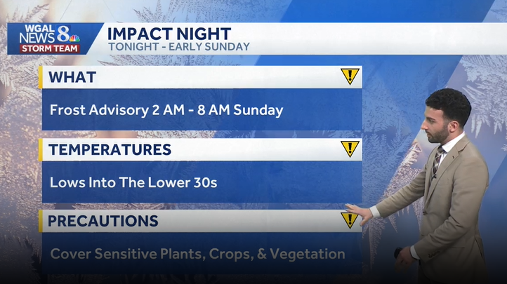
Impact Night for Frost
The National Weather Service has issued a Frost Advisory for Lancaster, Lebanon, Dauphin, Mifflin, Juniata, & Perry counties from 2am Sunday until 8 am Sunday
Tonight, expect clear skies and temperatures dropping at or just above freezing in some spots. This will allow the chance for frost to develop overnight in some communities, which is why for tonight, we are setting tonight as Impact for Mifflin, Juniata, Perry, Dauphin, Lebanon, & Lancaster counties from 2 am until 8 am Sunday morning. Be sure to cover any sensitive vegetation or tender plants outside, or if you have potted plants, be sure to bring them inside tonight. Any sensitive plants may be killed by the frost if precautions aren’t taken!
By mid-morning, temperatures rise through the lower 50s & the pleasant weather sticks around Sunday afternoon with partly sunny conditions. Temperatures will top out in the lower to mid 60s.
A shift into a warmer pattern begins Monday as highs jump into the upper 70s. Southwesterly winds bring in more cloud cover, and late day spotty showers can’t be ruled out, so it’s worth keeping an eye to the sky if you’re outside.
We flip the switch to early summer with highs soaring into the mid 80s Tuesday through Thursday. We will challenge records on Wednesday. Forecast is 86 and the record is 87 set in 1941. You’ll notice an uptick in humidity with dew points near 60° Not oppressive by any means but enough to make it feel a bit sticky, especially in the afternoons. Rain chances remain low so great weather for outdoor plans.
Our next cold front approaches late week and things begin to shift. It is still warm in the 80s Thursday, with a few showers possible. With the front east of the area, temperatures return to the 70s Friday and Saturday. The next best chance for showers is on Sunday. It’s not a washout but you may have to alter outdoor plans briefly. Highs will return to more seasonable averages in the 60s.
Have a great rest of your night!
~ Ryan