
The forecast is picking up right where the weekend left off with seasonal temperatures and sunshine. Shower chances return late Wednesday with an Impact Day on Thursday for rain and blustery conditions.Pleasant late October daysThe new work and school week begins with frosty and freezing temperatures. We will shake that chill fairly quickly. Today will be another sunny and seasonal day with highs closer to 60 degrees. More clouds are on the way late Tuesday into Wednesday, drawing highs back into the low and mid 50s.Tracking rain with an Impact Day on ThursdayShowers will return late Wednesday with widespread rain returning on Thursday, which is an Impact Day. It will also turn blustery as this system wraps through western Pennsylvania. Wind could gust up to 30 mph. Showers still look to linger into Friday morning. By the time rain exits, we could see over an inch of rain across western PA with most of that rain falling on Thursday.Cooler to begin NovemberTrick-or-treaters will have to deal with some eerie clouds and damp conditions Friday evening. We stay chilly into the first weekend of November with highs around 50 degrees. Another system will bring the potential for showers late in the weekend. Also, don’t forget to “fall back.” Daylight Saving Time ends at 2 a.m. Sunday.TODAY: Frosty start, seasonal afternoon with sunshine. High: 58°.TONIGHT: Mainly clear and chilly. Low: 37°.TUESDAY: Slightly cooler with more sun than clouds. High: 54°, low: 39°.WEDNESDAY: Turning clouds with late-day showers. Low: 52°, low: 43°.
PITTSBURGH —
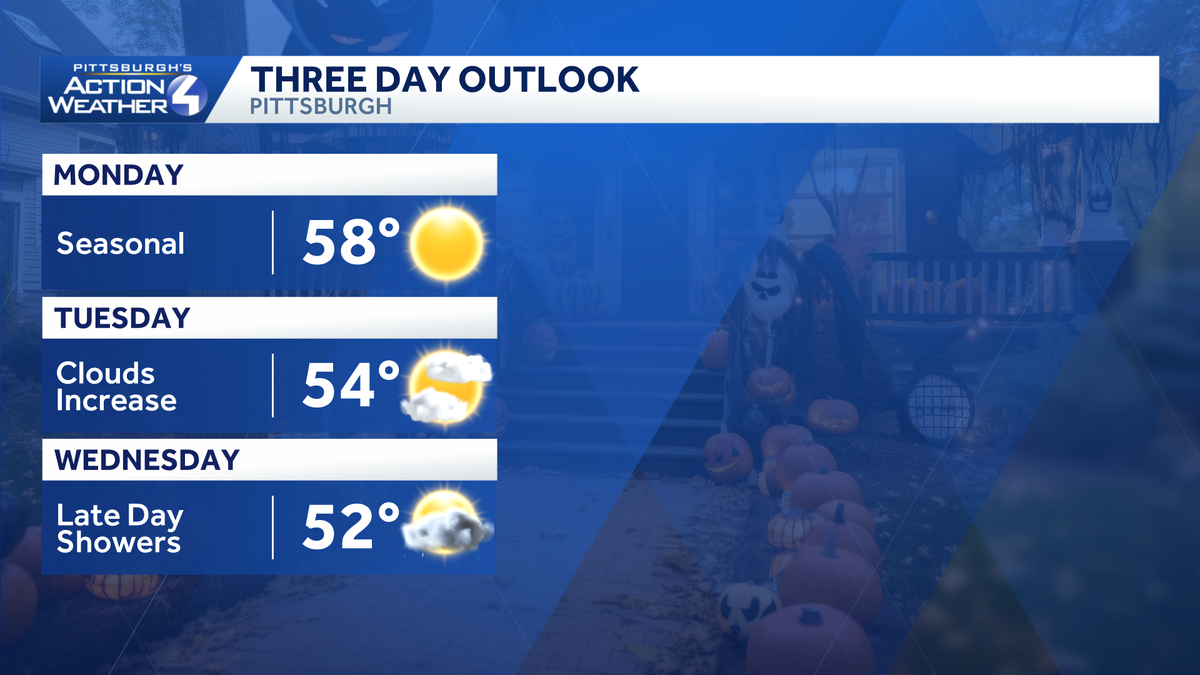
The forecast is picking up right where the weekend left off with seasonal temperatures and sunshine. Shower chances return late Wednesday with an Impact Day on Thursday for rain and blustery conditions.
Pleasant late October days
The new work and school week begins with frosty and freezing temperatures. We will shake that chill fairly quickly. Today will be another sunny and seasonal day with highs closer to 60 degrees. More clouds are on the way late Tuesday into Wednesday, drawing highs back into the low and mid 50s.

Hearst OwnedHearst
The dry stretch extends through the first half of Wednesday.
Tracking rain with an Impact Day on Thursday
Showers will return late Wednesday with widespread rain returning on Thursday, which is an Impact Day. It will also turn blustery as this system wraps through western Pennsylvania. Wind could gust up to 30 mph. Showers still look to linger into Friday morning. By the time rain exits, we could see over an inch of rain across western PA with most of that rain falling on Thursday.

Hearst OwnedHearst
Showers return late Wednesday. An Impact Day is head for Thursday with all-day rain and up to 30 mph gusts.
Cooler to begin November
Trick-or-treaters will have to deal with some eerie clouds and damp conditions Friday evening. We stay chilly into the first weekend of November with highs around 50 degrees. Another system will bring the potential for showers late in the weekend. Also, don’t forget to “fall back.” Daylight Saving Time ends at 2 a.m. Sunday.

Hearst OwnedHearst
Temperatures trend chillier to begin November over the weekend.
TODAY: Frosty start, seasonal afternoon with sunshine. High: 58°.
TONIGHT: Mainly clear and chilly. Low: 37°.
TUESDAY: Slightly cooler with more sun than clouds. High: 54°, low: 39°.
WEDNESDAY: Turning clouds with late-day showers. Low: 52°, low: 43°.