
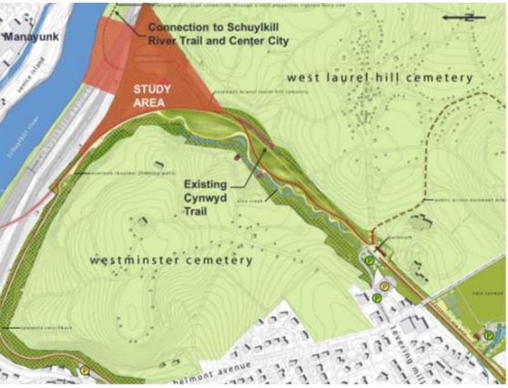
LOWER MERION – Lower Merion officials are planning to apply for a $500,000 grant to help with a major connection to link the existing Cynwyd Heritage Trail to the newly refurbished Norfolk Southern Tunnel.
During a committee meeting on April 9, the Lower Merion Board of Commissioners voted its support for a resolution to authorize township staff to submit the grant application to the DCNR Community Conservation Partnership Program.
The grant would help fund the development of a trail link connecting the existing Cywnyd trail to a newly improved tunnel beneath the Norfolk Southern Railroad. The new trail segment will link the Cynwyd Trail to the Pencoyd Bridge, which crosses into Manayunk.
According to township officials, Lower Merion had negotiated with Norfolk Southern for the 33-foot-wide easement between the township property and the river that passes under the Norfolk Southern railroad bridge. Now that the Norfolk Southern lease has been obtained and work on the railroad bridge is complete, the focus has shifted to the accessible trail connection from the Cynwyd Heritage Trail to the Norfolk Southern Tunnel.
The ideas for developing the trail date back over a decade.
“The Board received [the] Cynwyd Spur Trail Feasibility and Planning Study in 2015,” according to a staff memo to the commissioners. “This study determined the trail’s feasibility and construction options to connect the Cynwyd Heritage Trail (CHT) to the riverfront, which has an 80’ to 100’ grade differential. At that time the Righter’s Ferry residential development was constructing their riverfront trail and Pencoyd Bridge which connects directly to the Wissahickon Gateway and ultimately the Schuylkill River Trail.
During the meeting, Commissioner Louis Rossman expressed his support for the new trail link, pointing out that the area is very steep.
“I think this is such an important connection,” Rossman said. “We have the tunnel built. It’s sometimes an eye-opener what these things cost to build. But if you travel down that trail, you’ll see how steep it is, and to make it ADA specific, and you really have to grade it. You have to shore it up with walls, and it has to be probably switchbacks all the way down. That’ll make it gentle. But it is well used right now. And when you go down there, as I have several times, you see bikers coming through, and it’s quite dangerous to navigate at this point. You see runners coming through, but it’s a magical part of the trail, and it connects with the landing and everything else. And once it’s complete, it will be just a wonderful part of the township.