
Today is an Impact Day for the potential for a late-day thunderstorms. Summer-like temperatures are assisting the unsettled set-up through the end of the week.Impact Day: Afternoon storms northIsolated showers will be around throughout the day. We will monitor a wave of rain and embedded storms that will drop southward this afternoon and evening. The window opens up as early as 1 p.m or 2 p.m. to the northwest of Pittsburgh.The entirety of western Pennsylvania is included in today’s isolated severe storm threat, however a line near and north of PA Turnpike are most likely to catch one of the storms. Downpours and strong winds are the top threats from any thunderstorms. Activity will fizzle as sunset approaches.Near-record warmth WednesdayOutside of the daily showers chance, we are also tracking a surge of unseasonable warmth. We will see a string of 80-degree days. There will be a chance of tying a record high on Wednesday. We could also break the record for most mornings at or above 60° in April by the end of the week.More rain chances through the weekendMost of the unsettled weather will be confined north of Pittsburgh, closer to a boundary draped across the Great Lakes. The daily dose of showers will continue through Friday morning. A front will get a better push late Saturday with area-wide rain and dropping temperatures. High temperatures this weekend will go from the mid 80s on Saturday, then plunge into the 50s and 60s by Sunday. Temperatures will reset to more seasonal levels through the start of next week.TODAY – Impact Day: Spotty showers with late-day storms north. Breezy and warm. High: 81°.TONIGHT: Showers and storms fizzle. Staying warm, low: 65°.WEDNESDAY: Near-record warmth with isolated showers north. High: 84°, low: 66°.THURSDAY: Scattered rain late. Mostly cloudy and warm. High: 83°, low: 60°.FRIDAY: Leftover morning showers, then not as warm. High: 79°, low: 58°.
Today is an Impact Day for the potential for a late-day thunderstorms. Summer-like temperatures are assisting the unsettled set-up through the end of the week.
Impact Day: Afternoon storms north

Hearst OwnedHearst
Hit or miss showers this morning will be followed by isolated strong thunderstorms this afternoon and evening.
Isolated showers will be around throughout the day. We will monitor a wave of rain and embedded storms that will drop southward this afternoon and evening. The window opens up as early as 1 p.m or 2 p.m. to the northwest of Pittsburgh.

Hearst OwnedHearst
One of the isolated strong thunderstorms could arrive in Allegheny County as early as 3 p.m.
The entirety of western Pennsylvania is included in today’s isolated severe storm threat, however a line near and north of PA Turnpike are most likely to catch one of the storms. Downpours and strong winds are the top threats from any thunderstorms. Activity will fizzle as sunset approaches.
Near-record warmth Wednesday
Outside of the daily showers chance, we are also tracking a surge of unseasonable warmth. We will see a string of 80-degree days. There will be a chance of tying a record high on Wednesday. We could also break the record for most mornings at or above 60° in April by the end of the week.

Hearst OwnedHearst
Very summer-like Wednesday afternoon with near-record warmth for Pittsburgh.
More rain chances through the weekend
Most of the unsettled weather will be confined north of Pittsburgh, closer to a boundary draped across the Great Lakes. The daily dose of showers will continue through Friday morning. A front will get a better push late Saturday with area-wide rain and dropping temperatures.
High temperatures this weekend will go from the mid 80s on Saturday, then plunge into the 50s and 60s by Sunday. Temperatures will reset to more seasonal levels through the start of next week.

Hearst OwnedHearst
The summer-like conditions including unseasonably warmth and unsettled weather extend through the start of the weekend.
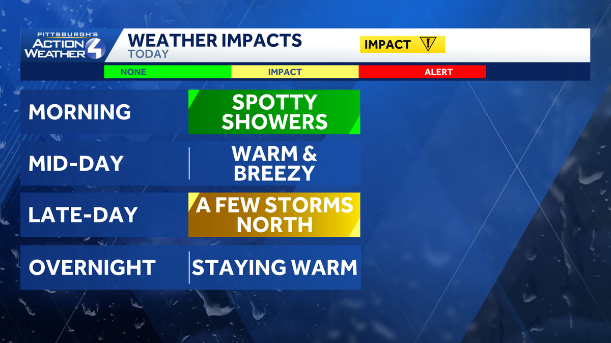
TODAY – Impact Day: Spotty showers with late-day storms north. Breezy and warm. High: 81°.
TONIGHT: Showers and storms fizzle. Staying warm, low: 65°.
WEDNESDAY: Near-record warmth with isolated showers north. High: 84°, low: 66°.
THURSDAY: Scattered rain late. Mostly cloudy and warm. High: 83°, low: 60°.
FRIDAY: Leftover morning showers, then not as warm. High: 79°, low: 58°.