
Pittsburgh area weather turns summer-like with record warmth and storm chances
The best chance for storms will be north of Pittsburgh this evening.
AT KENNYWOOD AVA RASH PITTSBURGH’S ACTION NEWS FOUR SURE SIGN OF SPRING HERE IN WESTERN PENNSYLVANIA WITH KENNYWOOD OPENING, BUT ALSO A FEW MORE CHANCES FOR SHOWERS AND THUNDERSTORMS. WE’RE GOING TO SEE THAT YET AGAIN ON THIS IMPACT DAY. BUT BEFORE WE GET THERE, NOT ONLY FEELING LIKE SUMMER, BUT FEELING OR FEELING LIKE SPRING, BUT MORE LIKE SUMMER, I SHOULD SAY. THIS AFTERNOON COULD CHALLENGE A DAILY RECORD HIGH IN PITTSBURGH, FORECASTING 85. THAT ALSO IS THE RECORD HIGH TODAY, DATING BACK TO 1883. SO A LONG STANDING ONE ON THIS IMPACT DAY. YET AGAIN, THE CORRIDOR FOR STORMS WILL BE PRIMARILY NORTH OF THE CITY OF PITTSBURGH. YOU CAN SEE AN UPGRADE WITH THE SEVERE WEATHER OUTLOOK TODAY. THAT YELLOW AREA INDICATING SCATTERED SEVERE STORMS. THAT’S FROM THE CITY OF PITTSBURGH ON NORTH. I THINK THE CLOSER YOU ARE TO 422 AND I-80, THE BUSIER THAT IT WILL BE. LATE THIS AFTERNOON INTO THE EVENING. STRONG WINDS, LARGE HAIL. OUR PRIMARY CONCERN AS WE GO FORWARD WITH THIS IMPACT DAY. AND YET ANOTHER IMPACT DAY, UNFORTUNATELY COMING IN IN TIME FOR KENNYWOOD’S OPENING DAY ON SATURDAY. BUT IT LOOKS LIKE WE GET THROUGH A GOOD PORTION OF THE DAY RAIN FREE. RIGHT NOW, THINGS ARE A LITTLE BIT BUSIER, CLOSER TO ERIE AS A COMPLEX OF THUNDERSTORMS IS TRYING TO WORK INTO WESTERN NEW YORK. WE’RE GOING TO MISS THOSE STORMS, BUT SOME HEAVIER RAIN NOW COMING OUT OF CRAWFORD COUNTY THAT WILL CLIP AREAS NORTH OF FRANKLIN INTO VENANGO COUNTY AND EVENTUALLY FOREST COUNTY TOO. AS WE WAKE UP THIS MORNING. SO AN IMPACT DAY TODAY, RECORD WARMTH, POSSIBLE FORECASTING 85 ISOLATED STORMS THROUGH THE SECOND HALF OF THE DAY. AGAIN, OUR NEXT IMPACT DAY IS SATURDAY. WE’LL TALK MORE ABOUT THE RAIN TIMING AND EVENTUALLY THE DROP IN TEMPERATURES. IT WILL START TO FEEL A BIT MORE SEASONAL AS WE GET SET FOR THE START OF DRAFT WEEK NEXT WEEK. MAIN CONCERNS YET AGAIN TODAY. DAMAGING WINDS. ALSO SOME LARGE HAIL. FLASH FLOODING. NOT GOING TO BE A HUGE PROBLEM, BUT STILL WE NOTICED YESTERDAY SOME BIG DOWNPOURS COMING IN WITH THOSE STORMS THAT ROCKED THE AREA THROUGH THE START OF THE DAY. THINGS ARE FINE AGAIN. WE’LL KEEP AN EYE ON WHAT’S GOING ON NORTH OF I-80, BUT AS EARLY AS, LET’S SAY SIX, 7:00, WE’LL START TO SEE SOME OF THOSE STORMS FIRING UP. SO THAT’S A LITTLE BIT LATER THAN YESTERDAY. IN THE MEANTIME, PLENTY OF TIME TO WARM THOSE TEMPERATURES UP TO NEAR RECORD LEVELS. A LOT OF THE ACTIVITY ON FUTURECAST HAS BEEN CONSISTENTLY NORTH OF THE CITY, ESPECIALLY NORTH OF 422 AND I-80. BUT THAT’S NOT TO SAY THAT THOSE OF US ACROSS ALLEGHENY COUNTY DON’T GET CLIPPED AS WE WORK THROUGH THE AFTERNOON. MORE PATCHY FOG IS POSSIBLE. HEADING OUT THE DOOR TOMORROW MORNING, WE SHOULD STAY RELATIVELY QUIET THROUGH THE FIRST HALF OF THE DAY, AND THEN WE’LL SEE A LINE OF SHOWERS, POTENTIALLY SOME EMBEDDED THUNDERSTORMS SWINGING IN THROUGH THE AFTERNOON AND EVENING HOURS ON THURSDAY. SO AN IMPACT DAY TODAY. MAIN FOCUS OF THOSE STRONGER STORMS LATER ON THIS AFTERNOON INTO THE EVENING, ESPECIALLY NORTH OF THE CITY. 85. OUR HIGH STILL IN THE 80S. TOMORROW AGAIN THAT RAIN AND STORM CHANCE COMING IN THROUGH THE AFTERNOON AND EVENING. FRIDAY LOOKS TO BE A DELIGHT. MORE SUNSHINE, TEMPERATURES BACKING OFF INTO THE UPPER 70S. THEN ANOTHER IMPACT DAY ON SATURDAY. QUIET AND DRY THROUGH THE MORNING. EARLY AFTERNOON. BUT AS WE GET INTO THE EVENING, CERTAINLY THE OVERNIGHT HOURS, WE’LL SEE MORE RAIN. RAINDROPS SHOULD BE CLEARING OUT QUICKLY EARLY ON WEDNESDAY SUNDAY, EXCUSE ME, BUT TEMPERATURES ARE GOING TO BE DROPPING. WE GO FROM THE LOW 80S TO JUST THE LOW 60S ON SUNDAY. WE WILL KEEP IT ON THE COOL SIDE EARLY NEXT WEEK. ANOTHER REMINDER STILL TOO EARLY TO PLANT. CHECK OUT THOSE LOW TEMPERATURES, ESPECIALLY MONDAY AND TUESDAY CLOSER TO THE FREEZING MARK. SO I KNOW EVERYBODY’S GETTING EXCITED TO GET THE YARD THE GARDEN, READY TO GO FOR SPRING, BUT STILL TOO EARLY JUST YET. AS WE’RE HOLDING ON TO THESE 80S FOREVER, AT LEAST AT THIS POINT. I’M GLAD YOU MENTIONED THAT BECAUSE I THINK THAT’S ON THE MINDS FOR A LOT OF PEOPLE WHEN THEY SEE THOSE TEMPS. I HAVE A COUPLE PLANTS ON MY
Pittsburgh area weather turns summer-like with record warmth and storm chances
The best chance for storms will be north of Pittsburgh this evening.

Updated: 6:46 AM EDT Apr 15, 2026
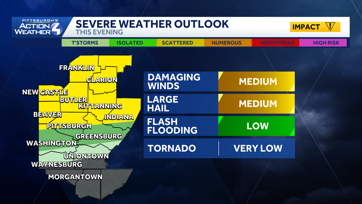
Wednesday is another Impact Day with all of the makings of a summer day for western Pennsylvania. We are tracking record warmth along with late-day storm chances with similar coverage and timing to yesterday’s round. Our run of unseasonably warm and unsettled days extends through Saturday.Impact Day: Record warmth and storm chancesPittsburgh has already set a number of warm morning records this week. We look to tie a long-standing record this afternoon. Temperatures will soar into the mid 80s – which is more typical for the height of summer. The record is 85° from 1883.The summertime feeling will lead to another round of storms, especially north of Pittsburgh. Isolated to scattered thunderstorms are possible. Damaging winds, large hail and downpours are expected again. The onset could be a few hours later this yesterday, closer to dinnertime and sunset.Another Impact Day SaturdayA few more showers and storms will bubble up late Thursday. We will take a break from the daily shower and storm threat plus ease the unseasonable warmth on Friday. The work week should end on a really nice note.Saturday is now an Impact Day. Area-wide rain with embedded storms will arrive during the afternoon or evening. The exact timing will come into better view in the coming days. Showers will wrap up early Sunday morning with dropping temperatures. Instead of highs in the 80s, Sunday will trend much cooler but more seasonal with a high in the lower 60s.Dry and seasonal start to next weekIt’s not time to plant yet. The dose of cooler air will push lows into frosty and freezing territory early next week. Dry conditions will last through Wednesday with highs creeping toward 70 degrees.TODAY – Impact Day: Record warmth, mostly cloudy and breezy. Late-day spotty strong storms, especially north of Pittsburgh. High: 85°.TONIGHT: Scattered rain and storms to the north. Mostly cloudy with patchy fog. Low: 66°.THURSDAY: Afternoon shower or storm. Still warm. High: 82°, low: 60°.FRIDAY: Nice with mostly sunny skies. High: 78°, low: 58°.SATURDAY – Impact Day: Summer-like again. Rain returns during the afternoon and evening. High: 83°, low: 48°.
Wednesday is another Impact Day with all of the makings of a summer day for western Pennsylvania.
We are tracking record warmth along with late-day storm chances with similar coverage and timing to yesterday’s round. Our run of unseasonably warm and unsettled days extends through Saturday.
Impact Day: Record warmth and storm chances
Pittsburgh has already set a number of warm morning records this week. We look to tie a long-standing record this afternoon. Temperatures will soar into the mid 80s – which is more typical for the height of summer. The record is 85° from 1883.

The summertime feeling will lead to another round of storms, especially north of Pittsburgh. Isolated to scattered thunderstorms are possible. Damaging winds, large hail and downpours are expected again. The onset could be a few hours later this yesterday, closer to dinnertime and sunset.

Another Impact Day Saturday
A few more showers and storms will bubble up late Thursday. We will take a break from the daily shower and storm threat plus ease the unseasonable warmth on Friday. The work week should end on a really nice note.

Saturday is now an Impact Day. Area-wide rain with embedded storms will arrive during the afternoon or evening. The exact timing will come into better view in the coming days. Showers will wrap up early Sunday morning with dropping temperatures. Instead of highs in the 80s, Sunday will trend much cooler but more seasonal with a high in the lower 60s.
Dry and seasonal start to next week
It’s not time to plant yet. The dose of cooler air will push lows into frosty and freezing territory early next week. Dry conditions will last through Wednesday with highs creeping toward 70 degrees.

TODAY – Impact Day: Record warmth, mostly cloudy and breezy. Late-day spotty strong storms, especially north of Pittsburgh. High: 85°.
TONIGHT: Scattered rain and storms to the north. Mostly cloudy with patchy fog. Low: 66°.
THURSDAY: Afternoon shower or storm. Still warm. High: 82°, low: 60°.
FRIDAY: Nice with mostly sunny skies. High: 78°, low: 58°.
SATURDAY – Impact Day: Summer-like again. Rain returns during the afternoon and evening. High: 83°, low: 48°.