
Impact Day: Record heat, more storms north of Pittsburgh
The best chance for storms will be north of Pittsburgh this evening.
KENNYWOOD AVA RASH. PITTSBURGH’S ACTION NEWS FOUR. KENNYWOOD OPENINGS ARE GETTING US READY FOR SUMMER AND SO WILL THE FORECAST TODAY ON THE SECOND IMPACT DAY IN A ROW. NO PROBLEMS GETTING OUT THE DOOR THROUGH THE AFTERNOON. WE’LL TRACK THOSE TEMPERATURES. THAT COULD TIE A RECORD HERE IN PITTSBURGH, BUT THEN IT’S THROUGH THE EVENING HOURS, MAYBE A LITTLE BIT LATER THAN WHAT WE DEALT WITH YESTERDAY. FOR MORE SCATTERED STORMS, MAIN FOCUS WILL BE NORTH OF THE CITY AND EVEN STILL THROUGH THE FIRST PART OF THE NIGHT, WE COULD SEE A LITTLE BIT OF ACTION CLOSER TO I-80, SOME VERY LOCALIZED SHOWERS OUT THERE RIGHT NOW, A FRESH LITTLE SHOWER POPPING UP RIGHT NOW NEAR THE I 79 279 SPLIT. ALSO GETTING CLOSER TO THE ALLEGHENY VALLEY INTERCHANGE ALONG THE TURNPIKE. MOST OF THE ACTION THOUGH, EXITING ARMSTRONG CLARION COUNTIES HEADING OVER TOWARDS INDIANA AT THIS POINT. THAT WAS. WITH A FADING BATCH OF THUNDERSTORMS THAT CUT ACROSS LAKE ERIE. WE’RE GOING TO SEE MORE POPPING UP TO OUR NORTH AS WE GO THROUGH THE AFTERNOON. HERE’S YOUR FOUR DAY FORECAST. GET AN IMPACT DAY TODAY AS WE’LL SEE THOSE ISOLATED, STRONGER THUNDERSTORMS, ESPECIALLY NORTH OF TOWN. WHILE WE WAIT, WE’RE BUILDING UP A LOT OF HEAT, ESPECIALLY FOR THIS TIME OF THE YEAR, CHALLENGING A RECORD HIGH HERE IN PITTSBURGH, FORECASTING 85 THAT WOULD TIE THE RECORD FROM 1883. BREEZY, WARM, BRINGING ALL THE SUMMER VIBES FOR US TODAY. STILL NOT DONE WITH THE UNSETTLED SUMMER LIKE CONDITIONS. ONE MORE GO AROUND TOMORROW. FRIDAY LOOKS TO BE A DANDY WITH MORE SUNSHINE. 78 AND THEN ANOTHER NEW IMPACT DAY ON SATURDAY WILL NOT BE A WASHOUT FOR KENNYWOOD’S OPENING DAY, BUT WE WILL BE MONITORING RAIN CHANCES AND BIGGER CHANGES AS WE GO THROUGH THE WEEKEND. STORM THREATS TODAY, DAMAGING WINDS, LARGE HAIL VERY SIMILAR TO YESTERDAY WILL LEAD THE WAY. FLASH FLOODING RISK IS LOW, BUT THERE WILL BE SOME BIG GUSHES OF RAIN THAT COME WITH THOSE STRONGER THUNDERSTORMS THAT WILL BE WIDELY SCATTERED ACROSS THE REGION AS WE GO THROUGH THE AFTERNOON AND EVENING AGAIN, PLENTY OF TIME FOR THE ATMOSPHERE TO GET SET FOR THOSE STORMS, AS TEMPERATURES WILL CLIMB WELL INTO THE 80S FOR US THIS AFTERNOON. STARTING POINT OF SOME OF THESE STORMS, MORE THAN LIKELY CLOSER TO DINNER TIME, POSSIBLY EVEN SUNSET FUTURE CAST KEEPING A LOT OF THAT ACTION NORTH OF 422 UP ALONG I-80. BUT I THINK ANYBODY NORTH OF I-70, YOU COULD CATCH ONE OF THOSE STRAY STORMS AS WE GO THROUGH THE EVENING HOURS, EVERYTHING WILL CALM DOWN AFTER MIDNIGHT. WATCH OUT FOR SOME AREAS OF FOG TOMORROW MORNING. ANOTHER MUGGY START AND THEN HERE WE GO AGAIN THROUGH THE AFTERNOON. TOMORROW A LINE OF SHOWERS AND DOWNPOURS. THUNDERSTORMS WILL BE POSSIBLE. NOT EXPECTING QUITE AS MUCH IN THE WAY OF STRONG TO SEVERE STORMS THURSDAY AFTERNOON. THAT, PLUS THE UNSETTLED WEATHER TO REST AT LEAST FOR A DAY. THEN, AS WE LOOK AHEAD TO SATURDAY, WE START OFF THE MORNING DRY. IT’S THROUGH THE LATE AFTERNOON EVENING HOURS. WE’LL SEE THAT PUSH OF RAIN. ALSO A BIG DROP IN TEMPERATURE. ONE MORE DAY IN THE 80S. CAN’T SAY THE SAME FOR SUNDAY THOUGH. TEMPERATURES COOLING OFF INTO THE LOWER 60S. A REMINDER THROUGHOUT THIS WEEKEND. DON’T PLAN ANYTHING QUITE JUST YET. SOME FROST
Impact Day: Record heat, more storms north of Pittsburgh
The best chance for storms will be north of Pittsburgh this evening.

Updated: 7:02 AM EDT Apr 15, 2026
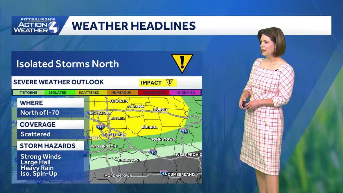
Today is another Impact Day with all of the makings of a summer day for western Pennsylvania. We are tracking record warmth along with late-day storm chances with similar coverage and timing to yesterday’s round. Our run of unseasonably warm and unsettled days extends through Saturday.Impact Day: Record warmth and storm chancesPittsburgh has already set a number of warm morning records this week. We look to tie a long-standing record this afternoon. Temperatures will soar into the mid 80s – which is more typical for the height of summer. The record is 85° from 1883.The summertime feeling will lead to another round of storms, especially north of Pittsburgh. Isolated to scattered thunderstorms are possible. Damaging winds, large hail and downpours are expected again. The onset could be a few hours later this yesterday, closer to dinnertime and sunset.Another Impact Day SaturdayA few more showers and storms will bubble up late Thursday. We will take a break from the daily shower and storm threat plus ease the unseasonable warmth on Friday. The work week should end on a really nice note.Saturday is now an Impact Day. Area-wide rain with embedded storms will arrive during the afternoon or evening. The exact timing will come into better view in the coming days. Showers will wrap up early Sunday morning with dropping temperatures. Instead of highs in the 80s, Sunday will trend much cooler but more seasonal with a high in the lower 60s.Dry and seasonal start to next weekIt’s not time to plant yet. The dose of cooler air will push lows into frosty and freezing territory early next week. Dry conditions will last through Wednesday with highs creeping toward 70 degrees.TODAY – Impact Day: Record warmth, mostly cloudy and breezy. Late-day spotty strong storms, especially north of Pittsburgh. High: 85°.TONIGHT: Scattered rain and storms to the north. Mostly cloudy with patchy fog. Low: 66°.THURSDAY: Afternoon shower or storm. Still warm. High: 82°, low: 60°.FRIDAY: Nice with mostly sunny skies. High: 78°, low: 58°.SATURDAY – Impact Day: Summer-like again. Rain returns during the afternoon and evening. High: 83°, low: 48°.
PITTSBURGH —
Today is another Impact Day with all of the makings of a summer day for western Pennsylvania. We are tracking record warmth along with late-day storm chances with similar coverage and timing to yesterday’s round. Our run of unseasonably warm and unsettled days extends through Saturday.
Impact Day: Record warmth and storm chances
Pittsburgh has already set a number of warm morning records this week. We look to tie a long-standing record this afternoon. Temperatures will soar into the mid 80s – which is more typical for the height of summer. The record is 85° from 1883.

The summertime feeling will lead to another round of storms, especially north of Pittsburgh. Isolated to scattered thunderstorms are possible. Damaging winds, large hail and downpours are expected again. The onset could be a few hours later this yesterday, closer to dinnertime and sunset.

Another Impact Day Saturday
A few more showers and storms will bubble up late Thursday. We will take a break from the daily shower and storm threat plus ease the unseasonable warmth on Friday. The work week should end on a really nice note.

Saturday is now an Impact Day. Area-wide rain with embedded storms will arrive during the afternoon or evening. The exact timing will come into better view in the coming days. Showers will wrap up early Sunday morning with dropping temperatures. Instead of highs in the 80s, Sunday will trend much cooler but more seasonal with a high in the lower 60s.
Dry and seasonal start to next week
It’s not time to plant yet. The dose of cooler air will push lows into frosty and freezing territory early next week. Dry conditions will last through Wednesday with highs creeping toward 70 degrees.

TODAY – Impact Day: Record warmth, mostly cloudy and breezy. Late-day spotty strong storms, especially north of Pittsburgh. High: 85°.
TONIGHT: Scattered rain and storms to the north. Mostly cloudy with patchy fog. Low: 66°.
THURSDAY: Afternoon shower or storm. Still warm. High: 82°, low: 60°.
FRIDAY: Nice with mostly sunny skies. High: 78°, low: 58°.
SATURDAY – Impact Day: Summer-like again. Rain returns during the afternoon and evening. High: 83°, low: 48°.