
Today’s high of 87 degrees will tie the record, set in 1941. Expect morning clouds, then clearing. We’ll see partly to mostly sunny skies this afternoon and higher dew points, in the low 60s, making it feel sticky for April. Isolated evening thunderstorms are possible in northern counties, but most of the area will stay dry. Expect a 5-15 mph west-southwesterly breeze. Tonight, lows will fall to 64 degrees under partly cloudy skies. The record warmest low is 63, set in 1941. Thursday will be equally warm. Highs will soar to the mid-to-upper 80s, and humidity levels will still be a bit sticky. Ahead of a cold front, scattered showers and a few thunderstorms are possible Thursday evening into Thursday night. At this time, we are not outlooked for any severe storms.Friday will feature partly sunny skies and slightly cooler highs near 80. However, that’s still 15 degrees above average! After one more day in the low 80s Saturday, our summer stretch will come to an end. Expect a cold front to bring showers Saturday night into the first half of Sunday and cooler, more seasonable highs near 60 degrees.Monday will be the coolest day next week, around 56 degrees. Monday night will be cold! Expect lows in the low-to-mid 30s with a brisk breeze. Tuesday will also be cool, with highs near 60 and a light breeze. If you’re looking for more seasonable temperatures, highs will be a few degrees above average, near 70 Wednesday through Friday with a slim chance of showers.
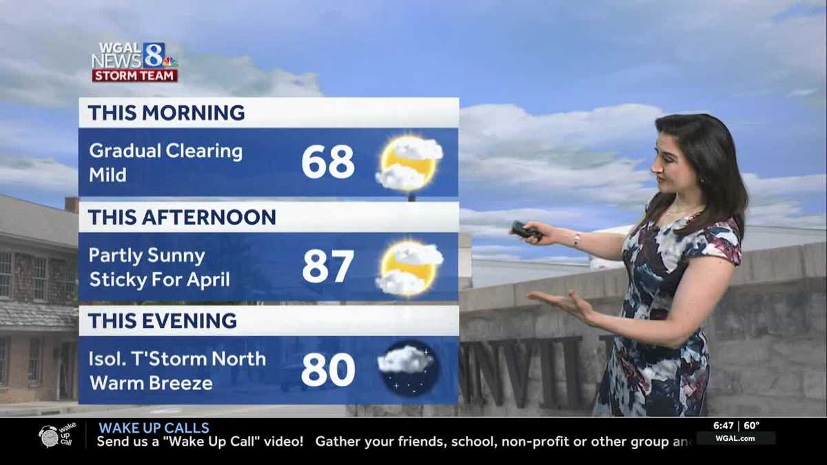
Today’s high of 87 degrees will tie the record, set in 1941. Expect morning clouds, then clearing. We’ll see partly to mostly sunny skies this afternoon and higher dew points, in the low 60s, making it feel sticky for April. Isolated evening thunderstorms are possible in northern counties, but most of the area will stay dry. Expect a 5-15 mph west-southwesterly breeze.
Tonight, lows will fall to 64 degrees under partly cloudy skies. The record warmest low is 63, set in 1941.
Thursday will be equally warm. Highs will soar to the mid-to-upper 80s, and humidity levels will still be a bit sticky. Ahead of a cold front, scattered showers and a few thunderstorms are possible Thursday evening into Thursday night. At this time, we are not outlooked for any severe storms.
Friday will feature partly sunny skies and slightly cooler highs near 80. However, that’s still 15 degrees above average!
After one more day in the low 80s Saturday, our summer stretch will come to an end. Expect a cold front to bring showers Saturday night into the first half of Sunday and cooler, more seasonable highs near 60 degrees.
Monday will be the coolest day next week, around 56 degrees. Monday night will be cold! Expect lows in the low-to-mid 30s with a brisk breeze.
Tuesday will also be cool, with highs near 60 and a light breeze. If you’re looking for more seasonable temperatures, highs will be a few degrees above average, near 70 Wednesday through Friday with a slim chance of showers.