
After tying the record high of 87 degrees yesterday, we’ll challenge another record high today! The record stands at 89, set in 2002. Under partly to mostly sunny skies, highs will soar to the upper 80s this afternoon and humidity levels will be a bit sticky. Expect a light breeze out of the west-southwest. Ahead of a cold front, isolated showers and thunderstorms are possible late this evening into early tonight. We are not outlooked for severe weather, and most spots will stay dry. Overnight, clouds will partially clear, and temperatures will stay well above average, around 64 degrees. The record warmest low is 60, set in 2002. Friday will feature partly sunny skies and cooler highs near 78. However, that’s still nearly 15 degrees above average!After one more day in the low 80s on Saturday, our summer stretch will come to an end. Expect a cold front to bring showers Saturday evening into Sunday morning. Cooler highs in the upper 50s are in store Sunday. Monday will be the coolest day next week, around 54 degrees. Monday night will be cold! Expect lows in the low-to-mid 30s with a brisk breeze.Tuesday will be milder, with highs near 60 and a light breeze. If you’re looking for warmer temperatures, highs will be a few degrees above average, near 70, Wednesday through Friday, with a slim chance of showers Wednesday, and again Friday.
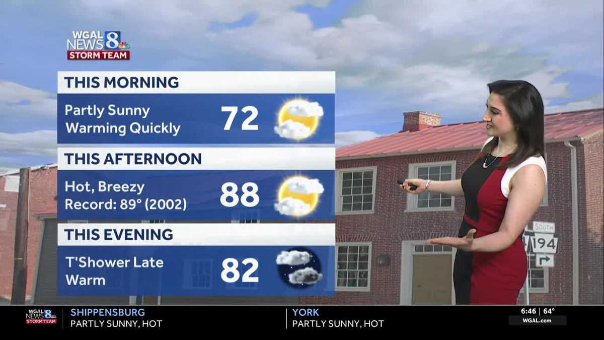
After tying the record high of 87 degrees yesterday, we’ll challenge another record high today! The record stands at 89, set in 2002.
Under partly to mostly sunny skies, highs will soar to the upper 80s this afternoon and humidity levels will be a bit sticky. Expect a light breeze out of the west-southwest.
Ahead of a cold front, isolated showers and thunderstorms are possible late this evening into early tonight. We are not outlooked for severe weather, and most spots will stay dry.
Overnight, clouds will partially clear, and temperatures will stay well above average, around 64 degrees. The record warmest low is 60, set in 2002.
Friday will feature partly sunny skies and cooler highs near 78. However, that’s still nearly 15 degrees above average!
After one more day in the low 80s on Saturday, our summer stretch will come to an end. Expect a cold front to bring showers Saturday evening into Sunday morning. Cooler highs in the upper 50s are in store Sunday.
Monday will be the coolest day next week, around 54 degrees. Monday night will be cold! Expect lows in the low-to-mid 30s with a brisk breeze.
Tuesday will be milder, with highs near 60 and a light breeze. If you’re looking for warmer temperatures, highs will be a few degrees above average, near 70, Wednesday through Friday, with a slim chance of showers Wednesday, and again Friday.