
Chillier & breezy this evening; Freeze Watch for Tuesday AM across south-central Pennsylvania
Unseasonably cool conditions settling in the area, which is also prompting a Freeze Watch for Monday night through Tuesday morning. 70s are back in the forecast for late this week!
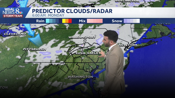
DRONE SHIP JACQUELINE IN THE ATLANTIC OCEAN. RYAN, WE’RE LOOKING AT THAT WEATHER. WE HAD A GORGEOUS RAINBOW. IT’S DISAPPEARING RIGHT BEHIND YOU. BUT TELL US ABOUT IT. YEAH, I WAS JUST ABOUT TO. I WAS REALLY HOPING THIS RAINBOW WAS GOING TO LAST FOR EVERYBODY. BUT WE HAD A BEAUTIFUL RAINBOW. JUST. IT WAS IT WAS IT WAS BOWING OUT. IT WAS IT WAS BRIGHT. IT WAS VERY VIBRANT. IF YOU’RE TUNING IN FROM LANCASTER RIGHT NOW, THIS IS THE LANCASTER SKY CAM. SO IF YOU’VE BEEN OUTSIDE TODAY OR IF YOU’RE OUT IN LANCASTER RIGHT NOW, YOU’RE PROBABLY THIS WAY. YOU’RE PROBABLY LOOKING AT THE RAINBOW THAT IS NOW STARTING TO DISSIPATE. BUT WE’VE HAD A BIT OF A BRIGHT AFTERNOON SO FAR, A MIX OF SOME SUN AND SOME CLOUDS. ALSO SOME STRAY SHOWERS THAT ARE MOVING THROUGH THE AREA. AT THIS TIME, TEMPERATURES ARE INTO THE LOWER 50S, BUT COOLER AIR HAS ARRIVED. WE HAD A COLD FRONT MOVED THROUGH EARLIER THIS MORNING. THAT’S TRIGGERED SOME SHOWERS EARLY THIS MORNING WITH HIGHS INTO THE 40S AND 50S. THEN A FREEZE WATCH IS INBOUND AS WE HEAD INTO MONDAY NIGHT INTO TUESDAY MORNING, TEMPERATURES ARE GOING TO TAKE A DIVE TO THE 30S, WHERE THE LOW 30S EVEN INTO THE UPPER 20S FOR MOST OF THE AREA. AND THEN AS WE HEAD INTO LATER THIS WEEK, WE ARE GOING TO BE SEEING THAT WARM UP WE’RE CHATTING ABOUT SEEING THOSE 70S ONCE AGAIN, AND WE WILL BE SEEING THOSE AS ONCE WE GET TO CLOSER TO THURSDAY AND FRIDAY OF THIS COMING WEEK. SO CLEARING SKIES FOR THE REST OF THIS EVENING, 48 DEGREES DROPPING DOWN TO THE UPPER 30S FOR TONIGHT. STILL LOOKING AT THE CHANCE OF SOME ISOLATED SHOWERS. BUT BECAUSE OF HOW ISOLATED AND STRAY THEY ARE IN NATURE, I REALLY THINK THAT THE MAJORITY OF THE NIGHT’S GOING TO BE REMAINING DRY. SO JUST REALLY LEFT THAT THE PARTLY CLOUDY ICON THERE. THEN SUN AND CLOUDS FOR TOMORROW. BREEZY AND COOLER ONCE AGAIN, 48 DEGREES FOR TOMORROW AFTERNOON. SO A BIT CHILLY AS WE HEAD INTO OUR MONDAY. AND IF YOU ARE GOING TO BE SPENDING SOME TIME IN THE HERSHEY GARDENS AGAIN, TULIPS IN PEAK BLOOM. IT WILL BE OPEN DAILY FROM 9 TO 5, SO WE’RE COOLER THAN AVERAGE AS WE HEAD INTO THE NEXT FEW DAYS. BUT AS WE HEAD INTO WEDNESDAY, LOOK AT THAT 66 DEGREES FEELING WARMER OUT THERE WITH HIGHER TEMPERATURES INTO THE MID 60S. POLLEN LEVELS THOUGH FOR TOMORROW THEY’RE GOING TO BE VERY HIGH AS WE HEAD INTO THE AFTERNOON. LOW MOLD LEVELS AIR QUALITY IS GOOD. MODERATE UV INDEX GOT ABOUT A 40 MINUTE BURN TIME FOR THE AFTERNOON TEMPERATURES INTO THE 50S. YOU CAN SEE 54 IN HARRISBURG, 50 IN LEWISTOWN, 57 THOUGH IN CHAMBERSBURG AND 61 DEGREES IN GETTYSBURG. AT THIS HOUR. IT’S VERY BREEZY, THOUGH. THAT’S ANOTHER PART OF THIS AFTERNOON. THE STORY OF THIS AFTERNOON IS THAT IT’S BEEN. IT’S BEEN QUITE A BREEZY DAY. YOU SEE WIND SPEEDS BETWEEN 15 AND 25MPH, GENERALLY ACROSS THE AREA. SO GOOD TO BE SEEING THOSE WINDS SLOWLY DIMINISH THOUGH, ONCE WE GET INTO LATE IN THE EVENING. SO STORM TEAM, LIVE RADAR NETWORK JUST SEEING SOME ISOLATED SHOWERS ACROSS THE AREA. BUT MOST SPOTS YOU CAN SEE MOST AREAS ARE STAYING DRY. JUST YOU MAY SEE A SPRINKLE OR TWO AS THIS. AS WE STILL SEE THE EFFECTS OF THAT COLD FRONT. AS YOU CAN SEE, MOVING OUT TO SEA OR HAS ALREADY MOVED OUT TO SEA. BUT THEN THERE’S ANOTHER COLD FRONT THAT’S GOING TO PUSH THROUGH. THAT’S GOING TO GO THROUGH OVERNIGHT TONIGHT. THAT’S GOING TO CONTINUE TO DROP OUR TEMPERATURES. SO 6 A.M. MONDAY, IN THE WAKE OF THAT FRONT, YOU SEE THERE’S MAINLY CLEAR CONDITIONS. AND THEN WE’LL SEE PARTLY SUNNY CONDITIONS AS WE HEAD INTO THE AFTERNOON AND EVENING. HIGH PRESSURE SETTLES IN. STILL HELPS TO USHER IN COOLER AIR FROM THE SOUTH. BUT THAT’S GOING TO HELP RELAX OUR WINDS AS WE GET INTO TUESDAY MORNING AND ALSO HEADING INTO THE AFTERNOON. BUT MILDER AIR DOES START TO SURGE IN AS HIGH PRESSURE SHIFTS OFFSHORE. THAT’S WHAT’S GOING TO BE ALLOWING TEMPERATURES TO REBOUND TO THE MID 60S. BUT LOOK AT THIS THOUGH AS WE HEAD INTO OVERNIGHT MONDAY INTO TUESDAY. I WANTED TO MAKE THIS AS A NOTE. WE DO HAVE AN IMPACT NIGHT SET FOR MONDAY NIGHT INTO TUESDAY MORNING. AND THIS IS WHY LOOK AT THE POTENTIAL TEMPERATURES AS WE GET INTO MONDAY NIGHT INTO EARLY TUESDAY MORNING. TEMPERATURES GETTING INTO THE UPPER 20S INTO THE LOWER 30S. AND SO WE DO HAVE A FREEZE WATCH THAT’S GOING TO BE GOING INTO EFFECT FROM 12 A.M. TUESDAY TO 9 A.M. TUESDAY, OR JUST FOR MONDAY NIGHT. SO BY THE TIME WHEN WE GET TO MONDAY NIGHT, MAKE SURE THAT YOU COVER ANY SENSITIVE PLANTS, CROPS AND VEGETATION, ANY POTTED PLANTS THAT YOU MIGHT HAVE OUT, BACK OR OUT FRONT SITTING ON YOUR PORCH, YOU WANT TO MAKE SURE YOU BRING THOSE INSIDE. IT’S GOING TO BE GETTING VERY COLD. AS YOU CAN SEE, TEMPERATURES GETTING INTO THE LOWER 30S. AS YOU CAN SEE FOR MONDAY NIGHT. NOW LOOK AT THIS THOUGH GETTING INTO THE REST OF THE WEEK. WE’RE GETTING INTO THE 70S FOR THURSDAY AND FRIDAY AND A BIT OF
Chillier & breezy this evening; Freeze Watch for Tuesday AM across south-central Pennsylvania
Unseasonably cool conditions settling in the area, which is also prompting a Freeze Watch for Monday night through Tuesday morning. 70s are back in the forecast for late this week!

Updated: 5:37 PM EDT Apr 19, 2026
In the wake of a cold frontal passage this morning, skies have brightened with breaks of sunshine. Some areas are seeing a stray shower passing through, but most spots will remain dry this evening. Expect winds to diminish through the evening out of the northwest between 5 to 15 mph with temperatures falling to the upper 40s.Tonight, after clearing through the evening, some clouds return, as a disturbance moves through after midnight. A few sprinkles can’t be ruled out. Low temperatures are chilly in the upper 30s.Monday will be the coolest day, in the upper 40s, under a mix of clouds and sunshine. High pressure building overhead brings calm, clear conditions Monday night resulting in temperatures dropping to around freezing Tuesday morning. With the growing season already started, a Freeze Watch has been issued by the National Weather starting at 12 am Tuesday through 9 am Tuesday for the entire Susquehanna Valley. Don’t forget to protect tender plants and vegetation!Tuesday will still be unseasonably cool in the mid to upper 50s with a light breeze. If you’re looking for warmer temperatures, highs will be near 70 on Wednesday with a chance of morning showers. It’s even warmer Thursday and Friday in the mid to upper 70s.Another chance of showers arrives Saturday into Sunday. Highs in the 70s drop to more seasonable temperatures in the mid 60s on Sunday.Have a great rest of your Sunday!~ Ryan
In the wake of a cold frontal passage this morning, skies have brightened with breaks of sunshine. Some areas are seeing a stray shower passing through, but most spots will remain dry this evening. Expect winds to diminish through the evening out of the northwest between 5 to 15 mph with temperatures falling to the upper 40s.
Tonight, after clearing through the evening, some clouds return, as a disturbance moves through after midnight. A few sprinkles can’t be ruled out. Low temperatures are chilly in the upper 30s.
Monday will be the coolest day, in the upper 40s, under a mix of clouds and sunshine. High pressure building overhead brings calm, clear conditions Monday night resulting in temperatures dropping to around freezing Tuesday morning. With the growing season already started, a Freeze Watch has been issued by the National Weather starting at 12 am Tuesday through 9 am Tuesday for the entire Susquehanna Valley. Don’t forget to protect tender plants and vegetation!
Tuesday will still be unseasonably cool in the mid to upper 50s with a light breeze. If you’re looking for warmer temperatures, highs will be near 70 on Wednesday with a chance of morning showers. It’s even warmer Thursday and Friday in the mid to upper 70s.
Another chance of showers arrives Saturday into Sunday. Highs in the 70s drop to more seasonable temperatures in the mid 60s on Sunday.
Have a great rest of your Sunday!
~ Ryan