
Breezy & chilly Monday, Freeze Watch for Tuesday AM across south-central Pennsylvania
Unseasonably cool conditions have settled in over the area, which is also prompting a Freeze Watch for Monday night through Tuesday morning. 70s are back in the forecast for late this week!
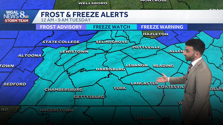
NOW THE WGAL NEWS EIGHT STORM TEAM FORECAST WITH METEOROLOGIST RYAN ARGENTINA TRACKING LOWER TEMPERATURES AS WE HEAD INTO THE BEGINNING OF THE WORKWEEK. SO, SO LOW THAT WE ACTUALLY HAVE A FREEZE WATCH THAT WILL BE GOING INTO EFFECT MONDAY NIGHT. SO YOU’RE GOING TO WANT TO MAKE SURE THAT YOU COVER YOUR SENSITIVE PLANTS AS WE HEAD INTO THE OVERNIGHT PERIOD TOMORROW. LATER IN THE WEEK, WE DO RETURN TO THE 70S. SO THOSE OF YOU WHO ARE HOPING FOR THAT WARMER WEATHER, IT IS GOING TO BE COMING BACK. AND THEN FOR THE WEEKEND, WE DO HAVE SOME MORE RAIN CHANCES, BUT IT IS A BIT OF AN UNSETTLED PATTERN. SO THAT’S WHY WE HAVE THOSE RAIN CHANCES THERE TO BEGIN WITH. BUT WE HIT RIGHT AROUND 58 DEGREES. THAT’S WHAT WE THAT WAS THE HIGH FOR THIS AFTERNOON. 65 IS WHAT WE EXPECT FOR THIS TIME OF YEAR. AND WE’RE RIGHT AROUND PAR IN TERMS OF OVERNIGHT LOWS AT JUST OVER 3/10 OF AN INCH OF SOME RAIN RECORDED AT HARRISBURG INTERNATIONAL AIRPORT. SO WE’LL CONTINUE TO SEE PARTLY CLOUDY CONDITIONS WITH A CHANCE OF SOME ISOLATED SHOWERS. BUT THE CHANCE IS SO ISOLATED. I REALLY THINK THAT THE REST OF THE NIGHT’S GOING TO BE REMAINING DRY, BUT WE WILL START WILL START TO GO DOWN TO THE UPPER 30S FOR TONIGHT, THEN PARTLY SUNNY FOR TOMORROW MORNING. INCREASING WINDS WILL BE RIGHT AROUND 42 DEGREES, THEN 48 FOR TOMORROW AFTERNOON WITH A MIX OF SOME CLOUDS AND SUN. AND IT WILL BE A BREEZY AND COOLER ONCE AGAIN. NOW TREE POLLEN LEVELS THAT’S THEY’RE GOING TO BE VERY HIGH. THEY’RE GOING TO CONTINUE TO STAY HIGH FOR THESE NEXT SEVERAL DAYS. AND FOR THE MOLD LEVELS ARE LOW. AIR QUALITY IS GOOD. AND WE HAVE ABOUT A 40 MINUTE BURN TIME. SO WE HAVE THAT RATED AS A MODERATE UV INDEX. BUT THE NEXT BEST CHANCE OF SHOWERS FOR TOMORROW AND TUESDAY. LOOKING LIKE A VERY DRY DAY. IT’S WHEN WE GET INTO EARLY WEDNESDAY, THAT’S WHEN WE’RE GOING TO BE LOOKING AT THE NEXT CHANCE OF SOME SHOWERS THURSDAY. NOT LOOKING AT ANY OTHER CHANCES. NOW WE’RE 48 IN HARRISBURG, 46 IN CARLISLE, 41 IN LEWISTOWN. AND WE’RE INTO THE LOOK AT THAT UPPER UPPER 30S FOR YORK AT THIS TIME. AND WE’RE 43 IN THE RED ROSE CITY. SO EARLIER THIS EVENING HAD SOME HAD SOME ISOLATED SHOWERS PUSHING THROUGH THE PUSHING THROUGH THE AREA. BUT MOST OF THE AREAS LOOKING DRY RIGHT NOW, NOT REALLY SEEING ANY IMPACTFUL SHOWERS OTHER THAN SOME OF THESE SHOWERS. AND LOOK AT THIS. A LITTLE BIT OF SOME SNOW IN THE UPPER LEVELS OF THE ATMOSPHERE IS GETTING PICKED UP BY THE RADAR, BUT THAT’S OUT OF OUR VIEWING AREA. NOW WE DO HAVE ANOTHER COLD FRONT THAT’S GOING TO PUSH THROUGH. THAT’S WHAT’S GOING TO ALLOW OR POSSIBLY ALLOW THAT ISOLATED SHOWER CHANCE OVERNIGHT TONIGHT. BUT ONCE THAT COLD FRONT PUSHES THROUGH, WE’LL SEE IN THE WAKE OF THAT FRONT, SOME DRIER AIR WILL STILL SEE THAT WILL WILL HAVE HIGH PRESSURE USHERING IN THAT COOLER AIR FROM THE NORTH. BUT THAT THAT AS SOON AS THAT CENTER OF HIGH PRESSURE STARTS TO SIT OVERHEAD, THAT’S WHAT’S GOING TO HELP TO RELAX OUR WINDS. BUT IT’S GOING TO BE KEEPING OUR SKIES CLEAR ONCE WE GET INTO OUR TUESDAY, WE’LL STILL SEE SOME MORE CLOUDS AS WE STILL HAVE A SERIES OF SOME FRONTS THEY’RE GOING TO PASS BY OR NEAR BY THE COMMONWEALTH. NOW THIS IS WHAT I WANT TO SHOW YOU AS WE AS WE GET INTO MONDAY NIGHT INTO EARLY TUESDAY MORNING, TEMPERATURES COULD BE GETTING INTO THE LOWER 30S AND MOST OF THE AREA. LOOK AT THIS. COULD BE GETTING INTO THE MID TO UPPER 20S. AND THAT’S GOING TO BE WHERE THAT’S BELOW FREEZING FOLKS. SO WE DO HAVE A FREEZE WATCH THAT’S GOING TO BE GOING INTO EFFECT FROM 12 A.M. TUESDAY TILL 9 A.M. TUESDAY. THAT’S FOR THE ENTIRE SUSQUEHANNA VALLEY YOU CAN SEE OUTSIDE OF OUR VIEWING AREA, ESPECIALLY TOWARDS STATE COLLEGE, THERE IS A FREEZE WARNING. SO SOMETHING THAT WE’RE GOING TO CONTINUE TO WATCH, BUT WE DO HAVE THAT SET AS AN IMPACT NIGHT MONDAY NIGHT THAT IS INTO EARLY TUESDAY MORNING. WE HAVE IT AS AN IMPACT NIGHT FOR THOSE LOWS. GETTING INTO THE UPPER 20S. SO THE WAY YOU SHOULD PREPARE, MAKE SURE YOU COVER ANY SENSITIVE PLANTS. IF YOU HAVE ANY PLANTS OUTDOORS THAT YOU WANT TO MAKE SURE YOU BRING INSIDE. IF THEY’RE POTTED, MAKE SURE YOU BRING THOSE, MAKE SURE YOU BRING THOSE IN. ONCE WE GET TO OUR MONDAY, BUT WE DO START TO MODERATE THE TEMPERATURES AS WE GET INTO THE MIDDLE OF THE WORKWEEK, TEMPERATURES GETTING INTO THE MID 60S FOR WEDNESDAY, GETTING INTO
Breezy & chilly Monday, Freeze Watch for Tuesday AM across south-central Pennsylvania
Unseasonably cool conditions have settled in over the area, which is also prompting a Freeze Watch for Monday night through Tuesday morning. 70s are back in the forecast for late this week!

Updated: 10:44 PM EDT Apr 19, 2026
Tonight, after some clearing earlier in the evening, some clouds return as a disturbance moves through after midnight. A few sprinkles can’t be ruled out. Low temperatures are chilly in the upper 30s.Monday will be the coolest day, in the upper 40s, under a mix of clouds and sunshine. High pressure building overhead brings calm, clear conditions Monday night resulting in temperatures dropping to around freezing Tuesday morning. With the growing season already started, a Freeze Watch has been issued by the National Weather starting at 12 am Tuesday through 9 am Tuesday for the entire Susquehanna Valley. Don’t forget to protect tender plants and vegetation!Tuesday will still be unseasonably cool in the mid to upper 50s with a light breeze. If you’re looking for warmer temperatures, highs will be near 70 on Wednesday with a chance of morning showers. It’s even warmer Thursday and Friday in the mid to upper 70s.Another chance of showers arrives Saturday into Sunday. Highs in the 70s drop to more seasonable temperatures in the mid 60s on Sunday.Have a great rest of your Sunday!~ Ryan
Tonight, after some clearing earlier in the evening, some clouds return as a disturbance moves through after midnight. A few sprinkles can’t be ruled out. Low temperatures are chilly in the upper 30s.
Monday will be the coolest day, in the upper 40s, under a mix of clouds and sunshine. High pressure building overhead brings calm, clear conditions Monday night resulting in temperatures dropping to around freezing Tuesday morning. With the growing season already started, a Freeze Watch has been issued by the National Weather starting at 12 am Tuesday through 9 am Tuesday for the entire Susquehanna Valley. Don’t forget to protect tender plants and vegetation!
Tuesday will still be unseasonably cool in the mid to upper 50s with a light breeze. If you’re looking for warmer temperatures, highs will be near 70 on Wednesday with a chance of morning showers. It’s even warmer Thursday and Friday in the mid to upper 70s.
Another chance of showers arrives Saturday into Sunday. Highs in the 70s drop to more seasonable temperatures in the mid 60s on Sunday.
Have a great rest of your Sunday!
~ Ryan