
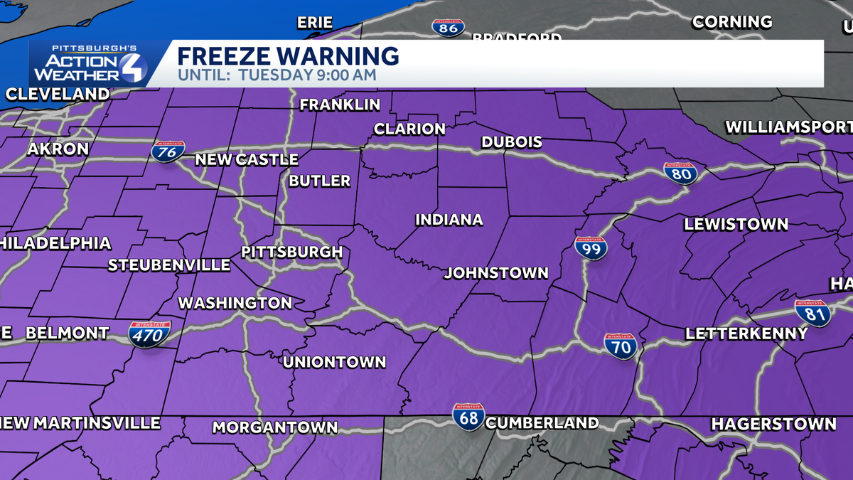
Freeze warning for Western Pennsylvania until Tuesday morning
BEAVER, 41 IN INDIANA AND LOW TEMPERATURES FOR TOMORROW MORNING. THIS IS WHERE WE’RE HEADING DOWN INTO THE 20S, 27 FOR WASHINGTON, 26 IN GREENSBURG, 24 BUTLER AND 27 IN BEAVER AND NEWCASTLE AT 25 DEGREES. AS WE TAKE A LOOK AT THE REST OF THE WEEK, YOU CAN SEE THE SHOWERS THAT WILL BE COMING IN ON WEDNESDAY. 70 DEGREES FOR YOUR HIGH TEMPERATURE. WE GET RID OF THE SHOWERS VERY EARLY ON WEDNESDAY, THEN IT’S DRY THROUGH WEDNESDAY, THURSDAY AS WELL AS FRIDAY. WE KEEP THE TEMPERATURES UP TO 78 AND 80 DEGREES. SO TWO DAYS. IT SHOULD BE VERY NICE. THERE’S A SLIGHT CHANCE WE COULD HAVE SOME RAIN SHOWERS ARRIVE VERY LATE ON FRIDAY NIGHT, BUT WE’RE EXPECTING THOSE TO ARRIVE AS WE GET INTO THE MORNING HOURS ON SATURDAY. TEMPERATURES WILL DROP OFF WITH THE COLD FRONT RUNNING THROUGH, SO THAT WILL TAKE OUR HIGH TO 73 DEGREES. WE KEEP IT IN THE LOW 70S ON SUNDAY AS WELL AS MONDAY, SO SUNDAY SHOULD BE A PRETTY NICE WAY TO FINISH OFF THE WEEKEND. SO FOR TOMORROW, WE’LL START WITH MOSTLY CLEAR SKIES. IT’S GOING TO THOSE TEMPERATURES TO REALLY DROP DOWN INTO THE 20S. WE’LL ADDING CLOUDS AS WE GO THROUGH THE DAY ON TUESDAY. HERE’S YOUR WEDNESDAY MORNING AND THE RAIN SHOWERS. THIS IS 4:00 IN THE MORNING. THIS IS LIKELY GOING TO BE OUT OF HERE BY ABOUT SIX, 7:00 IN THE MORNING. AND WE’LL ACTUALLY SEE SOME SUNSHINE. CLOUDS WILL DECREASE AS WE GO THROUGH THE DAY ON WEDNESDAY. AND THEN WE TAKE IT INTO THURSDAY, WHERE WE WILL BE SEEING MOSTLY SUNNY TO PARTLY CLOUDY SKIES AND KEEPING IT DRY AS WE TAKE A LOOK AT THE NEXT FOUR DAY PLUS FOR MORE. A COOLER DAY ON TUESDAY, ESPECIALLY IN THE MORNING WITH TEMPERATURES IN THE 20S. BUT LOOK AT THIS RUN 66, 70, 78, 80 DEGREES.
Freeze warning for Western Pennsylvania until Tuesday morning

Updated: 7:54 PM EDT Apr 20, 2026
Western Pennsylvania is under a freeze warning from late Monday night into Tuesday morning.With temperatures expected to dip below freezing, the National Weather Service has issued a freeze warning from 11 p.m. Monday through 9 a.m. Tuesday.More: Read the weather alert for your countySign up: Get severe weather alerts to your phone or emailAlready have the WTAE app? Learn how to enable automatic weather alertsConditions will be more ideal for frost development and sub-freezing temperatures overnight. Skies will clear and the wind will calm.The low temperature will be around 30 degrees.Frost and freeze conditions could kill crops and other sensitive vegetation.Looking for more news in your area | Subscribe to the WTAE YouTube Channel
PITTSBURGH —
Western Pennsylvania is under a freeze warning from late Monday night into Tuesday morning.
With temperatures expected to dip below freezing, the National Weather Service has issued a freeze warning from 11 p.m. Monday through 9 a.m. Tuesday.
More: Sign up:
Already have the WTAE app?
Conditions will be more ideal for frost development and sub-freezing temperatures overnight. Skies will clear and the wind will calm.
The low temperature will be around 30 degrees.
Frost and freeze conditions could kill crops and other sensitive vegetation.
Looking for more news in your area | Subscribe to the WTAE YouTube Channel