
The forecast is picking up right where the weekend left off with seasonal temperatures and sunshine. Shower chances return late Wednesday with an Impact Day on Thursday for rain and blustery conditions.Cooldown to finish out OctoberExpect a similar day on Tuesday. It won’t be quite as warm as Monday. Clouds arrive with highs in the lower 50s by Wednesday.Tracking rain with an Impact Day on ThursdayShowers will return Wednesday evening and turn into widespread rain on Thursday, which is an Impact Day. It will also turn blustery as this system wraps through western Pennsylvania. Wind could gust up to 30 mph. The steady rain, which could be heavy at times, will impact and potentially slow down both commutes. Showers still look to linger into Friday morning. By the time rain exits, we could see over an inch of rain across western PA with most of that rain falling on Thursday.Cooler to begin NovemberTrick-or-treaters will have to deal with eerie clouds, temps in the 40’s plus damp and breezy conditions, Friday evening. We stay chilly into the first weekend of November with highs around 50 degrees. Another system will bring the potential for showers late in the weekend. Also, don’t forget to “fall back.” Daylight Saving Time ends at 2 a.m. Sunday. OVERNIGHT: Mainly clear and chilly. Low: 37°.TUESDAY: Slightly cooler, mostly sunny. High: 56°, low: 38°.WEDNESDAY: Increasing clouds with late-day showers. High: 53°. Low: 42°.THURSDAY: Impact Day. Rain showers, heavy at times. gusty winds. High: 53°.
PITTSBURGH —
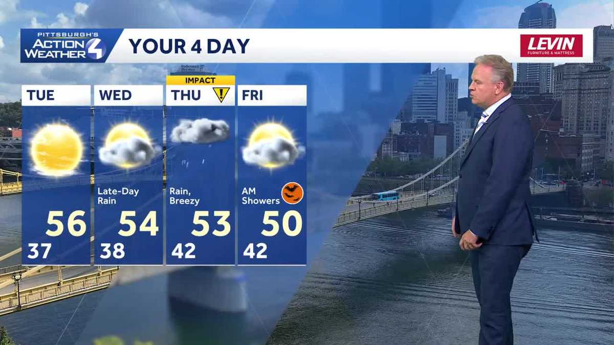
The forecast is picking up right where the weekend left off with seasonal temperatures and sunshine. Shower chances return late Wednesday with an Impact Day on Thursday for rain and blustery conditions.
Cooldown to finish out October
Expect a similar day on Tuesday. It won’t be quite as warm as Monday. Clouds arrive with highs in the lower 50s by Wednesday.

Hearst OwnedHearst
The dry stretch extends through the first half of Wednesday.
Tracking rain with an Impact Day on Thursday
Showers will return Wednesday evening and turn into widespread rain on Thursday, which is an Impact Day. It will also turn blustery as this system wraps through western Pennsylvania. Wind could gust up to 30 mph. The steady rain, which could be heavy at times, will impact and potentially slow down both commutes. Showers still look to linger into Friday morning. By the time rain exits, we could see over an inch of rain across western PA with most of that rain falling on Thursday.

Hearst OwnedHearst
Showers return late Wednesday. An Impact Day is head for Thursday with all-day rain and up to 30 mph gusts.
Cooler to begin November
Trick-or-treaters will have to deal with eerie clouds, temps in the 40’s plus damp and breezy conditions, Friday evening. We stay chilly into the first weekend of November with highs around 50 degrees. Another system will bring the potential for showers late in the weekend. Also, don’t forget to “fall back.” Daylight Saving Time ends at 2 a.m. Sunday.

Hearst OwnedHearst
Temperatures remain on the chilly side for the early days of November.
OVERNIGHT: Mainly clear and chilly. Low: 37°.
TUESDAY: Slightly cooler, mostly sunny. High: 56°, low: 38°.
WEDNESDAY: Increasing clouds with late-day showers. High: 53°. Low: 42°.
THURSDAY: Impact Day. Rain showers, heavy at times. gusty winds. High: 53°.