
Mostly sunny and warmer, isolated shower chance this evening in south-central Pennsylvania
We end the evening on a drier note, then upper 70s are on tap Thursday. The weekend ahead starts off wet, but looking like a drier end.
YOU REJECT SOMETHING? LOOK AT THEIR LITTLE ONE WALKING TOWARDS HER. I KNOW IT’S SURPRISING HOW BIG THEY GET. JUST IN A COUPLE OF DAYS. AND RYAN, HAPPY EARTH DAY TO YOU. HOW ARE YOU FEELING? WE’RE FEELING, WE’RE FEELING, FEELING VERY EARTHY. AND YOU KNOW WHAT? WHAT BETTER WHAT BETTER SUBJECT TO GET INTO ABOUT THE EARTH WHEN WE TALK ABOUT THE WEATHER, LOOK AT THIS BLUE SKIES TODAY. WE’RE SO FAR THIS AFTERNOON GETTING INTO THE EVENING. HAD SOME SHOWERS EARLIER THIS MORNING, BUT YOU CAN SEE OVER LANCASTER SKY CAM JUST SEEING SOME BLUE SKIES ACROSS THE AREA AND A COUPLE HIGH LEVEL CLOUDS. BUT OTHER THAN THAT, NOTHING TOO MUCH TO WRITE HOME. ABOUT 64 DEGREES. SO CERTAINLY FEELING NICE OUT THERE IS WHAT I WOULD SAY WITH THE CALM EAST NORTHEASTERLY BREEZE. I’D SAY RIGHT AROUND FIVE MILES PER HOUR IN IN LANCASTER AT THIS TIME. BUT THAT WARMING TREND WILL CONTINUE AS WE HEAD INTO OUR THURSDAY AFTERNOON. WE’LL START TO SEE THE UPPER 70S FOR THE AREA, AND IT WILL BE A BIT OF A WET START TO THE WEEKEND, ALTHOUGH IF YOU HAVE PLANS FOR THE WEEKEND, I WOULD SAY IF YOU IF YOU’RE ABLE TO, I WOULD SAVE THOSE PLANS FOR SUNDAY BECAUSE SUNDAY DOES LOOK LIKE IT’S GOING TO BE THE DRIER HALF OF THE WEEKEND. AND THEN AS WE HEAD INTO NEXT WEEK, WE ARE LOOKING AT 60S FOR THE ENTIRETY OF THE WEEK WITH THE NEXT BEST CHANCE OF SHOWERS FOR NEXT WEEK WILL BE TUESDAY. WE’LL CHAT ABOUT THAT HERE IN THE FULL TEN DAY FORECAST IN A FEW MINUTES. SO WE’LL SEE A FEW CLOUDS AS WE GET INTO THE REST OF THIS EVENING. TEMPERATURES WILL START TO LOWER THROUGH THE LOWER 60S THEN FOR TONIGHT WILL BOTTOM OUT INTO THE LOWER 50S 50 DEGREES TO BE EXACT. MOSTLY CLEAR AND MILD FOR THIS TIME OF THE YEAR. THEN WE’LL WE’LL JUMP UP TO RIGHT AROUND 76 DEGREES FOR TOMORROW AFTERNOON. WE’LL HAVE MOSTLY SUNNY CONDITIONS. FEELING PLEASANT, FEELING WARMER OUT THERE. SO ANY WARM WEATHER LOVERS TOMORROW IS DEFINITELY GOING TO BE A GOOD DAY. WE’LL SEE SOME MOSTLY SUNNY SKIES FOR YOU, BUT THEN AS WE HEAD INTO TOMORROW AFTERNOON, THE DOWNSIDE THE TREE POLLEN LEVELS, THEY’RE GOING TO BE VERY HIGH FOR THE AFTERNOON. LOW MOLD LEVELS, MODERATE AIR QUALITY AND A MODERATE UV INDEX. WE HAVE ABOUT A 35 MINUTE BURN TIME ON TAP AS WE HEAD INTO THE AFTERNOON. WHAT’S ALSO ON TAP WILL BE A FEW MORE SHOWER CHANCES AS WE HEAD INTO OUR FRIDAY. SO TOMORROW LOOKING DRY AND THE MAJORITY OF THE DAY I WOULD SAY FOR FRIDAY LOOKS DRY. IT’S. ONCE WE GET INTO LATER IN THE DAY, THAT’S WHEN WE’LL START TO SEE THOSE. A FEW OF THOSE RAIN SHOWER CHANCES START TO COME INTO THE PICTURE. THEN WE’RE LOOKING AT A FEW ON AND OFF SHOWERS AS WE HEAD INTO OUR SATURDAY. LIKE I MENTIONED BEFORE, SATURDAY LOOKS LIKE IT’S GOING TO BE THE WETTER HALF OF THE WEEKEND. SUNDAY IS GOING TO BE THE DRIER HALF, SO WE’LL SEE. LOOKING AT A DRIER DAY FOR YOUR SUNDAY AND TEMPERATURES INTO THE 60S AND 70S. LOOK AT THIS. 72 IN YORK, 77 IN IN GETTYSBURG, 75 IN CHAMBERSBURG AT THIS TIME, AND ALSO 75 IN LEWISTOWN. SO CERTAINLY FEELING LIKE A MILD DAY OUT THERE. STORM TEAM, LIVE RADAR NETWORK. ALL IS QUIET RIGHT NOW FOR THE MOST PART. JUST SEEING SOME CLOUDS STARTING TO BUBBLE UP ACROSS THE AREA. AND AGAIN, WE COULD BE SEEING AN ISOLATED SHOWER CHANCE AS WE HAVE THIS COLD FRONT CONTINUE TO MOVE THROUGH AS WE HEAD INTO OUR THURSDAY. THEN HEADING INTO THURSDAY EVENING, YOU CAN SEE AS WE HEAD INTO OUR THURSDAY. LOOKS LIKE WE DO HAVE ANOTHER WARM FRONT THAT’S GOING TO PUSH THROUGH AND THAT’S GOING TO ALLOW FOR ANOTHER SHOWER CHANCE. AS WE HEAD INTO OUR FRIDAY EVENING. SO THURSDAY IS LOOKING DRY MAJORITY OF THE DAY. FRIDAY LOOKS DRY JUST WHEN WE GET INTO LATER IN THE EVENING. NOW WE HAVE A LITTLE BIT OF A SHOWER CHANCE. IT’S GOING TO START TO COME THROUGH. THAT’S GOING TO ALLOW FOR FOR SOME SHOWER CHANCES. BUT LOOK AT THE HIGH TEMPERATURE TREND AS WE HEAD INTO OUR THURSDAY AND FRIDAY INTO THE 70S AND A LITTLE BIT BELOW AVERAGE FOR SATURDAY AND SUNDAY, 66, WE’RE CONSISTENTLY INTO THE 60S. AS WE HEAD INTO NEXT WEEK. YOU CAN SEE IN THE TEN DAY FORECAST HERE LOOKING A LITTLE BIT MORE SEASONABLE HEADING INTO NEXT WEEK, BUT A GOOD CHANCE OF SOME SHOWERS AS WE HEA
Mostly sunny and warmer, isolated shower chance this evening in south-central Pennsylvania
We end the evening on a drier note, then upper 70s are on tap Thursday. The weekend ahead starts off wet, but looking like a drier end.

Updated: 4:31 PM EDT Apr 22, 2026
Mostly sunny skies are on tap for the rest of the evening. A weak cold front will arrive later this evening, which may trigger the chance for an isolated shower. Expect light winds and seasonable highs in the upper 60s to near 70 degrees.Tonight, lows will fall to 50 under mostly clear skies. Much warmer than the 20s we had just a few days ago!Thursday will be the warmest day of the week, as highs reach the upper 70s. Look for plentiful sunshine and a light northwesterly breeze.A warm front will move into western Pennsylvania on Friday. A few showers are possible under partly to mostly cloudy skies. Temperatures will be cooler due to the clouds, near 70 degrees.Widespread light rain is likely on Saturday, as low pressure crosses the state. Highs will be cooler, in the mid-to-upper 50s.Sunday will be the drier half of the weekend. Look for gradual clearing and milder highs in the low 60s.We’ll have dry weather to start the workweek, with seasonable highs in the mid-60s. As a cold front approaches on Tuesday, widespread rain is likely. Highs will cool to 60 degrees.A few showers are possible Wednesday through Friday. Temperatures will remain steady in the low-to-mid 60s, and lows will fall to the upper 40s.
Mostly sunny skies are on tap for the rest of the evening. A weak cold front will arrive later this evening, which may trigger the chance for an isolated shower. Expect light winds and seasonable highs in the upper 60s to near 70 degrees.
Tonight, lows will fall to 50 under mostly clear skies. Much warmer than the 20s we had just a few days ago!
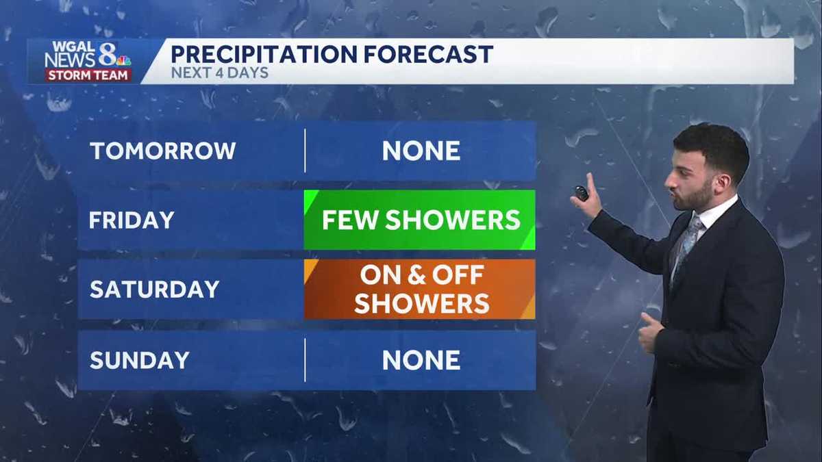
Thursday will be the warmest day of the week, as highs reach the upper 70s. Look for plentiful sunshine and a light northwesterly breeze.
A warm front will move into western Pennsylvania on Friday. A few showers are possible under partly to mostly cloudy skies. Temperatures will be cooler due to the clouds, near 70 degrees.
Widespread light rain is likely on Saturday, as low pressure crosses the state. Highs will be cooler, in the mid-to-upper 50s.
Sunday will be the drier half of the weekend. Look for gradual clearing and milder highs in the low 60s.
We’ll have dry weather to start the workweek, with seasonable highs in the mid-60s. As a cold front approaches on Tuesday, widespread rain is likely. Highs will cool to 60 degrees.
A few showers are possible Wednesday through Friday. Temperatures will remain steady in the low-to-mid 60s, and lows will fall to the upper 40s.