
NFL Draft: Warm and mostly dry for Pittsburgh
The best chance at rain is Saturday morning, prompting an Impact Day.
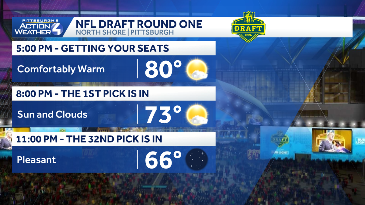
BRIAN. YEAH. THE WEATHER COOPERATING FOR US ACROSS WESTERN PENNSYLVANIA. IT’S ALMOST LIKE MOTHER NATURE KNOWS WE HAVE GUESTS COMING TO TOWN AND IS ON HER BEST BEHAVIOR. TEMPERATURES ARE PRETTY NICE OUT THERE. WE’RE STILL HOVERING CLOSE TO 80 DEGREES AS YOU GET READY FOR THE DRAFT THEATER TO FULLY OPEN HERE AT 5:00 AS THE FIRST PICK ROLLS IN AT 8:00. TEMPERATURES STILL IN THE 70S WILL BE IN THE 60S. AS WE GET TO THE END OF THE FIRST ROUND. A LITTLE BIT LATER ON TODAY, TOMORROW, PRETTY NICE AS WELL. WE’LL POP UP TO 82, A LITTLE WARMER. WE ARE WATCHING FOR A FEW POP UP SHOWERS DEVELOPING TOMORROW AFTERNOON. A LITTLE BETTER COVERAGE THAN WHAT WE WILL SEE FOR THE REST OF THE DAY TODAY. AND THEN SATURDAY IS AN IMPACT DAY AS RAIN SHOWERS WILL BE AROUND IN THE MORNING. WE WILL ATTEMPT TO CLEAR THOSE OUT BEFORE ROUND FOUR STARTS AT NOON ON SATURDAY. AGAIN, THE WEATHER IS FAIRLY QUIET. THERE HAVE BEEN A COUPLE OF SHOWERS POPPING BACK INTO OHIO. EVEN A FEW THUNDERSTORMS. WE’LL BE WATCHING THESE AS THEY TRY TO SLIDE INTO WESTERN PENNSYLVANIA, THE ONE THAT’S BEEN OUT AHEAD OF IT NOW APPROACHING WEST VIRGINIA, PANHANDLE HAS BEEN STRUGGLING TO SURVIVE, AND WE’LL HOPE TO KEEP THINGS DRY, ESPECIALLY AROUND DOWNTOWN, AS WE HEAD THROUGH THE COURSE OF THE NEXT FEW HOURS. AGAIN, 82 TOMORROW, 69 FOR US ON SATURDAY, OUR IMPACT DAY 65 FOR US ON SUNDAY. THEN RAIN CHANCES RETURN LATE MONDAY INTO TUESDAY. THAT’S WITH ANOTHER COLD FRONT THAT WILL KNOCK TEMPERATURES BACK INTO THE 60S WITH ANOTHER RAIN CHANCE GETTING HERE NEXT FRIDAY. THAT LIKELY COOLS US DOWN EVEN MORE AS WE HEAD INTO MARATHON WEEKEND. SO AGAIN, A LOT OF SHOWER PASSING THROUGH OVER THE COURSE OF THE NEXT FEW HOURS, BUT ANY OF THESE WILL FALL APART ONCE WE GET PAST SUNSET. WE SHOULD BE DRY OUT THE DOOR TOMORROW AND THEN TOMORROW AFTERNOON. SHOWERS WILL BUBBLE UP THROUGH THE HEATING OF THE DAY, GENERALLY NORTH AND EAST OF PITTSBURGH, BUT SHOWERS WILL BE AROUND HERE. 7:00 AS ROUND TWO STARTS AGAIN. SHOWERS MAINLY NORTH AND EAST OF PITTSBURGH. THEN OUR COLD FRONT STARTS ARRIVING AFTER WE GET PAST. AROUND THREE SHOWERS PASS THROUGH OVERNIGHT. THEY’LL STILL BE AROUND SATURDAY MORNING, BUT THEY’LL START CLEARING AROUND NOON, AND THEN THE REST OF THE AFTERNOON WILL JUST FEATURE CLOUDS. AS WE HEAD THROUGH THE DAY ON SATURDAY. THAT’S REALLY THE ONLY BLEMISH IN THE FORECAST. OTHERWISE DRY CONDITIONS AS WE HEAD THROUGH THE WEEKEND, PARTLY CLOUDY SKIES ON ACTION. CAM 78 IS THE CURRENT TEMPERATURE. WINDS ARE WEST AT TEN, GUSTING TO 20. A NICE WARM BREEZE. YOU’LL WAN
NFL Draft: Warm and mostly dry for Pittsburgh
The best chance at rain is Saturday morning, prompting an Impact Day.

Updated: 4:27 PM EDT Apr 23, 2026
Temperatures are warming up and will remain warm through late week. A cold front Saturday morning will bring rain showers and prompts an Impact Day.NFL Draft forecastFriday will be terrific with comfortable temperatures in the low 80s during the day. Clouds will increase late Friday as we watch the approach of another cold front.A pop-up shower can’t be ruled out on Friday, especially north and east of Pittsburgh, but most of the region remains dry. A cold front approaching late Friday night, closer to 11 p.m., and into early Saturday morning will bring scattered rain showers. Saturday morning will be an Impact Day, but the rain doesn’t last long; we will see a clearing in the afternoon.Slightly cooler this weekend and next weekSaturday’s showers will cool temperatures off. The dip in temperature extends into next week with highs in the 60s. Another round of showers will arrive late Monday and Tuesday. Tuesday’s rain will likely be the most we see over the course of the next week. Temperatures remain steady until another cold front brings more rain next Friday and cooler temperatures for Marathon weekend.TONIGHT: Partly cloudy. Low 57°.FRIDAY: Warm with increasing clouds. Showers are possible late. High: 82°, low 59°.SATURDAY – Impact Day: Rain possible at times, especially in the morning. High: 69°, low: 48°.SUNDAY: Partly cloudy. High: 65°, low: 46°.
PITTSBURGH —
Temperatures are warming up and will remain warm through late week. A cold front Saturday morning will bring rain showers and prompts an Impact Day.
NFL Draft forecast
Friday will be terrific with comfortable temperatures in the low 80s during the day. Clouds will increase late Friday as we watch the approach of another cold front.

A pop-up shower can’t be ruled out on Friday, especially north and east of Pittsburgh, but most of the region remains dry. A cold front approaching late Friday night, closer to 11 p.m., and into early Saturday morning will bring scattered rain showers. Saturday morning will be an Impact Day, but the rain doesn’t last long; we will see a clearing in the afternoon.

Slightly cooler this weekend and next week
Saturday’s showers will cool temperatures off. The dip in temperature extends into next week with highs in the 60s. Another round of showers will arrive late Monday and Tuesday. Tuesday’s rain will likely be the most we see over the course of the next week. Temperatures remain steady until another cold front brings more rain next Friday and cooler temperatures for Marathon weekend.

Hearst Owned
Summer-like to end the week with rain showers Saturday and then again on Tuesday.
TONIGHT: Partly cloudy. Low 57°.
FRIDAY: Warm with increasing clouds. Showers are possible late. High: 82°, low 59°.
SATURDAY – Impact Day: Rain possible at times, especially in the morning. High: 69°, low: 48°.
SUNDAY: Partly cloudy. High: 65°, low: 46°.