
Mild Friday With Few PM Showers; More Rain Saturday In South-Central Pennsylvania
Highs will reach the upper 70s today, then fall to 70 degrees on Friday.
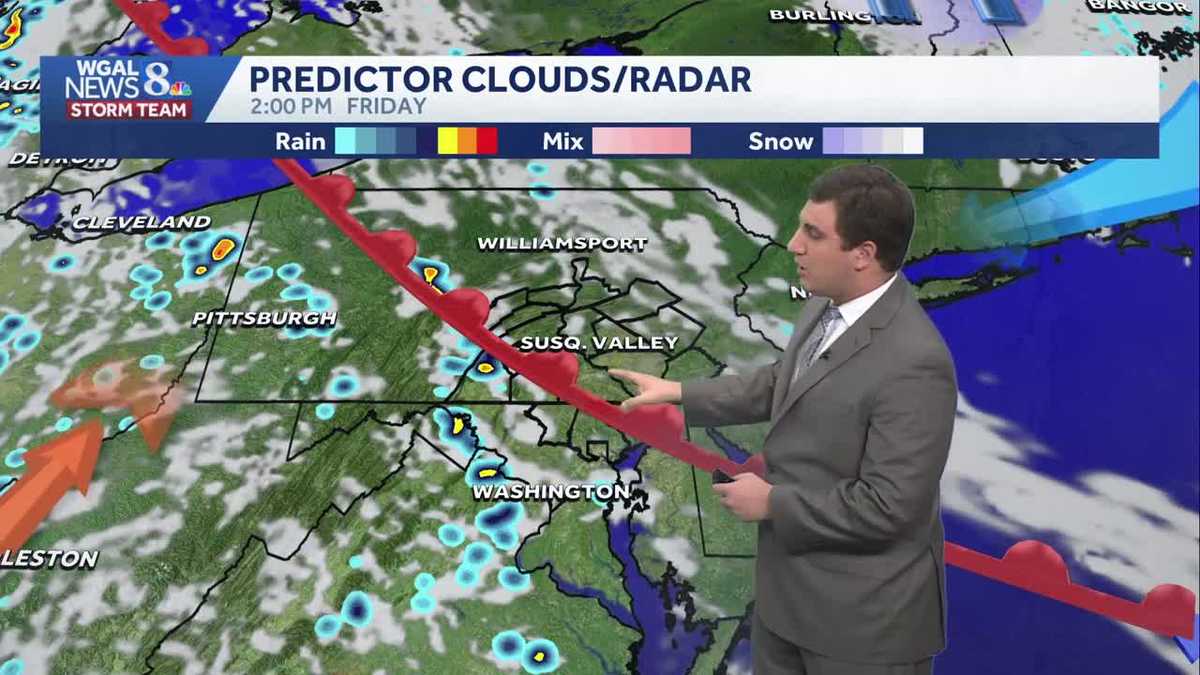
TREATED BY A TRAUMA UNIT. THE OTHER FOUR HAVE MINOR INJURIES. NOW, THE WGAL NEWS EIGHT STORM TEAM FORECAST WITH METEOROLOGIST MIKE SUSKO. GOOD EVENING EVERYONE. ONE MORE MILD DAY COMING OUR WAY WITH HIGHS NEAR 70 DEGREES ON OUR FRIDAY. IT WILL BE A WET START TO THE WEEKEND AS WE’LL SEE SOME SHOWERS AS WE HEAD INTO SATURDAY, ESPECIALLY DURING THE AFTERNOON AND THEN DRIER CONDITIONS ON SUNDAY. NEXT WEEK WILL BE MAINLY IN THE 60S, THOUGH MAYBE A DAY OR SO GETTING CLOSE TO THAT 70 DEGREE MARK. BUT IT’S GOING TO BE A LITTLE BIT MORE COOLER ACROSS THE AREA, WITH THE BEST CHANCE OF RAIN NEXT WEEK ON TUESDAY. THE LEBANON. RIGHT NOW IT IS QUIET ACROSS THE AREA AND IT’S A PRETTY COMFORTABLE NIGHT. 64 IN LEBANON AT THE MOMENT, 65 IN LANCASTER. IT’S 64 IN HARRISBURG AS WELL AS CARLISLE AND 57 IN CASHTOWN. AS WE GO THROUGH THE NIGHT TONIGHT, WE’LL DROP BACK TO AROUND 52 DEGREES FOR MOST OF THE AREA. SOME OF YOU WHO ARE A LITTLE BIT COOLER THAN SOME OF THE SURROUNDING AREAS MAY GET DOWN INTO THE UPPER 40S, BUT NONETHELESS, IT’S GOING TO BE A RELATIVELY MILDER NIGHT ACROSS THE REGION UP TO 60 DEGREES. ONCE THE SUN COMES UP AND THEN 70 TOMORROW AFTERNOON WITH CLOUDS AND SUN AND A FEW AFTERNOON SHOWERS. TOMORROW’S WEATHER AND HEALTH, THE POLLEN LEVELS GOING TO STAY HIGH, AND THAT’S GOING TO BE THE CASE REALLY, UNTIL WE CAN GET THE WIDESPREAD RAIN IN HERE ON SATURDAY. THAT SHOULD HELP LOWER, AT LEAST TEMPORARILY, AS WE GO INTO THE WEEKEND. SO FOR ALLERGY SUFFERERS, HOPEFULLY GET A LITTLE BIT OF BREAK HERE WITH THE WIDESPREAD RAIN ON SATURDAY. THE REASON FOR THAT RAIN IS GOING TO BE THIS COLD FRONT. A LOT OF SEVERE WEATHER ACTUALLY OUT IN PARTS OF THE CENTRAL PLAINS. THERE WAS A LARGE TORNADO IN PARTS OF OKLAHOMA EARLIER THAT THANKFULLY HAS DISSIPATED. BUT HERE THIS SYSTEM WILL EVENTUALLY MOVE INTO THE SUSQUEHANNA VALLEY. THE GOOD NEWS IS WE DON’T GET THE SEVERE WEATHER PART OF IT. WE’LL JUST GET A LITTLE BIT OF RAIN AS WE GO THROUGH THE NIGHT. TONIGHT WE WILL SEE A COLD FRONT, A WARM FRONT THERE IN RED. MOVE INTO THE SUSQUEHANNA VALLEY, AND THEN TOMORROW AFTERNOON, RIGHT AROUND TWO, 3:00, YOU’LL START TO SEE A FEW A LITTLE POP UP SHOWERS, MAYBE A RUMBLE OF THUNDER IN THE AFTERNOON, BUT IT’S NOT GOING TO BE ANYTHING SEVERE, JUST MORE OF THAT NUISANCE RAIN THAT YOU CAN GET SOMETIMES IN THE SPRING. AS WE GO THROUGH TOMORROW EVENING AND NIGHT, WE’LL START TO SEE A LITTLE BIT MORE RAIN ACROSS THE AREA. SCATTERED SHOWERS ACROSS PARTS OF THE REGION WITH A LITTLE MORE STEADIER RAIN NORTH OF THE PENNSYLVANIA TURNPIKE HERE, AS WE HEAD INTO SATURDAY MORNING. BUT THEN IN THE AFTERNOON, MOST OF THE AREA, IF NOT EVERYONE, IS GOING TO SEE THAT STEADIER RAIN AS THE COLD FRONT ACTUALLY PUSHES ON THROUGH. IT LOOKS LIKE IT’S GOING TO BE RIGHT AROUND LUNCHTIME, MAYBE A LITTLE BIT AFTER THAT. ON SATURDAY, WE GET THAT STEADY RAIN AND THEN IT MOVES OUT AS WE HEAD TOWARDS SATURDAY EVENING, AND BY SUNDAY WE’RE DRY. HOW MUCH RAIN? GENERALLY A QUARTER TO A HALF AN INCH OF RAIN. SOME OF YOU MAY GET AS MUCH AS AN INCH IN PARTS OF THE AREA, BUT IT’S NOT GOING TO BE A HEAVY RAIN. IT’S NOT GOING TO ALL COME DOWN AT ONCE. SO FLOODING IS NOT AN ISSUE. WE’LL DEFINITELY TAKE IT THOUGH. HERE’S A LOOK AT THE UPDATED DROUGHT MONITOR. WE DO HAVE SEVERE DROUGHT IN PARTS OF LEBANON, BERKS, CHESTER, LANCASTER AND YORK COUNTY. THAT IS THE DARK ORANGE YOU SEE THERE IN CHAMBERSBURG, FRANKLIN COUNTY AND ALONG THE TURNPIKE AND SOUTH OF THE TURNPIKE. YOU’RE IN A MODERATE DROUGHT, SO WE DO NEED THE RAIN. AND TO GET RID OF THIS ENTIRELY, WE WOULD NEED ABOUT 8 TO 10IN OF RAIN. WE’RE NOT GOING TO GET THAT MUCH AS WE GO INTO THE WEEKEND, BUT AT LEAST WE WILL HELP MITIGATE AT LEAST SOME OF THAT AS WE GO THROUGH SATURDAY. AND THE GOOD NEWS IS THERE’S MORE CHANCES FOR RAIN NEXT WEEK. WE GET A BREAK ON SUNDAY AND MONDAY. BOTH DAYS ARE DRY AND MONDAY IS LOOKING MAGNIFICENT THERE WITH A HIGH OF 68. WE’LL GET MORE RAIN ON TUESDAY AND A LITTLE BIT OF SHOWERS HERE WEDNESDAY AND THURSDAY OF NEXT WEEK WITH ANOTHER SYSTEM TOWARDS THE END OF THE WEE
Mild Friday With Few PM Showers; More Rain Saturday In South-Central Pennsylvania
Highs will reach the upper 70s today, then fall to 70 degrees on Friday.

Updated: 11:20 PM EDT Apr 23, 2026
Good evening,Tonight, lows will fall to the low 50s under partly cloudy to mostly clear skies.A warm front will move into western Pennsylvania on Friday. A few showers are possible throughout the day, especially west of the Susquehanna River. Look for partly to mostly cloudy skies and cooler temperatures near 70.Widespread periods of light rain are likely Saturday morning into the early afternoon, as low pressure crosses the state. Rain will taper to showers by mid-afternoon, and the evening will be mainly dry. However, highs will be much cooler, in the mid-50s, thanks to an easterly breeze. Rain totals will range from 0.25″ to 0.50″.Sunday will be the drier half of the weekend. Any showers will end early in the morning, then look for mostly cloudy skies and milder highs near 60. Some clearing is possible late.We’ll have a dry and sunny start to the workweek, with seasonable highs in the upper 60s. As a cold front approaches on Tuesday, widespread rain is likely. Highs will cool to 60 degrees.A few showers are possible on Wednesday and Thursday. Temperatures will remain steady in the mid-to-upper 60s, and lows will fall to the upper 40s. A slightly better chance of showers arrives Friday into Saturday.Have a great night!
Good evening,
Tonight, lows will fall to the low 50s under partly cloudy to mostly clear skies.
A warm front will move into western Pennsylvania on Friday. A few showers are possible throughout the day, especially west of the Susquehanna River. Look for partly to mostly cloudy skies and cooler temperatures near 70.
Widespread periods of light rain are likely Saturday morning into the early afternoon, as low pressure crosses the state. Rain will taper to showers by mid-afternoon, and the evening will be mainly dry. However, highs will be much cooler, in the mid-50s, thanks to an easterly breeze. Rain totals will range from 0.25″ to 0.50″.
Sunday will be the drier half of the weekend. Any showers will end early in the morning, then look for mostly cloudy skies and milder highs near 60. Some clearing is possible late.
We’ll have a dry and sunny start to the workweek, with seasonable highs in the upper 60s. As a cold front approaches on Tuesday, widespread rain is likely. Highs will cool to 60 degrees.
A few showers are possible on Wednesday and Thursday. Temperatures will remain steady in the mid-to-upper 60s, and lows will fall to the upper 40s. A slightly better chance of showers arrives Friday into Saturday.
Have a great night!