
More rain & cooler Saturday; drier for Sunday across south-central Pennsylvania
Saturday is looking like the wetter half of the weekend with Sunday looking to remain dry. Next week will start off on a warmer & pleasant note.
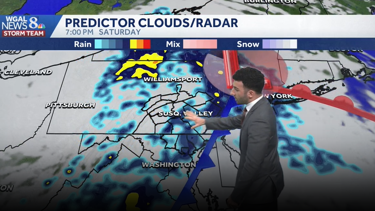
WGAL NEWS EIGHT. NOW WGAL NEWS EIGHT STORM TEAM FORECAST WITH METEOROLOGIST BRIAN ARGENTI. WE’RE TRACKING SOME SHOWERS AS WE HEAD INTO THE WEEKEND. THE MAIN DAY THAT’S GOING TO BE LOOKING THE WETTEST IS GOING TO BE OUR SATURDAY, BUT STILL LOOKING AT SOME ISOLATED SHOWER CHANCES FOR TONIGHT. IT WILL BE A WET START TO THE WEEKEND, A DRIER END, AND THEN WE’LL SEE SOME RAIN AT TIMES AS WE HEAD INTO NEXT WEEK WITH THE BEST CHANCE OF SHOWERS BEING TUESDAY OF NEXT WEEK. MADE IT TO 76 TODAY AT HARRISBURG INTERNATIONAL AIRPORT, BUT USUALLY FOR THIS TIME OF YEAR WE EXPECT 67 DEGREES, SO WE’RE ALMOST TEN DEGREES ABOVE AVERAGE FOR THIS TIME OF THE YEAR. WE HAD ABOUT A TRACE OF SOME RAINFALL RECORDED AT HARRISBURG INTERNATIONAL AIRPORT, BUT WE’LL DROP DOWN TO THE 50S OVERNIGHT. TONIGHT. WE’LL SEE MOSTLY CLOUDY CONDITIONS AND SOME ISOLATED SHOWERS DURING THE DAY OR FOR TONIGHT AND THEN FOR TOMORROW MORNING. A FEW SHOWERS STILL LOOKING COOLER. WE’LL BE DOWN INTO THE LOWER 50S AND HEADING INTO THE AFTERNOON. WE’RE GOING TO BE CONSISTENTLY INTO THE LOWER TO MID 50S. AS YOU CAN SEE, RIGHT AROUND 54 DEGREES IS WHAT WE’RE EXPECTING FOR THE AFTERNOON REMAINING. COOL. IT WILL BE BREEZY TOO, AS WE HEAD INTO THE AFTERNOON AND WEATHER FOR THE DAY TOMORROW. POLLEN LEVELS ARE GOING TO BE HIGH FOR THE TREES, BUT WE’LL HAVE LOW MOLD LEVELS. AIR QUALITY IS GOOD. WE’LL HAVE A LOW UV INDEX. WE’LL HAVE ABOUT A 50 MINUTE OR 55 MINUTE BURN TIME AS WE HEAD INTO THE AFTERNOON. BUT THAT’S ALL THANKS TO SOME OF THE SHOWERS THAT WE’LL SEE FOR OUR SATURDAY. SO WE’LL SEE A FEW MORNING SHOWERS, AND THEN THEY’LL START TO BECOME A LITTLE BIT MORE PERSISTENT AS WE HEAD INTO THE AFTERNOON. WE’LL HAVE MORE. SO RAIN STARTING TO COME INTO THE AS WE GET INTO THE MIDDLE OF THE AFTERNOON, YOU CAN SEE HIGHS ONLY REALLY INTO THE LOWER 50S. SO IF YOU HAVE ANY PLANS FOR THIS WEEKEND, I WOULD SEE IF YOU CAN PUSH THEM OR POSTPONE THEM TO SUNDAY WHERE WE’LL BE SEEING SOME DRIER CONDITIONS. NOW WE’LL SEE SOME MORNING SHOWERS FOR SUNDAY, BUT THE MAJORITY OF THE DAY IS ONCE WE HEAD INTO LATER IN THE MORNING, INTO THE AFTERNOON, THAT’S WHEN WE REALLY START TO SEE SOME CLEARING SKIES AND THINGS WILL START TO DRY OUT FOR US. BUT WE’RE INTO THE 60S RIGHT NOW AND WE’RE INTO THE UPPER 50S FOR LEWISTOWN AT THIS TIME. STILL WATCHING THIS BATCH OF SOME SHOWERS BEGINNING TO MOVE THROUGH. BUT HERE COMES SOME OF THOSE ISOLATED SHOWERS STILL KIND OF OFF TOWARDS OUR WEST. AND THEN HERE COMES THE SWATH OF SHOWERS OFF TO THE WEST, NOW IN DOOR TOWARDS OHIO. THAT’S GOING TO START TO MOVE IN AND ALLOW THE CHANCE FOR SOME SHOWERS, ESPECIALLY DURING THE AFTERNOON. SO LET ME TIME IT OUT FOR YOU. SO WE WE SEE SOME SHOWER CHANCES FOR THE MORNING. LATER IN THE MORNING. YOU CAN SEE STILL SEEING A FEW SPOTS OF SOME OF SOME RAIN SHOWERS. WE DO HAVE THE RACE AGAINST RACISM IN BOTH YORK AND LANCASTER COUNTIES. SO JUST KEEP THIS IN MIND IF YOU’RE GOING TO BE PARTAKING IN THOSE EVENTS FOR TOMORROW. LOOKING AT A FEW MORNING SHOWERS, BUT THE BULK OF THESE SHOWERS WON’T REALLY COME UNTIL WE GET INTO THE AFTERNOON. SO YOU CAN SEE THE WIDER SWATH OF SHOWERS REALLY START TO MOVE IN AS WE HAVE THIS LOW PRESSURE SYSTEM AND COLD FRONT TRAVERSE THE COMMONWEALTH, AND THEN IT BECOMES A LITTLE BIT MORE WIDESPREAD ONCE WE GET INTO THE OVERNIGHT PERIOD SATURDAY. BUT NOTICE THE TIME STAMP RIGHT AROUND 630, 7:00. SO SUNDAY MORNING SERVICES LOOKING AT SOME SHOWERS, BUT THAT WILL SOON CLEAR OUT. AND YOU CAN SEE WE’LL JUST BE MOSTLY CLOUDY AND HIGH PRESSURE WILL START TO BUILD IN. THAT’S GOING TO HELP TO PROMOTE SOME CLEARING AS WE HEAD INTO THE AFTERNOON. NOW WE HAVE SOME VERY BENEFICIAL RAIN, BY THE WAY, WE COULD BE SEEING ABOUT A HALF INCH TO UP TO AN INCH OF SOME RAIN FOR THE ENTIRE AREA. AND THIS IS OUR DROUGHT MONITOR RIGHT NOW. WE ARE UNDER, IN SOME PARTS A SEVERE DROUGHT, ESPECIALLY TOWARDS LANCASTER AND YORK COUNTIES, ALSO TOWARDS FRANKLIN COUNTY. BUT THE MAJORITY OF THE AREA LOOKING AT ABNORMALLY DRY TO MODERATE DROUGHT CONDITIONS. BUT YOU CAN SEE TEMPERATURES WILL BE JUST BELOW AVERAGE FOR THE WEEKEND. BUT THEN WE’LL BE RIGHT AROUND SEASONABLE LEVELS AS WE HEAD INTO NEXT WEEK. AND A CHANC
More rain & cooler Saturday; drier for Sunday across south-central Pennsylvania
Saturday is looking like the wetter half of the weekend with Sunday looking to remain dry. Next week will start off on a warmer & pleasant note.

Updated: 10:34 PM EDT Apr 24, 2026
Overnight, a few showers are possible under mostly cloudy skies. Lows will be mild, around 52 degrees.Saturday’s system has slowed slightly. That’s good news for Saturday morning activities! Expect mainly dry weather to start, then rain developing by afternoon. Widespread rain will taper to showers from west to east by evening. Highs will be much cooler, in the low 50s, thanks to an easterly breeze. Rain totals will range from 0.25″ to 0.50″ in most areas.Sunday will be the drier half of the weekend compared to Saturday. Showers will end early in the morning. By the afternoon, look for mostly cloudy skies and highs near 56°. Some clearing is possible toward evening.We’ll have a dry and sunny start to the workweek, with seasonable highs in the upper 60s. As a cold front approaches late Tuesday, scattered showers will develop. Highs will reach the mid-60s ahead of the front.Showers will end on Wednesday, and highs will be seasonable, in the mid-60s. Thursday looks dry, then the chance of showers returns Friday into Saturday. Highs will stay in the 60s next week, with lows generally in the 40s to near 50 degrees.Have a great rest of your night! ~ Ryan
Overnight, a few showers are possible under mostly cloudy skies. Lows will be mild, around 52 degrees.
Saturday’s system has slowed slightly. That’s good news for Saturday morning activities! Expect mainly dry weather to start, then rain developing by afternoon. Widespread rain will taper to showers from west to east by evening. Highs will be much cooler, in the low 50s, thanks to an easterly breeze. Rain totals will range from 0.25″ to 0.50″ in most areas.
Sunday will be the drier half of the weekend compared to Saturday. Showers will end early in the morning. By the afternoon, look for mostly cloudy skies and highs near 56°. Some clearing is possible toward evening.
We’ll have a dry and sunny start to the workweek, with seasonable highs in the upper 60s. As a cold front approaches late Tuesday, scattered showers will develop. Highs will reach the mid-60s ahead of the front.
Showers will end on Wednesday, and highs will be seasonable, in the mid-60s. Thursday looks dry, then the chance of showers returns Friday into Saturday. Highs will stay in the 60s next week, with lows generally in the 40s to near 50 degrees.
Have a great rest of your night!
~ Ryan