
Wet end to our Saturday, drier Sunday; cooler highs across south-central Pennsylvania
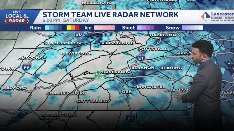
Scattered showers continue through the evening. Rain tapers from showers to a drizzle early Sunday morning. The rest of the day is dry with cloud cover staying put until late in the evening. Temperatures stay below average.
Now the WGAL News 8 storm team forecast with meteorologist Ryan Argenti. Storm Team Live Radar Network still showing some showers making their way through the Susquehanna Valley. You can see the, the bulk of those showers really continuing to move off towards the east, but you can still see to the west, still looking at some more showers that are just in the wake of this low pressure system that was just scooching past the, the Susquehanna Valley. So still looking at *** wet rest of our evening. We’ll see that rain taper to showers as we head into later in the evening. Still *** little bit breezy. And cool, *** little bit of *** light wind out there, and then it’ll be *** drier Sunday. We’ll see some early showers. I do think the showers really move out by 67 o’clock in the morning, and then we’ll see *** dry afternoon with, uh, highs, uh, remaining cool for this time of the year. And then we’ll see 60s next week, but we’ll still see, uh, more shower chances through the next few days, especially as we head to through, uh, Tuesday through Thursday of next week. I’ll show you that in the full 10 day forecast here in just *** minute, but temperatures right around 56 degrees, but you can see average for this time of the year is. 68 degrees, so certainly below average for this afternoon’s highs, but in terms of overnight lows, we hit, we hit *** low of 48 degrees earlier this morning, but we’re, we usually expect 46, so we’re, we’re right around par for this time of the year. Only had about 0.45 inches of rain recorded at Harrisburg International Airport, which is great news because we are certainly dry right now. We’ll get into some of those statistics here in just *** minute, but we’ll expect to see more of those scattered showers through the evening and tonight. Still remaining cool into the forties. Then we’ll top out. Right around 60 degrees for tomorrow afternoon we’ll see those showers ending early in the morning and we’ll start to see some afternoon evening clearing. I, I think the clearing really comes in later in the evening, as I say closer to 7 or 8 o’clock in the evening is when we’ll start to see those skies clear. But pollen levels are going to be high for tomorrow, but mold levels remain low. Air quality is good, and *** low UV index have about *** 50 minute burn time for the afternoon. But in terms of the, so far the recent rain reports in just all between. About *** quarter of an inch to upwards of 0.5 inch or even 6/10 of an inch I’ve seen in some uh some scattered areas, but certainly beneficial rain across the area. Some statistics still *** little bit as of the afternoon climatological reports, still about 1 inch or just over 1 inch below average for the month to date so far and *** little bit below average for the season to date, and we definitely need the rain. We are in *** bit of *** moderate to severe drought situation across the majority of the area, our far northern and western communities. Looking abnormally dry, but good news though, we are looking at some more shower chances as we head into early tomorrow, but especially heading into Tuesday and Wednesday of next week. Still looking at some off and on shower chances. Now temperatures are into the 40s, we’re into the 50s for Gettysburg, Chambersburg, and Lewistown. Still going to continue to watch these showers through the rest of this evening into tonight. They’ll start to clear out as we head into tomorrow morning, so you can see Predictor highlighting that by the morning time right around 7 o’clock in the morning, I think the showers will have ended by. By that point and then as we head through the rest of the afternoon, still looking at mostly cloudy conditions until we get to about 7 or 8 o’clock in the evening where we’ll start to see breaks in the clouds, see some sunshine start to peek through around sunset, and we’ll see mainly clear conditions overnight, uh, tomorrow night getting into our Monday morning. And Monday, look at this, mostly sunny conditions. Yes, we need the rain. It’s good to see some sunshine once again once we get into our Monday, but that’s all thanks to high pressure that’s situated far to our north, just centered right over we’re closer to Ontario. That’s allowing some, uh, some influence in our conditions back home. But here comes some more shower chances for your Tuesday and Wednesday. So we’ll see *** chance of some showers Tuesday and Wednesday, and then heading into Thursday and Friday. Still looking mostly cloudy, and then rain chances return as we head into Saturday and Sunday of next weekend. But notice the temperatures still *** little bit below average as we head into the following week, Monday and Tuesday. Average temperatures are right around 70 degrees, so we’ll continue to watch the temperature trend as we head into next week. Back to you.
Wet end to our Saturday, drier Sunday; cooler highs across south-central Pennsylvania
Scattered showers continue through the evening. Rain tapers from showers to a drizzle early Sunday morning. The rest of the day is dry with cloud cover staying put until late in the evening. Temperatures stay below average.

Updated: 6:54 PM EDT Apr 25, 2026
Scattered showers will continue through the rest of the evening. Temperatures will drop through the mid 40s this evening with winds out of the east between 5 and 15 mph.Tonight, cool conditions remain and temperatures will bottom out in the lower 40s. Showers will last through the majority of the night, but will move out by 5-6am Sunday morning.Morning showers and drizzle ends early Sunday. The rest of the day is mainly overcast with some late day clearing possible. Highs are still cooler than average in the mid to upper 50s.We kick off the week with mostly sunny skies and highs back to more seasonable highs in the upper 60s to around 70°Tuesday is dry for most of the day until the evening when a few showers may move through the Valley. Highs are near the mid 60s.There is a better chance for showers on Wednesday, and temperatures are cooler in the low 60s.Temperatures hover around 60° Thursday and Friday under partly sunny skies and dry conditions.It remains cooler than average through the weekend with highs around 60°. While it is mainly dry, we are watching a system that could bring a few showers. We are back to more seasonable averages in the upper 60s on Monday under partly sunny skies.Have a great rest of your Saturday!~ Ryan
Scattered showers will continue through the rest of the evening. Temperatures will drop through the mid 40s this evening with winds out of the east between 5 and 15 mph.
Tonight, cool conditions remain and temperatures will bottom out in the lower 40s. Showers will last through the majority of the night, but will move out by 5-6am Sunday morning.
Morning showers and drizzle ends early Sunday. The rest of the day is mainly overcast with some late day clearing possible. Highs are still cooler than average in the mid to upper 50s.
We kick off the week with mostly sunny skies and highs back to more seasonable highs in the upper 60s to around 70°
Tuesday is dry for most of the day until the evening when a few showers may move through the Valley. Highs are near the mid 60s.
There is a better chance for showers on Wednesday, and temperatures are cooler in the low 60s.
Temperatures hover around 60° Thursday and Friday under partly sunny skies and dry conditions.
It remains cooler than average through the weekend with highs around 60°. While it is mainly dry, we are watching a system that could bring a few showers. We are back to more seasonable averages in the upper 60s on Monday under partly sunny skies.
Have a great rest of your Saturday!
~ Ryan