
Rainy Days Followed By Cool Temperatures This Week
The Impact Days are for rain Tuesday morning and day’s long rain on Wednesday.
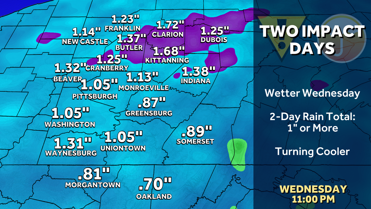
THE NEXT TWO DAYS. YOU MADE THEM BACK TO BACK IMPACT DAYS, RIGHT? YEAH. THAT’S RIGHT. TWO RAIN CHANCES COMING. TOMORROW IS MAINLY IN THE MORNING AND IT’S LIGHT, BUT IT WILL BE DURING THE MORNING COMMUTE. THAT’S WHY IT’S AN IMPACT DAY. WEDNESDAY IS THE MORE IMPACTFUL OVERALL RAIN. WE’LL SEE. MORE RAIN WILL BE WIDESPREAD FOR US. WE HAVE A CHANCE OF SEEING A COUPLE OF THUNDERSTORMS EARLY. WE THEN DRY OUT AND HOPEFULLY YOU HAVEN’T PUT SOME OF THE THICKER GEAR AWAY. YOU MAY WANT THE JACKET BY THE TIME WE GET TO THURSDAY AND BEYOND 71 TOMORROW. ONCE WE CLEAR THOSE SHOWERS OUT IN THE MORNING AGAIN, MOST OF US WILL DRY OUT AS WE GET TO THE END OF THE MORNING COMMUTE, RAIN AND STORMS, SO FORTH. ON WEDNESDAY, AT 64, WE DROP TO THE 50S FOR THURSDAY AND FRIDAY 56, THURSDAY 55 ON FRIDAY. LOWS GO INTO THE 30S ON FRIDAY MORNING AND THEY STAY THERE THROUGH THE WEEKEND. WE WILL LIKELY SEE FROST AND FREEZE ADVISORIES COME OUT FROM THE NATIONAL WEATHER SERVICE 53 ON SATURDAY FOR THE MARATHON AND MARATHON. SUNDAY, 60 DEGREES FOR US, AND THEN WE’LL HOLD IN THE MID 60S AS WE HEAD INTO NEXT WEEK. THE GOOD NEWS RIGHT NOW THE WEEKEND DOES LOOK DRY ONCE WE GET THROUGH OUR RAIN SHOWERS. OVER THE COURSE OF THE NEXT 48 HOURS. SO IF YOU’RE HEADING OUT THIS EVENING, YOU’LL NOTICE CLOUDS THICKENING UP AHEAD OF OUR NEXT SYSTEM THAT BRINGS RAIN SHOWERS IN AS WE HEAD TOWARDS THE VERY BEGINNING OF THE MORNING COMMUTE AND THE FURTHER EAST YOU ARE THE CITY, THE LONGER RAIN WILL HOLD ON. SO IF YOU’RE HEADING, FOR EXAMPLE, FROM GREENSBORO TOWARDS PITTSBURGH, YOU’LL LIKELY SEE THOSE RAIN SHOWERS AS YOU HEAD OUT THE DOOR AND THOSE WILL BREAK UP BY THE TIME YOU GET TO THE CITY. ONCE WE GET PAST ABOUT 8:00 OR SO, WE BACK OFF TO MORE KIND OF STRAY SHOWERS AS WE HEAD THROUGH THE DAY. IT’S NOT A WASHOUT. VERY HIT OR MISS SHOWERS ONCE WE GET PAST ABOUT 8 OR 9:00 IN THE MORNING. THEN ON WEDNESDAY WE’RE WATCHING A STRONGER SYSTEM ARRIVE THAT COULD TOUCH OFF A COUPLE OF THUNDERSTORMS AS THE WARM FRONT GETS HERE IN THE MORNING. AS WE START THE MORNING COMMUTE. AND THEN RAIN IS WITH US AS WE HEAD THROUGH THE DAY. BY LUNCHTIME, POCKETS OF HEAVY DOWNPOURS. AND THEN WE START EXITING THE HEAVY RAIN AS WE GET TOWARDS THE EVENING COMMUTE, WE’LL BACK OFF TO MORE STRAY SCATTERED RAIN SHOWERS. AS WE HEAD INTO THE BACK PART OF YOUR WEDNESDAY. BY THE TIME WE’RE DONE, WE COULD BE TALKING ABOUT AN INCH OF RAIN OR SO ACROSS WESTERN PENNSYLVANIA, SOME LOCALLY HIGHER AMOUNTS. SO THIS IS A GOOD SOAKING RAIN OF. MOST OF THIS IS COMING ON WEDNESDAY. IF YOU ARE MAKING PLANS FOR THE NORTH SHORE FIRST PITCH FOR THE FIRST OF FOUR OF THE CARDINALS IN TOWN, 72 HERE AT SIX 4068, BY THE TIME WE GET TO THE SEVENTH INNING STRETCH. ENJO
Rainy Days Followed By Cool Temperatures This Week
The Impact Days are for rain Tuesday morning and day’s long rain on Wednesday.

Updated: 6:42 PM EDT Apr 27, 2026
Rainy Days Followed By Cool Temperatures This Week. Two Impact Days in a row are on deck for Pittsburgh. Tuesday won’t be a washout, but we are expecting widespread rain for Wednesday. Conditions will dry out and cool down late week. Back-to-back Impact DaysTuesday will begin with a brief Impact Day for a line of early morning showers. The rain will arrive as early as 2 a.m. and exit in time for late morning commuters. The majority of the day will be dry with lingering clouds and highs around 70 degrees. A stray shower can’t be ruled out through the afternoon.Wednesday continues to trend wetter. Rain will quickly take over the rest of the day. A half inch to one inch of rain is expected. The wind will pick up along with the rain.We can’t rule out an isolated thunderstorm either day. The best chances will be south of Pittsburgh. Any storms would likely be “garden variety” or non-severe Tuesday morning; activity on Wednesday could have a slight edge. Small hail and gusty winds are the storm threats. Rainfall totals from both days could top one inch across the region.Cooling down for marathon weekendTemperatures will be cooler by the end of the week. Mornings will be in the 30’s with the potential for frost north and east of Pittsburgh. Daytime readings in the 50s for Pittsburgh Marathon weekend. Conditions should be dry for runners and spectators.OVERNIGHT: Cloudy with early AM showers. Low: 52°.TUESDAY – Impact Day: Early morning showers, mostly cloudy afternoon. High: 71°, low: 56°.WEDNESDAY – Impact Day: Widespread rain and isolated thunderstorms. Breezy. High: 64°, low: 42°.THURSDAY: Cooler with partly cloudy skies. High: 56°, low: 38°.
PITTSBURGH —
Rainy Days Followed By Cool Temperatures This Week. Two Impact Days in a row are on deck for Pittsburgh. Tuesday won’t be a washout, but we are expecting widespread rain for Wednesday. Conditions will dry out and cool down late week.
Back-to-back Impact Days
Tuesday will begin with a brief Impact Day for a line of early morning showers. The rain will arrive as early as 2 a.m. and exit in time for late morning commuters. The majority of the day will be dry with lingering clouds and highs around 70 degrees. A stray shower can’t be ruled out through the afternoon.
Hearst Owned
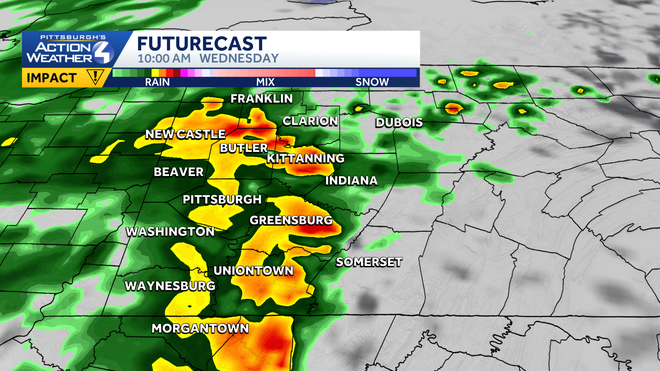
Heavy rain, and some thunder, will greet us Wednesday morning. Rain will last into the middle of the afternoon, making Wednesday an Impact Day.
Wednesday continues to trend wetter. Rain will quickly take over the rest of the day. A half inch to one inch of rain is expected. The wind will pick up along with the rain.
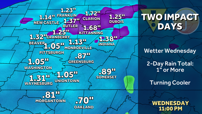
We can’t rule out an isolated thunderstorm either day. The best chances will be south of Pittsburgh. Any storms would likely be “garden variety” or non-severe Tuesday morning; activity on Wednesday could have a slight edge. Small hail and gusty winds are the storm threats. Rainfall totals from both days could top one inch across the region.
Hearst Owned
Most of the rain will fall on Wednesday in the form of heavy downpours and isolated thunderstorms.
Cooling down for marathon weekend
Temperatures will be cooler by the end of the week. Mornings will be in the 30’s with the potential for frost north and east of Pittsburgh. Daytime readings in the 50s for Pittsburgh Marathon weekend. Conditions should be dry for runners and spectators.
Hearst Owned
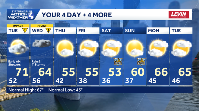
Drying out after back-to-back Impact Days. Temperatures also trend cooler for Western PA through the first weekend of May.
OVERNIGHT: Cloudy with early AM showers. Low: 52°.
TUESDAY – Impact Day: Early morning showers, mostly cloudy afternoon. High: 71°, low: 56°.
WEDNESDAY – Impact Day: Widespread rain and isolated thunderstorms. Breezy. High: 64°, low: 42°.
THURSDAY: Cooler with partly cloudy skies. High: 56°, low: 38°.