
Sct’d evening showers, then a cool first weekend of May in south-central Pennsylvania
Highs will stay near 60 degrees through Sunday, then more seasonable temperatures return early next week. Upper 70s are expected for early next week!
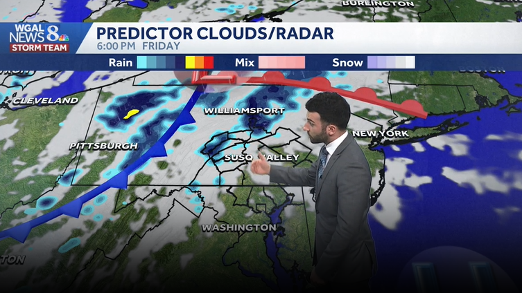
TOUGH SITUATION. NOW, THE WGAL NEWS EIGHT STORM TEAM FORECAST WITH METEOROLOGIST BRIAN ARGENTE. LOOKING AT SOME BLUE SKIES RIGHT NOW ACROSS THE AREA, YOU CAN SEE YORK SKY CAM AT THIS TIME SEEING REALLY JUST SOME HIGH LEVEL CLOUDS. HAD A LITTLE BIT OF A LIGHT AND VARIABLE BREEZE EARLIER. SAW THE AMERICAN FLAG WAVING IN THE BACKGROUND, BUT LIKE I MENTIONED, LIGHT AND VARIABLE WIND WILL HAVE. WE HAVE TEMPERATURES RIGHT NOW INTO THE MID 50S WITH WITH BRIGHT SUNSHINE ACROSS THE AREA. BUT THAT DOESN’T THAT DOESN’T LAST VERY MUCH LONGER. WILL STILL BE COOL FOR OUR FRIDAY, BUT WE ARE GOING TO BE SEEING SOME SCATTERED SHOWERS LATER ON LATE THIS AFTERNOON GETTING INTO THE EARLY EVENING HOURS. SO I DO EXPECT THE COVERAGE OF THOSE SHOWERS TO BE SCATTERED IN NATURE, MAINLY DRY FOR THE WEEKEND. HIGHS ARE ABOUT TEN DEGREES BELOW AVERAGE FOR THIS TIME OF YEAR, BUT WE DO HEAD BACK TO SEASONABLE LEVELS. I WOULD ACTUALLY SAY SOME SLIGHTLY UNSEASONABLY WARM CONDITIONS ONCE WE HEAD INTO NEXT WEEK. WE COULD BE SEEING HIGHS GETTING INTO THE UPPER 70S. WE MAY EVEN MAKE A RUN FOR THE LOW 80S. AS WE HEAD INTO NEXT WEEK. YOU’LL SEE THAT IN THE TEN DAY FORECAST IN JUST A FEW MINUTES, SO WE’LL EXPECT THOSE SCATTERED EVENING SHOWERS FOR TODAY, BUT WE’LL ENJOY SOME OF THAT SUNSHINE FOR THE NEXT SEVERAL HOURS HERE BEFORE GETTING INTO THE EVENING. TEMPERATURES TOPPING OUT IN THE LOWER 60S, BUT THEN 42 TO 46 FOR TONIGHT, SHOWERS WILL BEGIN TO END. WE’LL SEE SOME GRADUAL CLEARING FOR THE OVERNIGHT PERIOD. THEN WE’LL SEE SOME MORNING SUNSHINE AND MOSTLY CLOUDY CONDITIONS FOR TOMORROW AND A VERY SPOTTY SHOWER CHANCE FOR THE AFTERNOON. NOW KENTUCKY DERBY, THAT’S GOING TO BE TURNING ON TODAY, 230 IN THE AFTERNOON. THAT’S WHEN COVERAGE STARTS ON WGAL. WE’LL HAVE INCREASING CLOUDS FOR OUR SATURDAY, BUT IT’LL BE MOSTLY CLOUDY FOR ONCE THE RACE BEGINS, 58 DEGREES WILL BE RIGHT AROUND WHEN. THAT’S THE TEMPERATURES RIGHT AROUND THE. THE START TIME OF THE RACE. NOW POLLEN LEVELS FOR TODAY STILL REMAINING HIGH. LOW MOLD LEVELS, GOOD AIR QUALITY, AND A MODERATE UV INDEX. GOT ABOUT A 35 MINUTE BURN TIME FOR THE AFTERNOON, BUT TEMPERATURES ARE INTO THE MID 50S. RIGHT NOW. WE’RE 61 IN LEBANON. WE’RE 57 IN GETTYSBURG AT THIS HOUR. SO STILL EXPERIENCING SOME SUNSHINE WITH SOME HIGH LEVEL CLOUDS PUSHING THROUGH. BUT THEN HERE COMES SOME OF THESE SCATTERED SHOWERS BEGINNING TO MOVE IN FROM WEST TO EAST FROM THE OHIO RIVER VALLEY THAT’S ASSOCIATED WITH A COLD FRONT. AND THAT’S WHEN WE’LL START TO SEE ONCE THAT COLD FRONT APPROACHES, THAT’S WHEN WE’LL START TO SEE THAT SCATTERED SHOWER CHANCE COME THROUGH LATE THIS EVENING INTO EARLY TONIGHT IN THE WAKE OF THE COLD FRONT, WE’LL SEE SOME CLEARING. AND THAT’S A VERY SPOTTY SHOWER CHANCE. YOU CAN SEE SOME OF THE LIGHTER BLUES KIND OF POPPING UP HERE FOR SATURDAY, BUT MOST OF THE DRY, MOST OF THE DAY LOOKS DRY. AND REALLY, LIKE I MENTIONED, SPOTTY SHOWER CHANCES. THEN WE START TO CLEAR ONCE AGAIN FOR OUR SUNDAY. LOOKS LIKE WE’LL HAVE SOME HIGH PRESSURE BUILD IN THAT WILL HELP TO CLEAR OUR SKIES FOR THE SECOND HALF OF THE WEEKEND. NOW SHOWERS. IN TERMS OF HOW MUCH RAIN WE GET, IT’S NOT LOOKING LIKE A WHOLE LOT, BUT I WOULD SAY A COUPLE OF A FEW HUNDREDTHS OF AN INCH, MAYBE A 10TH OF AN INCH, WOULD BE ABOUT THE MAX THAT I WOULD SET THAT FOR SUNDAY OR EXCUSE ME, BY THE TIME WE GET THROUGH THE DAY, FRIDAY, I SHOULD SAY. NOW HEADING INTO NEXT WEEK, YOU CAN SEE MILDER CONDITIONS INTO THE 70S. UPPER 70S FOR OUR TUESDAY. A CHANCE O
Sct’d evening showers, then a cool first weekend of May in south-central Pennsylvania
Highs will stay near 60 degrees through Sunday, then more seasonable temperatures return early next week. Upper 70s are expected for early next week!

Updated: 12:26 PM EDT May 1, 2026
Abundant sunshine has been around for the day so far, although we’ll see increasing clouds later this afternoon and scattered showers will develop west to east between 5 p.m. and midnight, as a disturbance crosses Pennsylvania. Highs will reach 62 degrees, and rain totals will be light, up to 0.10″.Tonight, look for gradual clearing and be sure to check out the full Flower Moon! Lows will fall to the low 40s.Saturday will feature morning sun, then increasing clouds. Aside from a stray shower, it will be dry and cool, with highs in the upper 50s.Sunday looks breezy and cool, with highs near 60 and more sunshine.Next week, temperatures bounce back to seasonable averages. Expect highs near 70 degrees Monday, then mid-70s Tuesday. A chance of showers is in the forecast Tuesday into Wednesday, and again on Thursday. Temperatures at the end of the week will fall to the low 60s.Have a great Wednesday!~ Ryan
Abundant sunshine has been around for the day so far, although we’ll see increasing clouds later this afternoon and scattered showers will develop west to east between 5 p.m. and midnight, as a disturbance crosses Pennsylvania. Highs will reach 62 degrees, and rain totals will be light, up to 0.10″.
Tonight, look for gradual clearing and be sure to check out the full Flower Moon! Lows will fall to the low 40s.
Saturday will feature morning sun, then increasing clouds. Aside from a stray shower, it will be dry and cool, with highs in the upper 50s.
Sunday looks breezy and cool, with highs near 60 and more sunshine.
Next week, temperatures bounce back to seasonable averages. Expect highs near 70 degrees Monday, then mid-70s Tuesday. A chance of showers is in the forecast Tuesday into Wednesday, and again on Thursday. Temperatures at the end of the week will fall to the low 60s.
Have a great Wednesday!
~ Ryan