
Impact Day: Morning rain, late-day storm chance for western PA
It won’t rain all day long. The best storm chance is for areas northwest of Pittsburgh.
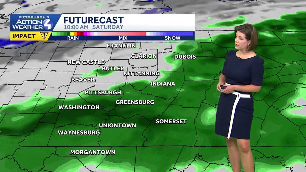
PITTSBURGH’S ACTION SPORTS. SWITCHING OVER TO PITTSBURGH’S ACTION WEATHER NOW METEOROLOGIST JILL SZWED WEATHER CERTIFIED MOST ACCURATE FORECAST. MOTHER’S DAY WEEKEND. BUT WE’RE ALSO EYEING AN IMPACT DAY, RIGHT? DAY TO START THIS MORNING WITH THAT LIGHT RAIN. BUT A GIFT TO ALL THE MOMS OUT THERE, WHETHER IT’S GOING TO BE A LITTLE BIT QUIETER FOR A GOOD PORTION OF THE WEEKEND. NOW, AS LOOK TOWARDS THIS EVENING, WE WILL LAUNCH A LINE OF THUNDERSTORMS THAT COULD ARISE, ESPECIALLY NORTH AND WEST OF THE CITY. AS WE GET CLOSER TO SUNSET. MEANWHILE, IN BETWEEN THOSE BATCHES OF UNSETTLED WEATHER, BREEZY, MILD TODAY WITH A HIGH CLOSE TO 70. LET’S GET YOU A LITTLE TOUR OF THE RADAR HERE. AS WE’RE WAKING UP ON A SATURDAY MORNING. MORE LIGHT RAIN STARTING TO PUSH IN CLOSER TO THE AIRPORT THAT WILL BE FILTERING IN ACROSS THE REST OF ALLEGHENY COUNTY HERE. AS WE GET CLOSER TO THE TOP OF THE 7:00 HOUR, AND CERTAINLY FOR THE NEXT SEVERAL HOURS TO COME. WE DO HAVE A POCKET OF SOME MODERATE RAIN WORKING AROUND BULLSKIN TOWNSHIP, ALSO DONEGAL RIGHT NOW. ANOTHER WAVE TRYING TO PUSH IN ACROSS FAR SOUTHWESTERN GREENE COUNTY FOR THE MOST PART, UP ALONG 422 AND I-80. YOUR RAIN IS LIGHT BUT STILL FAIRLY STEADY HERE AS WE’RE GETTING YOUR SATURDAY UNDERWAY. AGAIN, AN IMPACT DAY FOR A REASON. BIT OF A SOGGY START TO THE MORNING. IF YOU’RE OFF TO LITTLE LEAGUE GAMES OR PRACTICES. CERTAINLY WANT TO CHECK THE FIELD CONDITIONS AND ALSO THEN PLAN AHEAD FOR SOME RAIN GEAR AS WE GO THROUGH THIS MORNING INTO THE AFTERNOON, WE WILL BE DRIER WITH A HIGH CLOSER TO 70. STAYING MILD INTO YOUR MOTHER’S DAY. JUST A LIMITED SHOWER CHANCE THAT LOOKS TO HIT AROUND MIDDAY TOMORROW. AND NICE TO SEE MORE SUNSHINE. YOUR FOUR DAY FORECAST. ALTHOUGH TEMPERATURES WILL STAY COOL AS WE KICK OFF NEXT WEEK. LET’S GO HOUR BY HOUR ON THIS IMPACT DAY THROUGH ABOUT NINE 10:00. MOST OF WESTERN PENNSYLVANIA DEALING WITH THAT LIGHT RAIN AS WE ROLL THROUGH THE SECOND HALF OF THE MORNING. THAT’S WHEN A LOT OF THIS RAIN WILL BE SHUTTING OFF, WORKING FROM WEST TO EAST EVEN AS EARLY AS 1:00 O’CLOCK. SOME RAYS OF SUNSHINE POKING THROUGH A CLOSER TO NEW CASTLE AND BEAVER. WE ALL GET IN ON SOME OF THAT SUNSHINE AS WE GO THROUGH THE SECOND PART OF THE DAY. KEEP AN EYE ON WHAT’S COMING IN ON THE NORTH AND WEST. THIS IS A COLD FRONT SWINGING AND TIMING NOT EXACTLY ON THE SIDE OF THE STORMS. AS WE WILL SEE THIS LINE STARTING TO BREAK APART AND WEAKEN AS WE GO THROUGH THE HOURS SHORTLY AFTER SUNSET, BUT STILL NORTH AND WEST OF THE CITY, YOU MAY FIND SOME RUMBLES OF THUNDER COULD PACK A PUNCH WITH SOME GUSTY WINDS AND EVEN SOME HAIL. YOU CAN SEE THAT DARKER SHADE OF GREEN. NORTHERN BEAVER COUNTY, ALL OF LAWRENCE, PARTS OF BUTLER CLARION ALL VENANGO COUNTIES INCLUDED IN THAT. AND THE TIMING REALLY TO SEE SOME OF THOSE ISOLATED STORMS WILL BE BETWEEN ABOUT 7:00 AND MIDNIGHT. I DON’T KNOW HOW MUCH IS GOING TO MAKE IT INTO THE CITY OF PITTSBURGH, JUST GIVEN THE TIMING. BUT STILL, WE’LL BE TRACKING THAT AS WE GO THROUGH THE SECOND HALF OF THE DAY AND CERTAINLY INTO THE FIRST PART OF TONIGHT. I WAKE UP TOMORROW TO SOME AREAS OF PATCHY FOG. OTHERWISE A MIX OF SUNSHINE AND CLOUDS. YOU MAY HAVE SEEN JUST A BRIEF LITTLE BLIP OF GREEN THERE ON FUTURECAST. JUST A STRAY SHOWER CHANCE ON MOTHER’S DAY, BUT OVERALL, NOT A BAD DAY TO CELEBRATE. MOM, TOMORROW, 67 IS THE WEEKEND COOLER STILL MONDAY AND TUESDAY WITH HIGHS CLOSE TO 60. WE WILL SEE SOME AREAS OF PATCHY FROST, ESPECIALLY NORTH AND EAST OF THE CITY ON TUESDAY, BUT AFTER THAT WE WILL START TO SEE TEMPERATURES STARTING TO WARM UP. SO GOING TO GET THROUGH A RAINY DAY THOUGH ON WEDNESDAY THAT HAS THE POTENTIAL TO BE AN IMPACT DAY, NOT JUST FOR THE RAIN, BUT ALSO THUNDERSTORM THREAT. AND AS WE FAST FORWARD INTO NEXT WEEKEND, TEMPERATURES ARE STARTING TO WARM BACK UP INTO THE MID 70S AND HOPEFULLY THEN FINALLY STAY THERE. AS WE WERE TALKING ABOUT EARLIER THIS WEEK, FIRST PART OF MAY LOOKS TO BE COOL. SECOND HALF MAY BE GETTING A LITTLE BIT WARMER. SO IT LOOKS LIKE THAT TIDE IS ABOUT TO TURN ABOUT A WEEK FROM TODAY. YOU LOVE TO HEAR THAT, BUT OF COURSE, IT’S ALSO A GREAT REMINDER FOR FOLKS BECAUSE ALL OF THIS CHANGING WEATHER HAVE THAT WTAE UP TO DATE, ESPECIALLY IF YOU’RE OUT AND ABO
Impact Day: Morning rain, late-day storm chance for western PA
It won’t rain all day long. The best storm chance is for areas northwest of Pittsburgh.

Updated: 6:58 AM EDT May 9, 2026
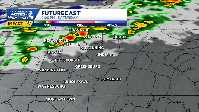
Many are waking up to light rain, but it won’t last all day long. This Impact Day also features an evening storm chance. Areas northwest of Pittsburgh have a better chance of catching a stronger storm. We can’t rule out a stray shower for Mother’s Day.Impact Day: Morning rain, evening storm chanceToday is an Impact Day for widespread morning rain. It won’t be an all-day soaker. Rain looks to push out by noon. Western Pennsylvania will remain dry until a cold front approaches late tonight and into Sunday morning. There is an isolated storm risk, especially northwest of Pittsburgh, between 7 p.m. and 10 p.m. Gusty winds and hail are the primary storm threats. Given the timing, any storms that develop won’t last long. Thunder and rain will fade by midnight.Mother’s Day forecastMother’s Day will feature comfortable temperatures around western PA. After staring in the low 50s, temperatures will reach the mid to upper 60s. We can’t rule out stray afternoon showers. But it won’t be a bad day weather-wise to celebrate mom. Between half an inch and three-quarters of an inch of rain are expected by the end of the weekend.A warm up in sightTemperatures will lend cooler again Monday and Tuesday with highs around 60 degrees. Another bout of frost is possible Tuesday morning. Showers return on Wednesday with a chance for storms as a system swings through the Pittsburgh area. We finally start to warm up next weekend with high temperatures returning to the 70s, which is where we are supposed to be for the middle of May.TODAY – Impact Day: Morning rain, some afternoon sunshine. Breezy and mild, high: 70°.TONIGHT: Evening storms, especially northwest of Pittsburgh. Patchy fog. Low: 52°.SUNDAY: Sunshine at times with isolated showers. High: 67°, low: 44°.MONDAY: Decreasing clouds but not as warm. High: 59°, low: 38°.TUESDAY: Areas of morning frost. Mostly sunny and still cool. High: 63°, low: 46°.
PITTSBURGH —
Many are waking up to light rain, but it won’t last all day long. This Impact Day also features an evening storm chance. Areas northwest of Pittsburgh have a better chance of catching a stronger storm. We can’t rule out a stray shower for Mother’s Day.
Impact Day: Morning rain, evening storm chance
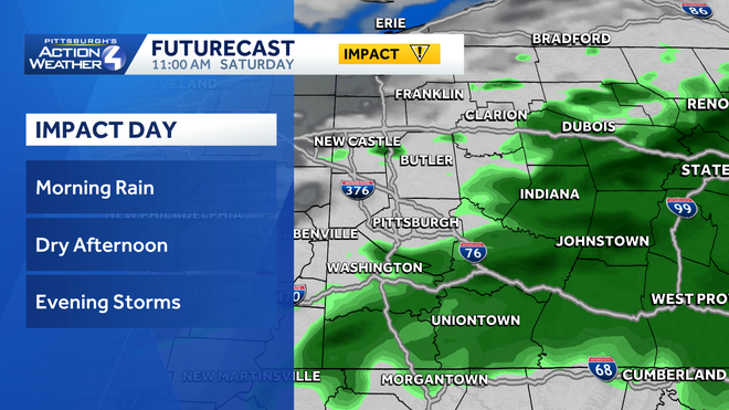
Today is an Impact Day for widespread morning rain. It won’t be an all-day soaker. Rain looks to push out by noon. Western Pennsylvania will remain dry until a cold front approaches late tonight and into Sunday morning.
Hearst OwnedHearst
This morning’s rain will exit to the east by 11 a.m.
Hearst OwnedHearst
A cold front could pop isolated storms, especially northwest of Pittsburgh, this evening.
Mother’s Day forecast
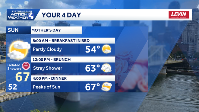
Mother’s Day will feature comfortable temperatures around western PA. After staring in the low 50s, temperatures will reach the mid to upper 60s. We can’t rule out stray afternoon showers. But it won’t be a bad day weather-wise to celebrate mom. Between half an inch and three-quarters of an inch of rain are expected by the end of the weekend.
A warm up in sight
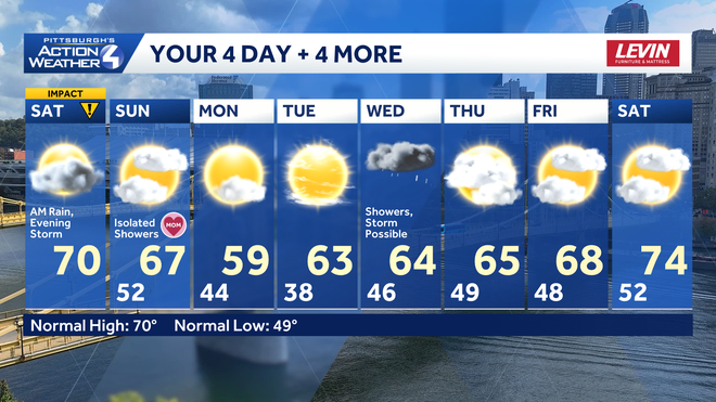
Temperatures will lend cooler again Monday and Tuesday with highs around 60 degrees. Another bout of frost is possible Tuesday morning. Showers return on Wednesday with a chance for storms as a system swings through the Pittsburgh area. We finally start to warm up next weekend with high temperatures returning to the 70s, which is where we are supposed to be for the middle of May.
Hearst OwnedHearst
More rain with the potential for storms on Wednesday. Temperatures will start warming up next weekend.
TODAY – Impact Day: Morning rain, some afternoon sunshine. Breezy and mild, high: 70°.
TONIGHT: Evening storms, especially northwest of Pittsburgh. Patchy fog. Low: 52°.
SUNDAY: Sunshine at times with isolated showers. High: 67°, low: 44°.
MONDAY: Decreasing clouds but not as warm. High: 59°, low: 38°.
TUESDAY: Areas of morning frost. Mostly sunny and still cool. High: 63°, low: 46°.