
Pittsburgh: Pleasant temperatures, stray shower for Mother’s Day
Most of the western Pennsylvania remains dry today through Tuesday.
THE SERIES. THE FIRST IS IN THE SOUTH SIDE. ALL RIGHT, AS PROMISED. TURNING BACK NOW TO METEOROLOGIST JILL SZWED HERE ON THIS MOTHER’S DAY WITH THE CERTIFIED MOST ACCURATE FORECAST, WHAT DO WE HAVE TO LOOK FORWARD TO? A PRETTY NICE DAY. ALL IN ALL, MAYBE A LITTLE BIT OF A SLOW MORNING FOR ALL THE MOMS, BUT THAT’S MAYBE JUST WHAT SOME MOMS WANT HERE. AS WE GET STARTED, WE DO HAVE SOME CLOUDS. ALSO SOME AREAS OF FOG HERE AS WE GET THE DAY STARTED. CAN’T RULE OUT SOME STRAY SHOWERS THAT WILL CROSS BETWEEN ABOUT EIGHT 9:00 THROUGH THE NOON HOUR. OTHERWISE, WE’LL CHIP AWAY AT THAT CLOUD DECK, BRINGING MORE SUNSHINE AND VERY PLEASANT TEMPERATURES AS WE WORK THROUGH THE AFTERNOON. BUT OVERALL, STILL THIS COOL TREND THROUGH THE MONTH OF MAY DOES CONTINUE FOR THE BETTER PART OF THIS UPCOMING WEEK, WE ARE EYEING MORE RAIN ON WEDNESDAY. ACTUALLY HAS THE POTENTIAL TO BE AN IMPACT DAY AS WE COULD ONLY SEE RAIN, BUT EVEN THE POSSIBILITY OF A FEW THUNDERSTORMS THROUGH THE AFTERNOON. THINGS ARE STARTING TO CLEAR OUT OVER DOWNTOWN PITTSBURGH. THE RAIN IS GONE. YOU CAN SEE SOME SHADES OF PINK HERE ON THIS MOTHER’S DAY MORNING. AS WE LOOK INTO THE EASTERN SKY, AS WE GO THROUGH THE MORNING, MORE CLOUDS WILL BE BUILDING IN. ALSO MONITORING SOME AREAS OF PATCHY FOG, ESPECIALLY UP ALONG 422. AND ALSO THE I-80 CORRIDOR. SO STRAY SHOWERS HERE THIS MORNING, OTHERWISE CLEARING INTO THE AFTERNOON 66 FOR A HIGH. NOTICE THOSE TEMPERATURES STILL HOLDING STEADY LOW TO MID 60S FOR THE BETTER PART OF THE WEEK. LITTLE HICCUP MIDWEEK WITH THAT RAIN CHANCE ON WEDNESDAY, BUT THEN BY THIS TIME NEXT WEEKEND WE’RE GOING TO BE WARMING UP AND RIGHT ON CUE WITH TEMPERATURES WELL INTO THE 70S FOR THE TIME BEING, EXPECTING THOSE CLOUDS TO CONTINUE TO ROLL IN HERE THIS MORNING. WE’LL PAUSE AT 9:00 ON FUTURECAST. YOU CAN SEE SOME VERY HIT OR MISS SHOWERS. ANY RAIN ACTIVITY THAT DOES POP UP IS GOING TO BE LIGHT AND BRIEF IN NATURE, AND SHOULD BE MOVING ALONG PRETTY QUICKLY. BUT JUST SOMETHING TO BE MINDFUL OF IF YOU’RE OFF TO CHURCH, OR MAYBE SOME EARLY BREAKFAST PLANS WITH MOM. A LOT OF THOSE SHOWERS MOVING OFF TOWARDS THE EAST AS WE GET CLOSER TO NOON AT 1:00. ALREADY STARTING TO SEE SOME CLEARING COMING IN FROM THE NORTHWEST WILL BE THE THEME AS WE GO THROUGH THE SECOND HALF OF THE DAY. FEW CLOUDS TRYING TO STREAM BACK IN LATE TONIGHT, BUT THEN AS WE WAKE UP, TOMORROW SHOULD BE A BEAUTIFUL SUNRISE TO KICK OFF YOUR MONDAY. FEW CLOUDS DRIFTING IN THROUGH THE AFTERNOON, YOU MAY HAVE NOTICED A LITTLE SPLASH OF GREEN, MORE THAN LIKELY FUTURECAST. PICKING UP ON SOME OF THOSE TALLER CLOUD TOPS WILL BE DEVELOPING INTO THE AFTERNOON, BUT OTHERWISE HIGH PRESSURE IS ROLLING IN FOR THE START OF THE WEEK. THAT WILL CLEAR US OUT PRETTY QUICKLY BY DAYBREAK ON TUESDAY, A CONCERN FOR SOME AREAS OF FROST AND EVEN A FREEZE AS WE GET YOU SET FOR YOUR TUESDAY. SO 66 TODAY, INTRODUCING MORE SUNSHINE AS WE GO THROUGH THE UPCOMING WEEK. CHECK OUT THESE LOW TEMPERATURES TUESDAY MORNING. MOST OF US DEALING WITH A FROST BUT STILL A FREEZE IS POSSIBLE UP ALONG 422 AND I-80, SO DO EXPECT SOME FROST AND FREEZE ALERTS TO COME OUR WAY. MAY HAVE HAD AN IMPACT DAY TO WEDNESDAY AS WE ARE EXPECTING SHOWERS THROUGHOUT THE DAY. POSSIBILITY OF AN AFTERNOON STORM WILL START TO DRY THINGS OUT. SECOND HALF OF THE WEEK. WARM IT UP TO IN YOUR 4-DAY PLUS 4 MORE FORECAST SKIPPING RIGHT AHEAD INTO THE MID 70S. NEXT WEEKEND. WE MONITOR YOUR SHOWER CHANCE AND WAFFLING BACK AND FORTH BETWEEN FRIDAY, SATURDAY AND EVEN SUNDAY. BUT HOPEFULLY WE CAN KEEP THINGS DRY FOR THE KOMEN MORE THAN PINK WALK. OF COURSE, EVERYBODY FROM WTAE CHANNEL 4 WILL BE OUT NEXT SUNDAY MORNING. YEAH, ONE WEEK FROM TODAY. WE ALL LOOK FORWARD TO THAT EVERY YEAR. AND IT’S GOING TO BE HALFWAY THROUGH MAY, BEFORE MAY FINALLY ARRIVE. MAY FINALLY SHOWS UP. I KNOW IT’S SPRING HAS BEEN WORKING IN REVERSE AT LEAS
Pittsburgh: Pleasant temperatures, stray shower for Mother’s Day
Most of the western Pennsylvania remains dry today through Tuesday.

Updated: 5:32 AM EDT May 10, 2026
Happy Mother’s Day! Most of the Pittsburgh area remains dry today through Tuesday. The cool trend also continues. The next rain chance is Wednesday. A warm trend begins next weekend.Mother’s Day forecastClouds with patchy fog and drizzle linger this morning. Very isolated, light showers will cross the area before noon. The coverage will be very limited and most of the area remains dry. Skies will brighten through the afternoon with pleasant temperatures in the mid 60s.Cool trend continuesThe cooler than normal start of May extends into Thursday. High temperatures will only manage to low and mid 60s. Nights will be chilly, especially Monday night. Clear, calm and quiet conditions will make frost likely and a freeze possible for western Pennsylvania. Expect frost and freeze alerts to be issued.Next rain chance Wednesday, warm up on the wayWe are watching a system for Wednesday. Rain will arrive through the night and likely be widespread for the Wednesday morning commute. Depending on the timing in a lull in the activity, a few thunderstorms are possible during the second half of the day. An Impact Day is possible.Warmer days are in our future. Highs skip ahead into the mid 70s for next weekend.TODAY: Stray shower before noon. Pleasant with afternoon clearing. High: 66°.TONIGHT: Clouds early, some clearing by daybreak. Low: 45°.MONDAY: Cool with sun and clouds. High: 60°, low: 37°.TUESDAY: Frosty start, still cool despite sunshine. High: 64°, low: 48°.WEDNESDAY: Showers likely, afternoon storm possible. High: 64°, low: 48°.
PITTSBURGH —
Happy Mother’s Day! Most of the Pittsburgh area remains dry today through Tuesday. The cool trend also continues. The next rain chance is Wednesday. A warm trend begins next weekend.
Mother’s Day forecast
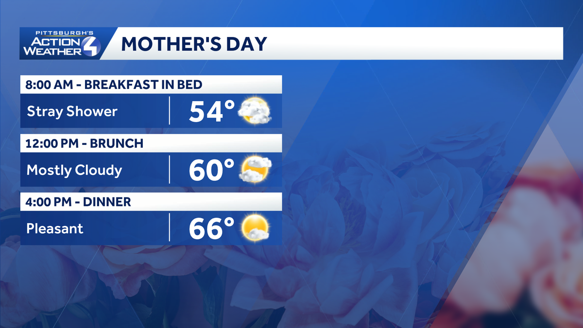
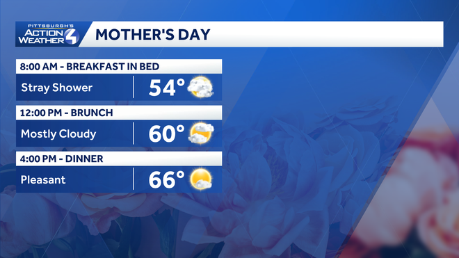
Clouds with patchy fog and drizzle linger this morning. Very isolated, light showers will cross the area before noon. The coverage will be very limited and most of the area remains dry. Skies will brighten through the afternoon with pleasant temperatures in the mid 60s.
Hearst OwnedHearst
A stray shower is possible before noon. Sunshine returns with pleasant temperatures this afternoon.
Cool trend continues
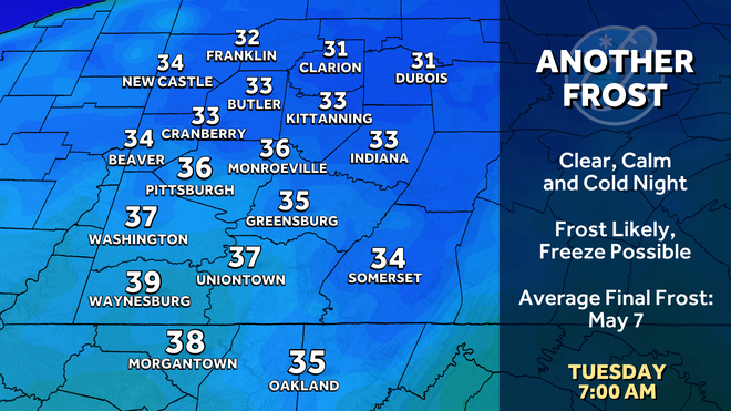
The cooler than normal start of May extends into Thursday. High temperatures will only manage to low and mid 60s. Nights will be chilly, especially Monday night. Clear, calm and quiet conditions will make frost likely and a freeze possible for western Pennsylvania. Expect frost and freeze alerts to be issued.
Hearst OwnedHearst
Protect your plants Monday night. Frosty is likely, a freeze possible north by Tuesday morning.
Next rain chance Wednesday, warm up on the way
We are watching a system for Wednesday. Rain will arrive through the night and likely be widespread for the Wednesday morning commute. Depending on the timing in a lull in the activity, a few thunderstorms are possible during the second half of the day. An Impact Day is possible.
Warmer days are in our future. Highs skip ahead into the mid 70s for next weekend.
Hearst OwnedHearst
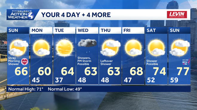
Another wet Wednesday for Pittsburgh. Conditions dry out and temperatures start to warm by next weekend.
TODAY: Stray shower before noon. Pleasant with afternoon clearing. High: 66°.
TONIGHT: Clouds early, some clearing by daybreak. Low: 45°.
MONDAY: Cool with sun and clouds. High: 60°, low: 37°.
TUESDAY: Frosty start, still cool despite sunshine. High: 64°, low: 48°.
WEDNESDAY: Showers likely, afternoon storm possible. High: 64°, low: 48°.