
SHORT TERM FORECAST
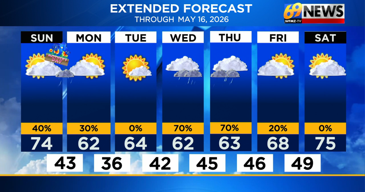
MOTHER’S DAY: AM patchy fog; partly sunny with a stray PM shower. High: 74
TONIGHT: Mostly cloudy with a stray shower. Low: 43
MONDAY: Partly sunny and cooler. High: 62 Low: 36
FORECAST SUMMARY
After a cool and wet start to the weekend Saturday, moms will get a warmer and (mostly) drier day of the weekend for Mother’s Day on Sunday. Highs will climb past the 70° mark for the first time since the early week, and we likely won’t hit 70° again until the upcoming weekend. But moms should enjoy a noticeably milder day with morning low clouds and fog giving way to partly sunny skies, which will in turn give way to a few extra clouds and a couple of passing showers in the afternoon. Any showers should be light and scattered, so the day is more dry than wet overall. A couple of showers are possible tonight into early Monday morning, before we get a brief break from the rain chances later Monday through all of Tuesday. While cool with highs in the low to mid 60s, it looks mostly dry from midday Monday through Tuesday night. Wednesday and Thursday will offer up the cloudiest and wettest weather of the forecast, with occasional rain or rain showers expected both days, and highs again mired in the low 60s. By the end of next week and especially next weekend, we may start to transition from the cooler and unsettled pattern we’ve been stuck in to something warmer and drier for the second half of May.
DETAILED FORECAST
MOTHER’S DAY
Moms get the warmer and drier (but not entirely dry) weekend day, with some patchy morning fog giving way to partly sunny skies for most of the day. Highs will reach the low to mid 70s, the warmest day we’ve seen since early last week, and the warmest day we will see until next weekend. A cold front will approach from the west and deliver the chance for at least some passing light rain showers this afternoon, but rainfall amounts will be light (a few hundredths of an inch) and rain will be spotty, so not everyone gets wet. Mostly cloudy skies and a few showers will be the rule Sunday night, with the best chance of showers the farther south from the Lehigh Valley you travel.
EARLY NEXT WEEK
We’ll begin the new work and school week with some clouds and lingering scattered showers Monday morning, but again, mainly south of I-78. Things should then dry up and clear out later Monday into Tuesday, but it will remain cool. The average high for mid-May is in the low to mid 70s, and we’ll be in the low to mid 60s Monday and Tuesday. Tuesday is our best chance for a mostly sunny and entirely dry day for the upcoming week. Also, we may have to watch out for some patchy frost Tuesday night as lows should dip into the mid to upper 30s presuming skies are clearer by then.
WEDNESDAY AND THURSDAY
Here’s our best shot for cloudier and wetter weather for the coming week, as a pair of cloudy, cool, and occasionally wet days are expected with occasional rain and rain showers for the better part of Wednesday through at least some or most of Thursday, before things dry out Friday. Temperatures, much like they have been often, will be stuck in the low 60s, with rainfall amounts, at least for now, looking to be around a half-inch for both days combined. While not a soaking rain, it does look damp and cool mid-week.
LATER NEXT WEEK
We may finally turn the corner and flip the page to some warmer and drier weather, with Friday the possible transition day to some widespread warmth by next weekend. Highs may approach 70-degrees on Friday, before surging well into the 70s both weekend days next weekend. It also looks mostly dry with only small rain chances next Friday through Sunday.
TRACK THE WEATHER:
LINKS: HOUR BY HOUR | RADAR | TRAFFIC