
Dry and Sunny Start to Week, Showers Return Wednesday
Continued cooler than average to start the week
TO PREVENT OVERHEATING. AND I’M SITTING HERE WITH SOMEONE WHO KNOWS A LITTLE BIT ABOUT THE WEATHER THAT COULD GIVE SOME ADVICE, RIGHT? YEAH, WE MAY SEE SOME FROST IN THE AREA LOCALLY TOMORROW NIGHT, MONDAY INTO TUESDAY, BUT NOT SO MUCH TONIGHT UNLESS YOU’RE GOING TO BE NORTH OF I-80 OR RESIDING THERE WHERE THERE COULD BE SOME PATCHY FROST. THIS MORNING WE STARTED AT 50, ENDED AT 64 THIS AFTERNOON. ONCE THE CLOUDS BROKE, WE DID A LATE DAY RALLY WITH THOSE TEMPERATURES, AND THE NEXT COUPLE OF DAYS SHOULD BE IN THAT LOW TO MID 60 DEGREE RANGE. PLENTY OF SUNSHINE MONDAY AND TUESDAY. NOTICE THAT TUESDAY MORNING. LOW DOWN AROUND 37 DEGREES. SO THAT WILL BE THE PERIOD AT WHICH YOU’VE DONE ANY EARLY SEASON PLANTING THAT YOU WANT TO PROTECT THAT TENDER VEGETATION. SCATTERED SHOWERS RETURN MIDWEEK AND TEMPERATURES WILL STAY IN THAT LOW 60 DEGREE RANGE RIGHT THROUGH THURSDAY. RIGHT NOW WE’RE SITTING IN THE LOW TO MID 60S IN PARTS OF THE AREA. AS OF LATE SUNDAY AFTERNOON. 63 GREENSBURG PITTSBURGH 62. UNIONTOWN WAYNESBURG AT 60 DEGREES. JUST PATCHY CLOUDS ACROSS THE AREA SHOULD BE CLEAR TO. PARTLY CLOUDY FOR US OVERNIGHT TONIGHT AND AGAIN. AREAS NORTH OF I-80. NORTHERN PARTS OF JEFFERSON, CLARION AND VENANGO COUNTY MAY SEE SOME PATCHY FROST TOMORROW MORNING. LOCALLY, TEMPERATURES ONLY DOWN TOWARD THE LOW 40S TO START THE DAY TOMORROW BY 6 A.M., 43 DEGREES, AND THEN THROUGH THE DAY TOMORROW. TEMPERATURES SHOULD RECOVER TO AROUND 61 FOR AFTERNOON. HIGH AT MIDDAY SHOULD BE AROUND 54 DEGREES. BUT A GREAT LOOKING DAY TOMORROW. HERE’S FUTURECAST TAKING YOU THROUGH THE NEXT COUPLE OF DAYS. 730 TOMORROW MORNING. MAYBE SOME HIGH CLOUDINESS FOR UNIONTOWN AND MORGANTOWN LOCALLY SHOULD BE MAINLY CLEAR IN POINTS NORTH THROUGH THE AFTERNOON. A MIXTURE OF CLOUDS AND SUNSHINE. WE’LL CLEAR OUT ALL TOGETHER MONDAY NIGHT INTO TUESDAY MORNING. THIS IS THE PERIOD AT WHICH WE COULD SEE SOME PATCHY FROST LOCALLY, AND THEN THROUGH THE DAY ON TUESDAY MAY SEE AN INCREASE IN CLOUDS. LATE DAY, BUT ANOTHER DRY DAY FROM START TO FINISH. WITH THAT NEXT PUSH OF RAIN SHOWERS NOT ARRIVING UNTIL YOU’LL SEE 11:00 ON TUESDAY NIGHT. SO IT’S GOING TO BE LATE NIGHT TUESDAY INTO WEDNESDAY THAT WE SEE THAT NEXT ROUND OF SCATTERED RAIN SHOWERS, 63 THE HIGH ON WEDNESDAY. THURSDAY DRY 62. AND THEN LOOKING AHEAD TOWARD NEXT WEEKEND, YOU’LL SEE TEMPERATURES FINALLY BEGIN TO RECOVER. I’VE BEEN GETTING A LOT OF QUESTIONS. WHEN ARE WE GETTIN
Dry and Sunny Start to Week, Showers Return Wednesday
Continued cooler than average to start the week

Updated: 6:54 PM EDT May 10, 2026
The cooler than average trend continue to start the week. The next rain chance is Wednesday. A warmer trend arrives next weekend. Cool trend continuesDry skies have returned to the area and will continue to start the week. High temperatures will only manage to low and mid 60s through mid week. Nights will be chilly, especially Monday night. Clear, calm and quiet conditions will make areas of frost possible for parts of the area Monday night. The good news is…both Monday and Tuesday will feature a nice mix of clouds and sunshine!Next rain chance Wednesday, warm up on the wayWe are watching our next system for Wednesday. Showers might arrive late Tuesday night and carry over into Wednesday morning commute. There likely will be lull in the activity for much of Wednesday afternoon, with just a few leftover showers possible.Warmer days are in our future. Highs will sfinally surge back into the 70s next weekend.TONIGHT: Partly cloudy. Low: 43°.MONDAY: Mix of sun and clouds. High: 61°TUESDAY: Areas of frost to start, Mostly sunny. High: 65°WEDNESDAY: Mostly cloudy. Sct’d Showers. High: 63°
PITTSBURGH —
The cooler than average trend continue to start the week. The next rain chance is Wednesday. A warmer trend arrives next weekend.
Cool trend continues
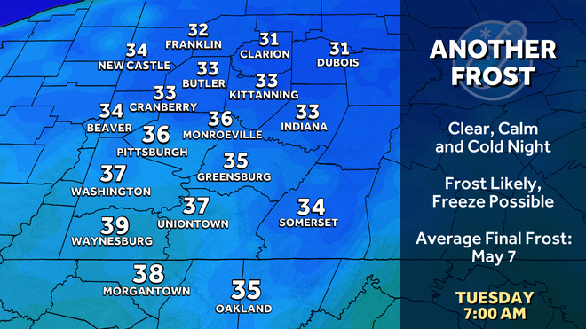
Dry skies have returned to the area and will continue to start the week. High temperatures will only manage to low and mid 60s through mid week. Nights will be chilly, especially Monday night. Clear, calm and quiet conditions will make areas of frost possible for parts of the area Monday night. The good news is…both Monday and Tuesday will feature a nice mix of clouds and sunshine!
Hearst OwnedHearst
Protect your plants Monday night. Frosty is likely, a freeze possible north by Tuesday morning.
Next rain chance Wednesday, warm up on the way
We are watching our next system for Wednesday. Showers might arrive late Tuesday night and carry over into Wednesday morning commute. There likely will be lull in the activity for much of Wednesday afternoon, with just a few leftover showers possible.
Warmer days are in our future. Highs will sfinally surge back into the 70s next weekend.
Hearst OwnedHearst
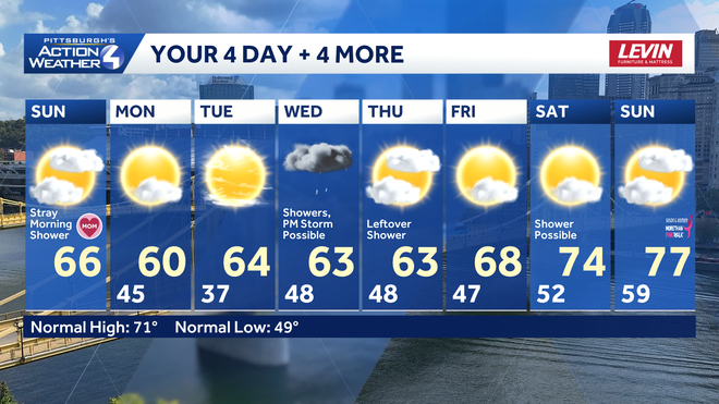
Another wet Wednesday for Pittsburgh. Conditions dry out and temperatures start to warm by next weekend.
TONIGHT: Partly cloudy. Low: 43°.
MONDAY: Mix of sun and clouds. High: 61°
TUESDAY: Areas of frost to start, Mostly sunny. High: 65°
WEDNESDAY: Mostly cloudy. Sct’d Showers. High: 63°